The Astley Green Colliery Museum is a museum run by the Red Rose Steam Society in Astley near Tyldesley in Greater Manchester, England. Before becoming a museum, the site was a working colliery that produced coal from 1912 to 1970; it is now protected as a Scheduled Monument. The museum occupies a 15-acre (6 ha) site by the Bridgewater Canal which has the only surviving pit headgear and engine house on the Lancashire Coalfield.

Smithills Hall is a Grade I listed manor house, and a scheduled monument in Smithills, Bolton, Greater Manchester, England. It stands on the slopes of the West Pennine Moors above Bolton at a height of 500 feet, three miles north west of the town centre. It occupies a defensive site near the Astley and Raveden Brooks. One of the oldest manor houses in the north west of England, its oldest parts, including the great hall, date from the 15th century and it has been since been altered and extended particularly the west part. Parts of it were moated. The property is owned by Bolton Metropolitan Borough Council and open to the public.

Weeting Castle is a ruined, medieval manor house near the village of Weeting in Norfolk, England. It was built around 1180 by Hugh de Plais, and comprised a three-storey tower, a substantial hall, and a service block, with a separate kitchen positioned near the house. A moat was later dug around the site in the 13th century. The house was not fortified, although it drew on architectural features typically found in castles of the period, and instead formed a very large, high-status domestic dwelling. It was probably intended to resemble the hall at Castle Acre Castle, owned by Hugh's feudal lord, Hamelin de Warenne.

Clayton Hall is a 15th-century manor house on Ashton New Road, in Clayton, Manchester, England. It is hidden behind trees in a small park. The hall is a Grade II* listed building, the mound on which it is built is a scheduled ancient monument, and a rare example of a medieval moated site. The hall is surrounded by a moat, making an island 66 m by 74 m. Alterations were made to the hall in the 16th and 17th centuries, and it was enlarged in the 18th century.
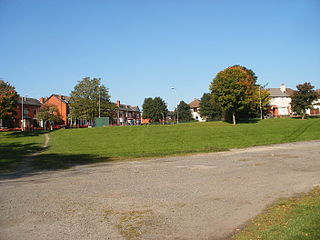
Shakerley is a suburb of Tyldesley in the Metropolitan Borough of Wigan, Greater Manchester, England. It was anciently a hamlet in the northwest of the township of Tyldesley cum Shakerley, in the ancient parish of Leigh. The boundary between Shakerley and Hindsford is the Hindsford Brook. It remains the boundary between Tyldesley and Atherton. Hyndforth Bridge across the brook, was rebuilt in stone in 1629.
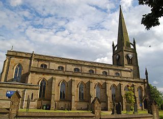
St George's Church is an Anglican parish church serving Tyldesley and Shakerley in Greater Manchester, England. It is part of Leigh deanery in the archdeaconry of Salford and the diocese of Manchester. The church, together with St Stephen's Church, Astley and St John's Church, Mosley Common is part of the united benefice of Astley, Tyldesley and Mosley Common.

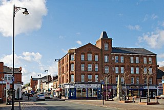
Tyldesley cum Shakerley Urban District and its successor Tyldesley Urban District was, from 1894 to 1974, a local government district in Lancashire, England.
The Astley and Tyldesley Collieries Company formed in 1900 owned coal mines on the Lancashire Coalfield south of the railway in Astley and Tyldesley, then in the historic county of Lancashire, England. The company became part of Manchester Collieries in 1929 and some of its collieries were nationalised in 1947.
Tyldesley Coal Company was a coal mining company formed in 1870 in Tyldesley, on the Manchester Coalfield in the historic county of Lancashire, England that had its origins in Yew Tree Colliery, the location for a mining disaster that killed 25 men and boys in 1858.
Ramsden's Shakerley Collieries was a coal mining company operating the Nelson and Wellington Pits from the mid 19th century in Shakerley, Tyldesley in the historic county of Lancashire, England.

Bedford, a suburb of Leigh, Greater Manchester is one of three ancient townships, Bedford, Pennington and Westleigh, that merged in 1875 to form the town of Leigh. Historically, Bedford was in Lancashire.
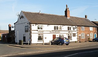
Great Boys Colliery was a coal mine operating on the Manchester Coalfield in the second half of the 19th century in Tyldesley, then in the historic county of Lancashire, England. It was sunk on Great Boys farm, which in 1778 was described as a "messuage with eight Cheshire acres of land" on the north side of Sale Lane west of the Colliers Arms public house. It was owned by William Atkin and sold in 1855 to mineowners, John Fletcher of Bolton and Samuel Scowcroft. By 1869 their partnership was dissolved and the company became John Fletcher and Sons in 1877. Shafts were sunk for a colliery on Pear Tree Farm on the corner of Mort Lane and Sale Lane which appear in the 1867 Mines Lists and became part of Great Boys Colliery. Fletcher and Schofield were granted permission to construct a mineral railway to join the London and North Western Railway's Tyldesley Loopline in 1868 but there is no evidence that it was built. The colliery closed before 1885. The colliery accessed the Brassey mine at about 170 yards and the Six Foot mine at 182 yards. The deeper coal seams were accessed by New Lester Colliery.

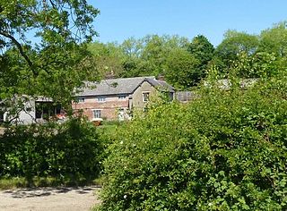
Morleys Hall, a moated hall converted to two houses, is situated at grid reference SJ 689 992 on Morleys Lane, on the edge of Astley Moss in Astley, Greater Manchester, England. It was largely rebuilt in the 19th century on the site of a medieval timber house. The hall is a Grade II* listed building and the moat a scheduled ancient monument. Morleys is a private residence.
Yew Tree Colliery was a coal mine operating on the Manchester Coalfield after 1845 in Tyldesley, Greater Manchester, then in the historic county of Lancashire, England.
Astley is a settlement in the Metropolitan Borough of Wigan in Greater Manchester, England. Originally a village, it now forms a continuous urban area with Tyldesley to the north. It lies on flat land north of Chat Moss and is crossed by the Bridgewater Canal and the A580 "East Lancashire Road". Astley contains several listed buildings designated by English Heritage and included in the National Heritage List for England. Most are listed at Grade II, the lowest of the three gradings given to listed buildings and is applied to "buildings of national importance and special interest".
Garrett Hall or The Garrett is a former manor house and now a grade II listed farmhouse in Tyldesley, Greater Manchester, England. The hall was designated a grade II listed building in 1987.
Chaddock Hall was an ancient hall on Chaddock Lane in Tyldesley, Greater Manchester, England. It was designated a Grade II listed building in 1966. It was gutted in an arson attack in 2014.