Round Loaf

Last updated

Round Loaf
Roundloafcairn.jpg
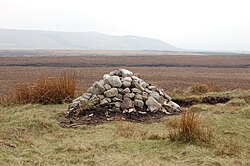
The cairn on Round Loaf on Anglezarke Moor, looking towards Winter Hill
Location map United Kingdom Borough of Chorley.svg
Archaeological site icon (red).svg
Round Loaf
Location in Chorley Borough
Lancashire UK location map.svg
Archaeological site icon (red).svg
Round Loaf
Location in Lancashire
LocationNear Anglezarke and Chorley
Region Lancashire, England
Coordinates 53°39′32.5″N2°32′57.29″W / 53.659028°N 2.5492472°W / 53.659028; -2.5492472 Coordinates: 53°39′32.5″N2°32′57.29″W / 53.659028°N 2.5492472°W / 53.659028; -2.5492472
Type Round barrow
History
Periods Neolithic or Bronze Age
Site notes
Conditionintact

Round Loaf is a late-Neolithic or Bronze Age tumulus on Anglezarke Moor in the West Pennine Moors near Chorley in Lancashire, England. The bowl barrow is a scheduled monument considered to be of national importance. It was first scheduled in March 1954. [1] The structure is aligned between Great Hill and Pikestones.

Contents

Background

Round Loaf is one of 10,000 bowl barrows constructed between the late-Neolithic period and the late-Bronze Age (2400 - 1500 BC). They are funerary monuments in the form of earth or rubble mounds covering single or multiple burials. Some were surrounded by a ditch. Some are in isolated locations as is Round Loaf and some are grouped in cemeteries. They vary in size and regional variations show a range of different burial practices. [1]

Description

Round Loaf occupies a prominent landmark position on Anglezarke Moor. Some erosion has occurred on its summit. It has not been excavated and its archaeology is possibly undisturbed. The ancient monument includes an oval mound measuring 73 metres from north to south and 66 metres from east to west. It is constructed of earth and small stones to a height of from 3.6 to 5.5 metres. Flakes of flint have been found on the mound's summit. [1]

See also

Notes and references

  1. 1 2 3 Historic England, "Round Loaf bowl barrow on Anglezarke Moor (1008904)", National Heritage List for England , retrieved 8 February 2015


Related Research Articles

Tumulus Mound of earth and stones raised over graves

A tumulus is a mound of earth and stones raised over a grave or graves. Tumuli are also known as barrows, burial mounds or kurgans, and may be found throughout much of the world. A cairn, which is a mound of stones built for various purposes, may also originally have been a tumulus.

Arbor Low Neolithic henge monument in England

Arbor Low is a well-preserved Neolithic henge in the Derbyshire Peak District, England. It lies on a Carboniferous Limestone plateau known as the White Peak area. The monument consists of a stone circle surrounded by earthworks and a ditch.

Gallery grave Form of megalithic tomb

A gallery grave is a form of megalithic tomb built primarily during the Neolithic Age in Europe in which the main gallery of the tomb is entered without first passing through an antechamber or hallway. There are at least four major types of gallery grave, and they may be covered with an earthen mound or rock mound.

Round barrow Hemispherical mound of earth and/or stone raised over a burial placed in the middle

A round barrow is a type of tumulus and is one of the most common types of archaeological monuments. Although concentrated in Europe, they are found in many parts of the world, probably because of their simple construction and universal purpose.

Dunkery Hill Summit of Dunkery Hill

Dunkery Beacon at the summit of Dunkery Hill is the highest point on Exmoor and in Somerset, England. It is also the highest point in southern England outside of Dartmoor.

Anglezarke Human settlement in England

Anglezarke is a sparsely populated civil parish in the Borough of Chorley in Lancashire, England. It is an agricultural area used for sheep farming, also site of reservoirs that were built to supply water to Liverpool. The area has a large expanse of moorland with many public footpaths and bridleways. The area is popular with walkers and tourists, it lies in the West Pennine Moors in Lancashire, sandwiched between the moors of Withnell and Rivington, and is close to the towns of Chorley, Horwich and Darwen. At the 2001 census it had a population of 23. At the 2011 Census the population is included within Heapey civil parish. The area was subjected to depopulation after the reservoirs were built.

West Pennine Moors

The West Pennine Moors is an area of the Pennines covering approximately 90 square miles (230 km2) of moorland and reservoirs in Lancashire and Greater Manchester, England. It is a Site of Special Scientific Interest.

Minninglow Archaeological site in Derbyshire, UK

Minninglow is a hill in the Peak District National Park in Derbyshire, located within the White Peak area at grid reference SK209573. Within the clump of trees crowning the hill are a Neolithic chambered tomb and two Bronze Age bowl barrows.

Hob Hursts House

Hob Hurst's House is a Bronze Age barrow on Beeley Moor near Bakewell in Derbyshire. It is unique in that instead of the normal round shape, Hob Hurst's barrow is rectangular. Originally made with 13 stones, only five remain today.

Pikestones

Pikestones is the remains of a Neolithic Burial Cairn, located on Anglezarke moor in Lancashire, England. The site is approximately 150 feet long and 60 feet across at its widest point. It consisted of one burial chamber constructed of large upright slabs, capped by two lintel slabs, forming a chamber of 15 feet long, 3 feet wide and 3 feet high, covered by a huge mound of stones and turves. The cairn was aligned almost exactly North-South, with the burial chamber under the wider northern end. At the northern edge of the cairn, a double wall could be made out, curving inwards to form an entrance to a forecourt.

Hurst Hill

Hurst Hill is a location on Anglezarke Moor, within the West Pennine Moors of Lancashire, England. Despite a modest height of 317 metres (1040 feet), the summit provides excellent views towards the Irish Sea. Of more note, however, is its location between Round Loaf and Pikestones, both of which are Neolithic remnants. It is probable that Hurst Hill were vantage points for the ancient communities. No excavation work has taken place.

Grain Pole Hill is a location on Anglezarke Moor, within the West Pennine Moors of Lancashire, England. Despite a modest height of 285 metres (935 ft), the summit provides excellent views towards the Irish Sea. It is located between Round Loaf and Pikestones, both of which are Neolithic remnants. Hurst Hill is less than half a mile away.

The Bull Ring Neolithic henge monument in Derbyshire

The Bull Ring is a Class II henge that was built in the late Neolithic period near Dove Holes in Derbyshire, England.

Briercliffe Human settlement in England

Briercliffe is a civil parish in the borough of Burnley, in Lancashire, England. It is situated 3 miles (4.8 km) north of Burnley. The parish contains suburbs of Burnley, and the rural area north east of the town. Hamlets in the parish include Cockden, Lane Bottom and in the Extwistle area, the tiny hamlet of Roggerham. According to the United Kingdom Census 2011, the parish has a population of 4,031.

Normanton Down Barrows Barrows in England

Normanton Down is a Neolithic and Bronze Age barrow cemetery located about 0.6 miles (1 km) south of Stonehenge in Wiltshire, England. The burials date from between 2600 and 1600 BC and consist of a Neolithic long barrow and some 40 or more Bronze Age round barrows, sited along the crest of a low ridge.

Cursus Barrows Barrow cemetery in England

The Cursus Barrows is the name given to a Neolithic and Bronze Age round barrow cemetery located mostly south of the western end of the Stonehenge Cursus. The cemetery contains around 18 round barrows scattered along an east-to-west ridge, although some of the mounds are no longer visible. The Cursus Barrows can be seen just north of the route between the Stonehenge Visitor Centre and Stonehenge.

Battlegore Burial Chamber is a Bronze Age burial chamber located in Williton, Somerset. It is composed of three round barrows and possibly a long, chambered barrow. The site was excavated in 1931 by George Gray. The name "Battlegore" comes from this site being attributed to the location of a Danish raid in 918 AD or 988 AD. At least as early as the 14th century, the site was referred to as "Bytelgore", a predecessor of the word "Battlegore". Along with three nearby round barrows it has been scheduled as an ancient monument.

Noon Hill (North West England)

Noon Hill is a hill on the border of the boroughs of Chorley, Blackburn with Darwen and Bolton, in North West England. It is located on Rivington Moor, Chorley and is 380 metres (1,247 ft) high. Part of the West Pennine Moors, it is a popular walking area, and is of significant historical interest. The summit of Noon Hill is home to a Bronze Age burial mound which is listed under the Ancient Monuments and Archaeological Areas Act 1979 as it appears to the Secretary of State to be of national importance.

Priddy Nine Barrows and Ashen Hill Barrow Cemeteries

Priddy Nine Barrows Cemetery and Ashen Hill Barrow Cemetery are a collection of round barrows, dating from the Bronze Age, near Priddy in the English county of Somerset. They are designated as ancient monuments.

Wor Barrow

Wor Barrow is a Neolithic long barrow on Cranborne Chase, about 1 mile (1.6 km) east of Sixpenny Handley in Dorset, England. It is a scheduled monument.