Listed buildings in Rivington

Last updated

Rivington Hall, in Lever Park, Rivington Rivington Hall - geograph.org.uk - 96701.jpg
Rivington Hall, in Lever Park, Rivington

Rivington in the Borough of Chorley, Lancashire, is situated on the edge of the West Pennine Moors, at the foot of Rivington Pike overlooking reservoirs created for Liverpool Corporation Waterworks in the 19th century. [1] There are twenty eight listed buildings within Rivington, [2] two are classified by English Heritage as Grade II*, the rest as Grade II; Rivington has no Grade I Listed buildings. [3] [4]

Contents

Rivington village is a conservation area, designated under section 69 of the Planning (Listed Buildings and Conservation Areas) Act 1990; almost half the houses in the village centre have listed status. [5] Rivington's buildings are varied, reflecting its rural and historic nature, and include former hand-loom weavers' cottages, the church, and the chapel. Locally sourced stone for walls and slate for roofs are the predominant building materials, used for places of worship, the school, houses (including many not listed), and boundary dry stone walls. An exception is Fisher House, a three-storey Georgian rendered building. [6]

Rivington Hall, a former manor house with an imposing red brick Georgian frontage, is a short distance from the village centre. Its barn, and the barn at Great House Farm were renovated and converted by the architect Jonathan Simpson for William Lever in 1904. The barns were used for catering for the early tourist industry, a function they retain today. Farmhouses and their barns scattered outside the village centre, also built in local gritstone, are also listed.

Most of the remaining listed structures are in the listed historic landscape of Lever Park, a country park created for William Lever by Thomas Mawson in the early 20th century, the park includes Rivington Pike summit and the Pike tower, built in 1733 for Robert Andrews. . [7] They include an unfinished replica of Liverpool Castle, overlooking the Lower Rivington Reservoir. Outside the park on the hillside are the terraced gardens, being the remains of Leverhulmes private gardens in his country retreat, once used for sport of shooting. The latter includes the Pigeon Tower, which is a large folly and former dovecote. [8]

The term "listed building", in the United Kingdom, refers to a building or structure designated as being of special architectural, historical, or cultural significance. They are categorised in three grades: Grade I consists of buildings of outstanding architectural or historical interest, Grade II* includes significant buildings of more than local interest and Grade II consists of buildings of special architectural or historical interest. Buildings in England are listed by the Secretary of State for Culture, Media and Sport on recommendations provided by English Heritage, which also determines the grading. [9]

Key

Map all coordinates using: OpenStreetMap  
Download coordinates as: KML
GradeCriteria [9]
II*Particularly important buildings of more than special interest.
IIBuildings of national importance and special interest.

Listed buildings and structures

Name and locationPhotographGradeDateNotes
Rivington Church
53°37′31″N2°34′07″W / 53.6252°N 2.5685°W / 53.6252; -2.5685 (Rivington Church)
Rivington Church.JPG
II1. 1541
2. 1666 (rebuilt)
3. 19th century (restoration)
The church, located in Rivington village is built of irregularly coursed sandstone with quoins and a slate roof. It is a small plain building with a 19th-century gabled porch and an octagonal bell turret with a conical roof and weathervane. [10] [11]
Bellhouse
53°37′31″N2°34′08″W / 53.6252°N 2.5688°W / 53.6252; -2.5688 (Bellhouse)
Bellhouse Rivington Church.JPG
II16th centuryThe bellhouse, being part of the church site, is a small, square, single-storey building with a basement and outside steps. It is built in sandstone with a stone slate roof. It is reputed to have been built to hold a large bell which is now missing. [12]
Great House Barn
53°37′13″N2°33′46″W / 53.6202°N 2.5627°W / 53.6202; -2.5627 (Great House Barn)
Great House Barn - geograph.org.uk - 97628.jpg
II1.16th century
2. 1905 (restoration)
The barn, located within Lever Park is dated 1702, probably from a restoration or rebuilding. It was restored, altered, and enlarged in 1905. It has an exposed oak cruck frame, clad in squared sandstone and stone slate roof. The Tudor-style timber-framed porch and mullion windows are 20th-century additions. [13]
Rivington Hall Barn
53°37′32″N2°33′22″W / 53.6256°N 2.5561°W / 53.6256; -2.5561 (Rivington Hall Barn)
Rivington Hall Barn - geograph.org.uk - 10975.jpg
II1.16th century
2. 1905 (restoration)
The former Tithe barn is the larger of the two converted barns within Lever Park and is of varying build dates, thought to be mainly 16th century and then restored, altered, and enlarged in 1905. It has an oak cruck frame that has been exposed inside. The walls are clad in coursed sandstone, and it has a stone slate roof and mullion windows. [14]
Hamer's Cottage
53°36′28″N2°33′26″W / 53.6078°N 2.5573°W / 53.6078; -2.5573 (Hamer's Cottage)
II1. 17th century or earlier
2. 18th century (altered)
This house is a former farmhouse built of sandstone with quoins and stone slate roof, located at Dryfield Lane, Rivington. Part of the house has cruck frame construction. [15]
Great House Farmhouse and Cottage
53°37′12″N2°33′45″W / 53.6200°N 2.5625°W / 53.6200; -2.5625 (Great House Farmhouse   Cottage)
Rivington Great House Information Centre - geograph.org.uk - 1907033.jpg
II1. 17th century farmhouse
2. 18th century cottage
The farmhouse, built from squared sandstone with quoins with a stone slate roof and mullion windows, dates from the 17th century, it serves as an information centre and location of public toilets for Lever Park. The cottage dates from the 18th century and is built in similar materials. [16] Great House Farm now houses an information centre. [17]
Wilcocks Farmhouse
53°38′07″N2°33′28″W / 53.6353°N 2.5577°W / 53.6353; -2.5577 (Wilcocks Farmhouse)
Willcocks Farm - geograph.org.uk - 130992.jpg
II1. 1670
2. 19th century (extended)
Willcock's is a farmhouse built in coursed sandstone rubble with quoins at the corners, it has a tiled roof with two chimneys, mullion windows, and is dated on the door lintel. [18]
Bradley's Farmhouse
53°37′53″N2°33′41″W / 53.6315°N 2.5614°W / 53.6315; -2.5614 (Bradley's Farmhouse)
II1683Bradley's is a two-storey farmhouse built of sandstone with quoins and a stone slate roof, the date is on the door lintel, it has mullion windows to the second floor. The farm is a small holding of 103 acre. [19] [20]
Barn, East of Bradley's Farmhouse
53°37′54″N2°33′39″W / 53.6317°N 2.5609°W / 53.6317; -2.5609 (Barn, East of Bradley's Farmhouse)
II1737The barn, which has a shippon or cow shed, is built in sandstone with a stone slate roof. There is an owl hole above the loading door to the loft. [21]
Moses Cocker's Farmhouse
53°37′57″N2°32′58″W / 53.6325°N 2.5494°W / 53.6325; -2.5494 (Moses Cocker's Farmhouse)
Moses Cocker's Farmhouse.jpg
II1693Moses Cocker's is a former farmhouse and built of coursed rubble sandstone with quoins, a stone slate roof with gable coping and it is dated on the door lintel. The building underwent alterations in 2015 to become a residence, it had been bought by United Utilities who retained the land after selling the building. [22] [23]
Rivington Hall
53°37′31″N2°33′22″W / 53.6252°N 2.5562°W / 53.6252; -2.5562 (Rivington Hall)
Rivington Hall - geograph.org.uk - 96701.jpg
II*1. 1694
2. 1700
3. 1774
Rivington Hall, once the museum within Lever Park is an old manor house, the oldest part of which, at the rear, is dated 1694 and replaced a 15th-century timber-framed house. The front, rebuilt in 1774, has two storeys in classical Georgian style with five bays, a central doorway, sash windows, pediment and parapet. It is a private residence. [24]
Rivington Unitarian Chapel
53°37′33″N2°33′56″W / 53.6259°N 2.5656°W / 53.6259; -2.5656 (Rivington Unitarian Chapel)
Unitarian Chapel, Rivington.JPG
II*1703The chapel, located in the village is a rectangular sandstone building with a hexagonal gable end bellcote and stone slate roof. Inside it retains its old box pews and has a five-sided pulpit. [25]
Rivington Pike Tower
53°37′10″N2°32′29″W / 53.6194°N 2.5413°W / 53.6194; -2.5413 (Rivington Pike Tower)
Rivington pike.jpg
II1733The Pike tower, built of gritstone, sits on the hill summit of Rivington Pike, which is a detached part of Lever Park, built as a hunting lodge, the foundation stones are from an ancient beacon. It is approximately 5 by 5 metres (16 by 16 ft) square and 7 metres high. Original features such as its cellar, stone flagged floor, chimney and fireplace have long since been removed. Its datestone went missing during the 1970s in a period of significant neglect. [26]
Mounting block in school yard
53°37′28″N2°34′04″W / 53.6244°N 2.5679°W / 53.6244; -2.5679 (Mounting Block)
Mounting Block, Rivington.jpg
II18th century (possibly)The mounting block is a circular sandstone platform, with a stone post in the centre and two steps. It is in the old Rivington Grammar School yard within the village. [27]
Fisher House
53°37′31″N2°33′54″W / 53.6253°N 2.5649°W / 53.6253; -2.5649 (Fisher House)
Fisher House, Rivington.jpg
II1763The building sits in a secluded and private position within the village and is a three-storey stucco on brick house with stone dressings and stone slate roof with gable chimneys, the door has a fanlight and the house has sash windows. Originally built in 1763 for the Reverend John Fisher and later becoming a Temperance Hotel before reverting to a private residence. [28] [29]
Wilkinson's and attached cottage
53°37′30″N2°33′55″W / 53.6249°N 2.5652°W / 53.6249; -2.5652 (Wilkinson's and Cottage Attached)
Wilkinsons.JPG
II1. 1788
2. 19th century
The pair of cottages is built in sandstone with slate roofs, one has horizontal three light windows, the other has two higher storeys with sash windows. [30]
Loggia c. 70 metres west of Pigeon tower in Lord Leverhulme's Terraced Gardens
53°37′27″N2°32′50″W / 53.6242°N 2.5473°W / 53.6242; -2.5473 (Loggia in Terraced Gardens)
Loggia, Rivington.jpg
II1906The remains of a loggia with arches overlooking a former boating lake in the Terraced Gardens, a former private gardens designed by Thomas Mawson for William Lever. [31]
Two archways in Lord Leverhulme's Terraced Gardens
53°37′24″N2°32′50″W / 53.6233°N 2.5471°W / 53.6233; -2.5471 (Two Archways in Lord Leverhulme's Terraced Gardens)
Archways, Rivington.jpg
II1906These archways are an intact element of the remains of private gardens designed by Thomas Mawson for Leverhulme's Rivington Bungalow. [32]
Pigeon Tower north east corner of Lord Leverhulme's Terraced Garden
53°37′27″N2°32′47″W / 53.6243°N 2.5463°W / 53.6243; -2.5463 (Pigeon Tower)
Pigeon Tower - geograph.org.uk - 303693.jpg
II1910The Pigeon Tower was built in gritstone with four storeys, each a single room., on the boundary of the Terraced Gardens. It has a steeply pitched roof and a corbelled chimney. On the west side is a semi-circular stair turret with a conical roof. The fourth storey, a sitting room, has four light mullioned windows on two sides. The second and third storeys are a dovecote. On the west wall are square pigeon holes with perching ledges. [33]
Seven Arch Bridge in Lord Leverhulme's Terraced Gardens
53°37′25″N2°32′55″W / 53.6235°N 2.5485°W / 53.6235; -2.5485 (Seven Arch Bridge in Lord Leverhulme's Terraced Gardens)
7 Arch Bridge - geograph.org.uk - 96653.jpg
II1910The bridge, crossing over Royton Road within the Terraced Gardens has random sandstone rubble walls and round stone slate arches and parapets. The large round archway is crossed by six small arches. It carries a footpath over an old roadway. In memoirs recalling after dinner stories the second viscount Leverhulme thought the bridge design was influenced by one in Nigeria, however no similar bridge exists there and is more likely the design is based on the Pont du Gard, France. [34]
Rivington Castle
53°36′45″N2°33′47″W / 53.6125°N 2.5630°W / 53.6125; -2.5630 (Rivington Castle)
Liverpool Castle - geograph.org.uk - 226.jpg
II1912 to 1925The replica smaller schale ruin of Liverpool Castle is a folly built for Lord Leverhulme in gritstone close to the Lower Rivington Reservoir as a feature of Lever Park, the build was never completed, stopping on Leverhulmes death in 1925, the current owner. United Utilities had authorised Rivington Heritage Trust to carry out significant alterations on its stonework in 2012. [35]

Related Research Articles

Rivington Pike Hill in Lancashire, England

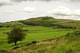
Rivington Pike is a hill on Winter Hill, part of the West Pennine Moors at Rivington, Chorley in Lancashire, England. The nearest towns are Adlington and Horwich. The land and building are owned and managed by Chorley Council. The Pike Tower is a prominent local landmark and is located at the summit, it is part of Lever Park. The area is popular with hill walkers and for mountain biking.

Anderton, Lancashire Human settlement in England

Anderton is a civil parish in the Borough of Chorley in Lancashire, England. It is now a suburb of Adlington, 5 miles (8 km) northwest of Bolton. Within its boundaries are the Rivington Reservoirs. Grimeford village is in the parish. In 2001, the parish had a population of 1,206, increasing to 1,316 at the 2011 census.

Rivington Village in Lancashire, England

Rivington is a village and civil parish of the Borough of Chorley, Lancashire, England, occupying 2,538 acres. It is about 6 miles (9.7 km) southeast of Chorley and about 8+12 miles (13.7 km) northwest of Bolton. Rivington is a rural area consisting primarily of agricultural grazing land, moorland, with hill summits including Rivington Pike and Winter Hill within the West Pennine Moors. The area has a thriving tourist industry centred around reservoirs created to serve Liverpool in the Victorian era and Lever Park created as a public park by William Lever at the turn of the 20th century, with two converted barns, a replica of Liverpool Castle and open countryside. Rivington and its village had a population of 109 at the 2011 Census.

Great House Barn Barn in Lancashire, England

Great House Barn is a 16th-century barn and Listed building in Rivington, Lancashire, England. Built as a tithe barn it is believed to be one of the oldest of its type in the county and is a Grade II listed building.

Rivington Hall Barn Barn in Lancashire, England

Rivington Hall Barn adjoins Rivington Hall in Rivington, Lancashire, near Chorley and Bolton. The Tithe barn foundation stones support a Medieval cruck construction and possibly date to the between the 9th and 15th centuries. The structure was restored, altered and enlarged in 1905 by Jonathan Simpson for Lord Leverhulme. It is a Grade II Listed building.

Anderton is a civil parish in the Borough of Chorley, Lancashire, England. It contains twelve buildings that are recorded in the National Heritage List for England as designated listed buildings, all of which are listed at Grade II. This grade is the lowest of the three gradings given to listed buildings and is applied to "buildings of national importance and special interest". The parish is mainly rural, with its northern part containing residential areas linking with the town of Adlington. The listed buildings reflect the agricultural history of the parish, with nine of them being farmhouses or farm buildings. The other listed buildings are a portion of a medieval cross, the remains of a set of stocks, and a house from the early 20th century.

Listed buildings in Lymm

In the English civil parish of Lymm, there are 55 buildings that are recorded in the National Heritage List for England as designated listed buildings. Of these, one is classified as Grade I and one as Grade II*; the remainder are at Grade II. Lymm is in the borough of Warrington and the ceremonial county of Cheshire. In the early 16th century, the civil parish was a prosperous agricultural area, divided into two manors, Lymm and Oughtrington. The Grade-II*-listed Lymm Hall, the oldest listed building in the civil parish, dates from the late 16th century and occupies the site of a medieval building which was the manorial seat. The largest settlement in the civil parish is Lymm, which has expanded into a small town whilst retaining its village centre. Several other small settlements within the parish remain separate, including Oughtrington; Oughtrington Hall dates from around 1810.

Alderley Edge is a civil parish in Cheshire East, England. It contains 30 buildings that are recorded in the National Heritage List for England as designated listed buildings. Of these, one is listed at Grade I, the highest grade, one is listed at Grade II*, the middle grade, and the others are at Grade II. The parish contains the village of Alderley Edge, which became a dormitory settlement for workers in Manchester following the arrival of the railway in 1842. Included in the listed buildings are mansions for the more wealthy businessmen. In the countryside surrounding the village are listed houses, cottages, and farm buildings. Within the village, in addition to houses, the listed buildings include a former railway hotel, churches, a school, a bank, a drinking fountain, a war memorial, and a garage.

Briercliffe is a civil parish in the borough of Burnley, Lancashire, England. The parish contains 21 buildings that are recorded in the National Heritage List for England as designated listed buildings. Of these, one is listed at Grade I, the highest of the three grades, two at Grade II*, the middle grade, and the others are at Grade II, the lowest grade.

Cliviger is a civil parish in the borough of Burnley, Lancashire, England. The parish contains 22 listed buildings that are recorded in the National Heritage List for England. Of these, two are listed at Grade II*, the middle grade, and the others are at Grade II, the lowest grade. Apart from small settlements, the parish is rural, and most of the listed buildings are or have been farmhouses, farm buildings, and associated structures. Also in the parish are large houses, a parish church, the base of a cross, a public house, two war memorials, and two boundary stones.

Worsthorne-with-Hurstwood is a civil parish in the borough of Burnley, Lancashire, England. The parish contains 22 buildings that are recorded in the National Heritage List for England as designated listed buildings. Of these, four are listed at Grade II*, the middle grade, and the others are at Grade II, the lowest grade. Apart from the village of Worsthorne and the settlement of Hurstwood, the parish is rural. Most of the listed buildings are farmhouses, or originated as farmhouses or farm buildings. Other listed buildings include large houses and associated structures, a row of former back-to-back cottages, a church, and a telephone kiosk.

Heskin is a civil parish in the Borough of Chorley, Lancashire, England. It contains 17 buildings that are recorded in the National Heritage List for England as designated listed buildings. Of these, one is listed at Grade I, the highest of the three grades, one is at Grade II*, the middle grade, and the others are at Grade II, the lowest grade. The parish is almost completely rural, and most of the listed buildings are, or originated as, farmhouses and farm buildings. The other listed buildings are large houses and associated structures, and a cottage.

Wheelton is a civil parish in the Borough of Chorley, Lancashire, England. It contains twelve buildings that are recorded in the National Heritage List for England as designated listed buildings, all of which are listed at Grade II. This grade is the lowest of the three gradings given to listed buildings and is applied to "buildings of national importance and special interest". Apart from the villages of Wheelton and Higher Wheelton, the parish is rural, and many of the listed building are, or originated as, farmhouses and farm buildings. The Leeds and Liverpool Canal passes through the parish, and associated with this are three listed bridges. The other listed buildings are two sets of weavers' cottages.

Withnell is a civil parish in the Borough of Chorley, Lancashire, England. It contains 19 buildings that are recorded in the National Heritage List for England as designated listed buildings, all of which are listed at Grade II. This grade is the lowest of the three gradings given to listed buildings and is applied to "buildings of national importance and special interest". Apart from the village of Withnell, the parish is mainly rural. Many of the listed buildings are, or originated as, farmhouses or farm buildings. The Leeds and Liverpool Canal runs through the parish, and six of the bridges crossing it are listed. The other listed buildings include cottages, large houses, and a set of stocks.

Chorley is a market town in the borough of Chorley, Lancashire, England. The town itself is unparished, and this list contains the listed buildings in the unparished area. Outside the town are parished areas, and each of these has a separate list for its listed buildings. The unparished area contains 53 buildings that are recorded in the National Heritage List for England as designated listed buildings. Of these, one is listed at Grade I, the highest of the three grades, five are at Grade II*, the middle grade, and the others are at Grade II, the lowest grade.

Borwick is a civil parish in Lancaster, Lancashire, England. It contains 27 listed buildings that are recorded in the National Heritage List for England. Of these, three are listed at Grade I, the top grade, and the others are at Grade II, the lowest of the three grades of listing. The parish contains the village of Borwick, and is otherwise rural. The most important building in the parish is Borwick Hall; this and a number of associated buildings and structures are listed. The Lancaster Canal passes through the parish, and associated with it are five listed bridges and an aqueduct. The other listed buildings include houses, farm buildings, bridges over the River Keer, a church, a milestone, and a telephone kiosk.

Over Wyresdale is a civil parish in Lancaster, Lancashire, England. It contains 53 buildings that are recorded in the National Heritage List for England as designated listed buildings. Of these, one is at Grade II*, the middle grade, and the others are at Grade II, the lowest grade.

Yealand Redmayne is a civil parish in Lancaster, Lancashire, England. It contains 15 buildings that are recorded in the National Heritage List for England as designated listed buildings. Of these, one is at Grade II*, the middle grade, and the others are at Grade II, the lowest grade. The parish contains the village of Yealand Redmayne, and is otherwise rural. Most of the listed buildings are houses, farmhouses and farm buildings, many of them on the main street of the village. The Lancaster Canal passes through the parish, and two bridges crossing it are listed, together with a milestone on its towpath.

Goosnargh is a civil parish in the City of Preston, Lancashire, England. It contains 49 listed buildings that are recorded in the National Heritage List for England. Of these, four are at Grade II*, the middle grade, and the others are at Grade II, the lowest grade. The parish contains the villages of Inglewhite and Whitechapel, and part of the village of Goosnargh, but is otherwise completely rural. The listed buildings are mainly houses and associated structures, farmhouses, and farm buildings. The other listed buildings include churches, cross bases, sundials, a public house, and a school.

Todmorden is a market town and civil parish in the metropolitan borough of Calderdale, West Yorkshire, England. It contains over 300 listed buildings that are recorded in the National Heritage List for England. Of these, two are listed at Grade I, the highest of the three grades, eleven are at Grade II*, the middle grade, and the others are at Grade II, the lowest grade. This list contains the listed buildings in the more outlying areas of the parish, namely those along Rochdale Road to the south of its junction with Bacup Road, including the settlement of Walsden and Warland, along Bacup Road, including Clough Foot, and the surrounding outlying rural and moorland areas, including the settlements of Mankinholes and Lumbutts. The listed buildings in the inner area are in Listed buildings in Todmorden.

References

  1. Rivington Township Boundaries, GenUKI, archived from the original on 6 June 2011, retrieved 6 June 2010
  2. "Listed Buildings in Rivington, Chorley, Lancashire". British Listed Buildings. British Listed Buildings. Retrieved 9 August 2019.
  3. Listed Buildings in Rivington, British Listed Buildings Online, archived from the original on 20 November 2011, retrieved 12 June 2010
  4. Chorley Borough Council Listed Buildings, Chorley Council, archived from the original on 8 June 2011, retrieved 12 June 2010
  5. Map of Conservation Area (PDF), Chorley Council, archived from the original on 8 June 2011, retrieved 7 June 2010
  6. Rivington Conservation Area Appraisal and Management Proposals (PDF), Chorley Council, archived from the original on 8 June 2011, retrieved 17 June 2010
  7. Waymark 2009 , pp. 77–81
  8. Area: Rivington Gardens, Parks and Gardens UK, archived from the original on 11 March 2012, retrieved 17 June 2010
  9. 1 2 "Listed Buildings". English Heritage. 2010. Archived from the original on 22 December 2012. Retrieved 19 August 2011.
  10. Historic England, "Church of the Holy Trinity (1164938)", National Heritage List for England , retrieved 25 June 2011
  11. Rivington Church, GenUKI, archived from the original on 11 November 2010, retrieved 3 June 2010
  12. Historic England, "Bellhouse circa 10 metres west of Church of Holy Trinity (1165054)", National Heritage List for England, retrieved 25 June 2011
  13. Historic England, "Great House Barn (1362125)", National Heritage List for England, retrieved 25 June 2011
  14. Historic England, "Rivington Hall Barn (1072510)", National Heritage List for England, retrieved 25 June 2011
  15. Historic England, "Hamers Cottage (Marked on OS map as Hamers Farm) Rivington Lane (1165035)", National Heritage List for England, retrieved 25 June 2011
  16. Historic England, "Great House Farmhouse and Cottage (1072509)", National Heritage List for England, retrieved 25 June 2011
  17. Rivington Information Centre, United Utilities, archived from the original on 14 April 2009, retrieved 20 June 2010
  18. Historic England, "Wilcocks Farmhouse (1072507)", National Heritage List for England, retrieved 25 June 2011
  19. Kelly, Robert (10 February 2021). "Couple looking to make grow their 'starter farm' in Rivington" . Retrieved 22 November 2021.
  20. Historic England, "Bradley's Farmhouse (1072511)", National Heritage List for England, retrieved 25 June 2011
  21. Historic England, "Barn circa 50 metres east of Bradley's Farmhouse, Sheep House Lane (1317492)", National Heritage List for England, retrieved 25 June 2011
  22. Historic England, "Moses Cocker's Farmhouse (1164894)", National Heritage List for England, retrieved 25 June 2011
  23. "15/00975/FUL". Chorley Council. Chorley Council. Retrieved 1 November 2021.
  24. Historic England, "Rivington Hall (1165012)", National Heritage List for England, retrieved 25 June 2011
  25. Historic England, "Unitarian Chapel (1362126)", National Heritage List for England, retrieved 25 June 2011
  26. Historic England, "Rivington Pike Tower at SD 642 137 (1072505)", National Heritage List for England, retrieved 25 June 2011
  27. Historic England, "Mounting Block in School Yard circa 15 metres west of Rivington School (1362124)", National Heritage List for England, retrieved 25 June 2011
  28. O'Kane, Simone (8 December 2020). "Stunning property with snooker room and once home to a Lancs poet could be yours for £1m" . Retrieved 22 November 2021.
  29. Historic England, "Fisher House (1072508)", National Heritage List for England, retrieved 25 June 2011
  30. Historic England, "Wilkinson's and cottage attached to right (1164996)", National Heritage List for England, retrieved 25 June 2011
  31. Historic England, "Loggia circa 70 metres west of Pigeon Tower in Lord Leverhulme's Terraced Gardens at SD 639 143 (1317582)", National Heritage List for England, retrieved 25 June 2011
  32. Historic England, "Two archways and associated retaining walls to two stone staircases at north corner of tennis lawn in Leverhulme's Terraced Gardens at SD 639 142 (1362123)", National Heritage List for England, retrieved 25 June 2011
  33. Historic England, "Pigeon Tower at north east corner of Lord Leverhulme's Terraced Gardens at SD 639 143 (1317613)", National Heritage List for England, retrieved 25 June 2011
  34. Historic England, "Lever Bridge in Lord Leverhulme's Terraced Gardens at SD 638 142 (1072506)", National Heritage List for England, retrieved 25 June 2011
  35. Historic England, "Rivington Castle (1164955)", National Heritage List for England, retrieved 25 June 2011

Bibliography

Further reading