
The Lancaster Canal is a canal in North West England, originally planned to run from Westhoughton in Lancashire to Kendal in south Cumbria. The section around the crossing of the River Ribble was never completed, and much of the southern end leased to the Leeds and Liverpool Canal, of which it is now generally considered part.

The Leeds and Liverpool Canal is a canal in Northern England, linking the cities of Leeds and Liverpool.
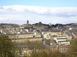
Colne is a market town and civil parish in the Borough of Pendle in Lancashire, England. The town is 3 miles (5 km) northeast of Nelson, 6 miles (10 km) northeast of Burnley and 25 mi (40 km) east of Preston.

The Calder Valley line is a railway route in Northern England between the cities of Leeds and Manchester as well as the seaside resort of Blackpool. It is the slower of the two main rail routes between Leeds and Manchester, and the northernmost of the three main trans-Pennine routes.

The Liverpool and Bury Railway was formed by an Act in 1845 to link Liverpool and Bury via Kirkby, Wigan and Bolton, the line opening on 20 November 1848. The line became the Lancashire and Yorkshire Railway's main line between Liverpool, Manchester and Yorkshire. Most of it is still open.

Foulridge is a village and civil parish in Pendle, Lancashire, close to the border with North Yorkshire in England. It is situated just beyond Colne, on the route from the M65 to Skipton, and is an important stopping point on summit pound of the Leeds and Liverpool Canal, just before it enters the Foulridge Tunnel. Noyna Hill, a well known local landmark, sits 1 mile (1.6 km) east of the village.

The Foulridge Tunnel is a canal tunnel on the Leeds and Liverpool Canal in Foulridge, Lancashire. Also known as the Mile Tunnel, Foulridge is 1,630 yards long and was built by Samuel Fletcher, following Robert Whitworth's 1789 survey. The tunnel is the longest in the country to allow passage of canoes and kayaks.

Altham is a village and civil parish in the Borough of Hyndburn, in Lancashire, England. The village is 4 miles (6.4 km) west of Burnley, 3 miles (4.8 km) north of Accrington, and 2 miles (3.2 km) north-east of Clayton-le-Moors, and is on the A678 Blackburn to Burnley road.

Rishton is a town in the Hyndburn district of Lancashire, England, about 2 miles (3 km) west of Clayton-le-Moors and 4 miles (6 km) north east of Blackburn. It was an urban district from about 1894 to 1974. The population at the census of 2011 was 6,625.

The River Calder is a major tributary of the River Ribble in Lancashire, England, and is around 20 miles (32 km) in length.

The Lancaster Canal Tramroad, also known as the Walton Summit Tramway or the Old Tram Road, was a British plateway, completed in 1803, to link the north and south ends of the Lancaster Canal across the Ribble valley, pending completion of the canal. The canal link was never constructed.

The North Pennine Ring is a canal ring which crosses the Pennines between Manchester, Leeds and Castleford. It follows parts of five canals, and shares much of its route with the Outer Pennine Ring, which uses a different route for the southern crossing of the Pennines.

The Outer Pennine Ring is an English canal ring which crosses the Pennines between Manchester, Leeds and Castleford. Its route follows parts of eight canals, and includes the longest canal tunnel in England. The ring was completed in 2001, with the opening of the Huddersfield Narrow Canal. Much of the route is shared with the North Pennine Ring, which crosses the Pennines by a different route on the southern leg.

Hapton is a village and civil parish in the Borough of Burnley in Lancashire, England, 3 miles (4.8 km) west of Burnley, with a railway station on the East Lancashire Line. At the United Kingdom Census 2011, it had a population of 1,979.

The Haslingden Canal was a proposed canal link between the Bury arm of the Manchester Bolton & Bury Canal in Greater Manchester, England, and the Leeds and Liverpool Canal in Accrington, England, passing through Haslingden. 53°42′N2°18′W Authorised by an Act of Parliament in 1794, the canal was not built.

The Weavers' Triangle is an area of Burnley in Lancashire, England consisting mostly of 19th-century industrial buildings at the western side of town centre clustered around the Leeds and Liverpool Canal. The area has significant historic interest as the cotton mills and associated buildings encapsulate the social and economic development of the town and its weaving industry. From the 1980s, the area has been the focus of major redevelopment efforts.
Livesey is a civil parish in Blackburn with Darwen, Lancashire, England. It contains seven buildings that are recorded in the National Heritage List for England as designated listed buildings, all of which are listed at Grade II. This grade is the lowest of the three gradings given to listed buildings and is applied to "buildings of national importance and special interest". Originally a rural area, the two oldest listed buildings were farmhouses. The Leeds and Liverpool Canal was built through the parish and, associated with this, are a listed bridge and an aqueduct. The parish, which includes the village of Feniscowles and the district of Cherry Tree, later became partly absorbed by the growing population of Blackburn. The listed buildings not noted above are a house, later used as offices, a church, and a vicarage.
Foulridge is a civil parish in Pendle, Lancashire, England. It contains 18 listed buildings that are recorded in the National Heritage List for England. Of these, two are at Grade II*, the middle grade, and the others are at Grade II, the lowest grade. The parish contains the village of Foulridge, and is otherwise rural. Most of the listed buildings are houses, farmhouses, and farm buildings. The Leeds and Liverpool Canal runs through the parish where it enters the Foulridge Tunnel. The entrance to the tunnel is listed, as are three bridges crossing the canal, and other structures associated with it.

The Burnley Embankment is an embankment carrying the Leeds and Liverpool Canal across the Calder and Brun valleys in Burnley, Lancashire. Also known as the Straight Mile, the embankment is 1,256 yards long and the canal runs up to 60 feet (18 m) above the valley floor. The structure was chosen as one of the original Seven Wonders of the Waterways, and has been awarded a Red Wheel by the Transport Trust.
The Seven Wonders of the Waterways is a list of landmarks on the navigable waterways of the United Kingdom. The list was originally compiled in 1946 by Robert Aickman, co-founder of the Inland Waterways Association (IWA), at a time when the waterways network was largely derelict. Today, the Canal & River Trust—formerly British Waterways—has jurisdiction over all of the sites except for the Barton Swing Aqueduct, which is owned and operated by the Bridgewater Canal Company.


