
West Yorkshire is a metropolitan and ceremonial county in the Yorkshire and the Humber region of England. It borders North Yorkshire to the north and east, South Yorkshire and Derbyshire to the south, Greater Manchester to the south-west, and Lancashire to the west. The city of Leeds is the largest settlement.

Batley is a market town in the Kirklees district, in West Yorkshire, England, south-west of Leeds, north-west of Wakefield and Dewsbury, south-east of Bradford and north-east of Huddersfield, in the Heavy Woollen District. In 2011, the population was 48,730.

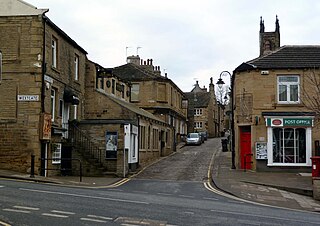
Gomersal is a town in Kirklees in West Yorkshire, England. It is south of Bradford, south west of Leeds. east of Cleckheaton and north of Heckmondwike. It is close to the River Spen and forms part of the Heavy Woollen District.

Guiseley is a town in metropolitan borough of the City of Leeds, West Yorkshire, England. Historically part of the West Riding of Yorkshire, it is situated south of Otley and Menston and is now a north-western suburb of Leeds.

Cleckheaton is a town in the Metropolitan Borough of Kirklees, West Yorkshire, England. Historically part of the West Riding of Yorkshire, it is situated south of Bradford, east of Brighouse, west of Batley and south-west of Leeds. It is at the centre of the Spen Valley and was the major town in the former borough of Spenborough. Cleckheaton has a history as a mill town and forms part of the Heavy Woollen District.

Kirklees is a metropolitan borough of West Yorkshire, England. The borough comprises the ten towns of Batley, Birstall, Cleckheaton, Dewsbury, Heckmondwike, Holmfirth, Huddersfield, Meltham, Mirfield and Slaithwaite. It is governed by Kirklees Council. Kirklees had a population of 422,500 in 2011; it is the third-largest metropolitan district in England by area, behind Doncaster and Leeds.

Hartshead is a village in the Kirklees district of West Yorkshire, England, 3.7 miles (6 km) west of Dewsbury and near to Hartshead Moor.
Honley is a village in the Holme Valley civil parish in Kirklees, West Yorkshire, England. Historically part of the West Riding of Yorkshire, it is situated near to Holmfirth and Huddersfield, and on the banks of the River Holme. According to the 2011 Census it had a population of 6,474, a growth of 577 from the 2001 Census

Thornton is a village and former civil parish, within the metropolitan borough of the City of Bradford, in West Yorkshire, England. It lies 6 miles (9.7 km) to the west of the city centre of Bradford, and together with neighbouring Allerton, had a total resident population in 2001 of 15,004, increasing to 17,276 in 2011 and 18,520 in 2021. Its most famous residents were the Brontës.

Batley and Spen was a constituency in the House of Commons of the UK Parliament. The most recent MP was Kim Leadbeater, a Labour politician, elected in a 2021 by-election by a 323-vote margin. The seat had returned Labour MPs since the 1997 general election.

Liversedge is an industrial town in the Metropolitan Borough of Kirklees, West Yorkshire, England. Historically part of the West Riding of Yorkshire, Liversedge lies between Cleckheaton and Heckmondwike. The Kirklees ward is now called Liversedge and Gomersal with a population at the 2011 Census of 19,420. Liversedge forms part of the Heavy Woollen District and was historically part of the parish of Birstall.
Birstall is a market and mill town in the metropolitan borough of Kirklees, West Yorkshire, England. It is part of the Birstall and Birkenshaw ward, which had a population of 16,298 at the 2011 census. Historically in the West Riding of Yorkshire, and part of the Heavy Woollen District, Birstall is approximately 6 miles (10 km) south-west of Leeds and situated close to the M62 motorway. The town is situated between Leeds, Bradford, Huddersfield and Wakefield.
Spenborough was, from 1915 to 1974, a local government district in the administrative county of Yorkshire, West Riding, England.

Spen Valley is a parliamentary constituency in the valley of the River Spen in the West Riding of Yorkshire. It returned one Member of Parliament (MP) to the House of Commons of the Parliament of the United Kingdom.

Drub is a hamlet in the Kirklees district, in the county of West Yorkshire, England. It is located between Cleckheaton, Birkenshaw, and Gomersal and is considered part of the latter. The name "Drub" derives from rubbish found in coal, was transported which was the former function of Drub Lane as a thoroughfare.

The Leeds, Bradford and Halifax Junction Railway (LB&HJR) was an English railway company. It built a line between Bradford and Leeds, and had running powers over the Lancashire and Yorkshire Railway to Halifax. It opened its main line in 1854 and later built a number of branch lines.

Bierley is a former township in the West Riding of Yorkshire whose name now mainly refers to a neighbourhood in the Tong ward of the City of Bradford, West Yorkshire, England.

The Spen Valley Line was a railway that connected Mirfield with Low Moor through the Spen Valley in West Yorkshire, England. Opened up by the Lancashire and Yorkshire Railway in 1847, with full opening to Low Moor in 1848, the line served a busy industrial and textile area and allowed a connection for trains between Huddersfield and Bradford. The line was absorbed by the London & North Western Railway, the London Midland and Scottish Railway (LMS) and British Railways on Nationalisation. A separate link between Heckmondwike Central and Thornhill that opened later and was known as the Ravensthorpe Branch, allowed through running to Wakefield and beyond. The line was closed down to passengers in 1965 with freight continuing sporadically until 1981. A Spur onto the former Leeds New Line from the Ravensthorpe Branch kept the very southern end open until the late 1980s. The majority of the route is now the Spen Valley Greenway cycle path.
Stansfield is a place and township in the civil parish of Todmorden and Metropolitan Borough of Calderdale, in West Yorkshire, England, which gave its name to Stansfield Hall, Stansfield Hall Railway Station, and an electoral ward in Todmorden, Calderdale.


