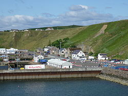
Scrabster

Last updated

Scrabster
Scrabster2009-2.jpg
Scrabster Harbour
Caithness UK location map.svg
Red pog.svg
Scrabster
Location within the Caithness area
OS grid reference ND099701
Council area
Lieutenancy area
Country Scotland
Sovereign state United Kingdom
Post town THURSO
Postcode district KW14
Dialling code 01847
Police Scotland
Fire Scottish
Ambulance Scottish
UK Parliament
Scottish Parliament
List of places
UK
Scotland
58°36′35″N3°33′09″W / 58.609722°N 3.5525°W / 58.609722; -3.5525

Scrabster (Scots : Scraibster, [1] Scottish Gaelic : Sgrabastair/Sgrabstal) [2] is a small settlement on Thurso Bay in Caithness on the north coast of Scotland. It is some 1+12 miles (2.4 km) from Thurso, 22+12 miles (36.2 km) from Wick, 112 miles (180 km) from Inverness and 271.7 miles (437.2 km) from Edinburgh. Scrabster Harbour is an important port for the Scottish fishing industry. [3]

Contents

During the Second World War, munitions were ferried to Scapa Flow from Scrabster harbour aboard the 40 ft (12.2 m) pilot cutter Mermaid (registered in King's Lynn and built in 1908), skippered by Antony Bridges. [4]

Transport

The NorthLink ferry (MV Hamnavoe) leaves regularly from Scrabster for Stromness in Orkney. Smyril Line operated a weekly service to the Faroe Islands in the summer months, but this was discontinued in 2008. [5]

The nearest railway line is the Far North Line, connecting Thurso to Inverness.

Notable people

Related Research Articles

<span class="mw-page-title-main">A9 road (Scotland)</span> Major road in Scotland

The A9 is a major road in Scotland running from the Falkirk council area in central Scotland to Scrabster Harbour, Thurso in the far north, via Stirling, Bridge of Allan, Perth and Inverness. At 273 miles (439 km), it is the longest road in Scotland and the fifth-longest A-road in the United Kingdom. Historically it was the main road between Edinburgh and John o' Groats, and has been called the spine of Scotland. It is one of the three major north–south trunk routes linking the Central Belt to the Highlands – the others being the A82 and the A90.

<span class="mw-page-title-main">Thurso</span> Town in Scotland

Thurso is a town and former burgh on the north coast of the Highland council area of Scotland. Situated in the historical County of Caithness, it is the northernmost town on the island of Great Britain. From a latitudinal standpoint, Thurso is located further north than the southernmost point of Norway and in addition lies more than 500 miles (800 km) north of London.

<span class="mw-page-title-main">Caithness</span> Historic county in northern Scotland

Caithness is a historic county, registration county and lieutenancy area of Scotland.

<span class="mw-page-title-main">Helmsdale</span> Human settlement in Scotland

Helmsdale is a village on the east coast of Sutherland, in the Highland council area of Scotland. The modern village was planned in 1814 to resettle communities that had been removed from the surrounding straths as part of the Highland Clearances.

<span class="mw-page-title-main">Highland Railway</span> Former British railway company

The Highland Railway (HR) was one of the smaller British railways before the Railways Act 1921, operating north of Perth railway station in Scotland and serving the farthest north of Britain. Based in Inverness, the company was formed by merger in 1865, absorbing over 249 miles (401 km) of line. It continued to expand, reaching Wick and Thurso in the north and Kyle of Lochalsh in the west, eventually serving the counties of Caithness, Sutherland, Ross & Cromarty, Inverness, Perth, Nairn, Moray and Banff. Southward it connected with the Caledonian Railway at Stanley Junction, north of Perth, and eastward with the Great North of Scotland Railway at Boat of Garten, Elgin, Keith and Portessie.

<span class="mw-page-title-main">Kyle of Lochalsh</span> Human settlement in Scotland

Kyle of Lochalsh is a village in the historic county of Ross & Cromarty on the northwest coast of Scotland, located around 55 miles (90 km) west-southwest of Inverness. It is located on the Lochalsh peninsula, at the entrance to Loch Alsh, opposite the village of Kyleakin on the Isle of Skye. A ferry used to connect the two villages until it was replaced by the Skye Bridge, about a mile (2 km) to the west, in 1995.

<span class="mw-page-title-main">Dornoch Firth</span> Scottish firth

The Dornoch Firth is a firth on the east coast of Highland, in northern Scotland. It forms part of the boundary between Ross and Cromarty, to the south, and Sutherland, to the north. The firth is designated as a national scenic area, one of 40 such areas in Scotland. The national scenic area covers 15,782 ha in total, of which 4,240 ha is the marine area of the firth below low tide. A review of the national scenic areas by Scottish Natural Heritage in 2010 commented:

By comparison with other east coast firths the Dornoch Firth is narrow and sinuous, yet it exhibits within its compass a surprising variety of landscapes. It is enclosed by abrupt rounded granitic hills clad in heather moor and scree, their Gaelic names of cnoc, meall and creag giving the clue to their character. Their lower slopes are frequently wooded, oakwoods being a noticeable feature of the area, but with other deciduous and coniferous species represented in plantations which vary from the policy plantings of Skibo Castle to the pines of the Struie Forest.

<span class="mw-page-title-main">Lairg</span> Village in Sutherland, Scotland

Lairg is a village and parish in Sutherland, Scotland. It has a population of 891 and is at the south-eastern end of Loch Shin.

<span class="mw-page-title-main">River Thurso</span> River in northern Scotland

The River Thurso has Loch Rumsdale in Caithness as its source, about 26 kilometres (16 mi) south and 14 kilometres (8.7 mi) west of the burgh of Thurso, Caithness, and about 2 kilometres (1.2 mi) south of the railway line linking the burghs of Thurso and Wick with Inverness. At its source and until it reaches Loch More the river is known also as Strathmore Water. Caithness is in the Highland area of Scotland.

<span class="mw-page-title-main">Far North Line</span> A railway line in Scotland

The Far North Line is a rural railway line entirely within the Highland area of Scotland, extending from Inverness to Thurso and Wick. As the name suggests, it is the northernmost railway in the United Kingdom. The line is entirely single-track, with only passing loops at some intermediate stations allowing trains to pass each other. Like other railway lines in the Highlands and northern Lowlands, it is not electrified and all trains are diesel-powered.

<span class="mw-page-title-main">Golspie</span> Village in Sutherland, Scotland

Golspie is a village and parish in Sutherland, Highland, Scotland, which lies on the North Sea coast in the shadow of Ben Bhraggie. It has a population of around 1,350.

<span class="mw-page-title-main">Invergordon railway station</span> Railway station in Highland, Scotland

Invergordon railway station is a railway station serving the town of Invergordon on the Cromarty Firth, in the Highland council area of Scotland. It is located on the Far North Line, 31 miles 37 chains (50.6 km) from Inverness, between Alness and Fearn. ScotRail, who manage the station, operate all services.

<span class="mw-page-title-main">Fearn railway station</span> Railway station in the Highlands of Scotland

Fearn railway station is a railway station serving the village of Hill of Fearn in the Highland council area of Scotland, located around 1.3 miles (2.1 km) from the village. It is situated on the Far North Line, 40 miles 60 chains (65.6 km) form Inverness, between Tain and Invergordon, and is also the nearest station to Balintore, Hilton and Shandwick, Portmahomack and the Nigg Bay area of Easter Ross. ScotRail, who manage the station, operate all services.

<span class="mw-page-title-main">Forsinard railway station</span> Railway station in Highland, Scotland

Forsinard railway station is a railway station serving the village of Forsinard in the Highland council area in the north of Scotland. It is located on the Far North Line, 125 miles 69 chains from Inverness, between Kinbrace and Altnabreac. The station is managed by ScotRail, who operate the services at the station.

<span class="mw-page-title-main">Georgemas Junction railway station</span> Railway station in Highland, Scotland

Georgemas Junction railway station is a railway station located in the Highland council area in the far north of Scotland. It serves several rural hamlets in the historic county of Caithness, including Georgemas, Roadside and Banniskirk. It is also the nearest station to the village of Halkirk, which lies approximately 1.6 miles (2.6 km) west of the station.

<span class="mw-page-title-main">Thurso railway station</span> Railway station in Highland, Scotland

Thurso railway station is a railway station located in Thurso, in the Highland council area in the far north of Scotland. It serves the town and its surrounding areas, along with ferry services linking the mainland with Stromness on the Orkney Islands.

<span class="mw-page-title-main">Wick railway station</span> Railway station in Highland, Scotland

Wick railway station is a railway station located in Wick, in the Highland council area in the far north of Scotland. It serves the town of Wick and other surrounding areas in the historic county of Caithness, including Staxigoe, Papigoe and Haster. The station is the terminus of the Far North Line, 161 miles 36 chains from Inverness. It is managed by ScotRail, who operate all trains serving the station.

The Sutherland and Caithness Railway was a Scottish railway company that built a line from Helmsdale, the terminus of the Duke of Sutherland's Railway to Wick and Thurso in Caithness, giving the northern towns access to Inverness. It was driven through by the efforts of the 3rd Duke of Sutherland and the engineer Joseph Mitchell in the face of apathy from interests in Wick.

The Inverness and Ross-shire Railway was a Scottish railway company formed in 1860 to build a line from Inverness to Invergordon. It opened in 1862 as far as Dingwall and in 1863 to Invergordon. It was extended to a Bonar Bridge station in 1864. It provided the basis for later extensions that eventually reached Thurso, forming the Far North Line. The Dingwall and Skye Railway branched off at Dingwall to reach the Kyle of Lochalsh.

The Far North Line was built in several stages through sparsely populated and undulating terrain within the Highland area of Scotland. Extending to 161 miles (259 km), it runs north from Inverness to Wick and Thurso in Caithness, and currently carries a regular passenger train service.

References

  1. Paul Kavanagh. "List of railway station names". Newsnetscotland.com. Archived from the original on 22 January 2013. Retrieved 14 December 2014.
  2. "Ainmean-Àite na h-Alba - Gaelic Place-Names of Scotland - Database". Gaelicplacenames.org. Archived from the original on 24 September 2015. Retrieved 14 December 2014.
  3. Archived 23 October 2007 at the Wayback Machine
  4. Scapa Ferry, Antony Bridges, ISBN   0 09 916960 6, 1957.
  5. "Summer ferry sailings cancelled". BBC News. 11 November 2008. Retrieved 10 April 2012.
  6. "George Bain - 1881–1968". openvirtualworlds.org.