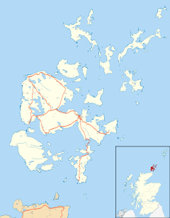
Orkney, also known as the Orkney Islands, is an archipelago in the Northern Isles off the north coast of Scotland. Orkney is 10 miles (16 km) north of Caithness and has about 70 islands, of which 20 are inhabited. The largest island, the Mainland, has an area of 523 square kilometres (202 sq mi), making it the sixth-largest Scottish island and the tenth-largest island in the British Isles. Orkney's largest settlement, and also its administrative centre, is Kirkwall.

Hoy is an island in Orkney, Scotland, measuring 143 square kilometres (55 sq mi) – the second largest in the archipelago, after Mainland. A natural causeway, the Ayre, links the island to the smaller South Walls; the two islands are treated as one entity by the UK census. Hoy is also the name of a hamlet in the northwest of the island.

The Mainland, also known as Hrossey and Pomona, is the main island of Orkney, Scotland. Both of Orkney's burghs, Kirkwall and Stromness, lie on the island, which is also the heart of Orkney's ferry and air connections.

Stronsay is an island in Orkney, Scotland. It is known as Orkney's 'Island of Bays', owing to an irregular shape with miles of coastline, with three large bays separated by two isthmuses: St Catherine's Bay to the west, the Bay of Holland to the south and Mill Bay to the east. Stronsay is 3,275 hectares in area, and 44 metres in altitude at its highest point. It has a usually resident population of 349. The main village is Whitehall, home to a heritage centre.
Westray is one of the Orkney Islands in Scotland, with a usual resident population of just under 600 people. Its main village is Pierowall, with a heritage centre, the 15th-century Lady Kirk church and pedestrian ferry service to nearby Papa Westray island. Westray has a number of archeological sites dating from 3500 BC, and remains of several Norse-Viking settlements. The spectacular sea cliffs around Noup Head are home to thousands of seabirds.

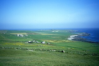
Shapinsay is one of the Orkney Islands off the north coast of mainland Scotland. With an area of 29.5 square kilometres (11.4 sq mi), it is the eighth largest island in the Orkney archipelago. It is low-lying and, with a bedrock formed from Old Red Sandstone overlain by boulder clay, fertile, causing most of the area to be used for farming. Shapinsay has two nature reserves and is notable for its bird life. Balfour Castle, built in the Scottish Baronial style, is one of the island's most prominent features, a reminder of the Balfour family's domination of Shapinsay during the 18th and 19th centuries; the Balfours transformed life on the island by introducing new agricultural techniques. Other landmarks include a standing stone, an Iron Age broch, a souterrain and a salt-water shower.

Wyre is one of the Orkney Islands, lying south-east of Rousay. It is 311 hectares (1.20 sq mi) and 32 metres (105 ft) at its highest point. It is one of the smallest inhabited islands in the archipelago.

North Ronaldsay is the northernmost island in the Orkney archipelago of Scotland. With an area of 690 hectares (2.7 sq mi), it is the fourteenth-largest. It is mentioned in the Orkneyinga saga; in modern times it is known for its historic lighthouse, migratory bird life and unusual breed of sheep.
Whitehall is the village on the island of Stronsay, in the Orkney Islands of Scotland. It is a small village with about 50 houses. It also has a shop, a café and heritage centre, known as the Fish Mart; the Stronsay Hotel, with attached pub; a post office, a fisherman's pier and a ferry pier.

Gairsay is a small island in Orkney, Scotland, located in the parish of Rendall, 1.5 miles (2.4 km) off the coast, astride one of the approaches to the bays of Firth and Kirkwall. It is about 2 miles (3.2 km) long and 1 mile (1.6 km) wide and includes one conical hill and a small harbour called Millburn Bay, which is sheltered by the peninsula known as the Hen of Gairsay.
Lochend is a mainly residential suburb of Edinburgh, the capital of Scotland. It is named after Lochend Castle and the adjacent Lochend Loch, located in the western part of Restalrig on the boundary between Leith and The Canongate, approximately two miles from Edinburgh city centre. The suburb consists largely of a 1930s public housing estate, and is bounded on the west by Easter Road.

Burroughston Broch is an Iron Age broch located on the island of Shapinsay in the Orkney Islands, in Scotland. The site overlooks the North Sea on the northeast part of Shapinsay. Excavated in the mid 19th century, Burroughston Broch is still well-preserved. The drystone walls are up to four metres thick in some parts and there is a complete chamber intact off the entrance passage. Some remains of stone fittings are evident in the interior.

Mill Dam is a wetland in western Shapinsay, in Orkney, Scotland.

Balfour Castle is a historic building on the southwest of Shapinsay, Orkney Islands. Though built around an older structure that dates at least from the 18th century, the present castle was built in 1847, commissioned by Colonel David Balfour, and designed by Edinburgh architect David Bryce. It is a Category A listed building and the landscape and formal gardens are listed in the Inventory of Gardens and Designed Landscapes in Scotland.

Mor Stein is a neolithic standing stone in the southeastern part of the island of Shapinsay, Orkney Islands, Scotland. Shapinsay is one of the two large inner islands of the Orkney group, and it is situated approximately two miles north of the Orkney Mainland. Linton Bay is situated slightly to the northeast of Mor Stein.

Symbister is the largest village and port on Whalsay, an island in the Shetland archipelago of Scotland. The population in 1991 was 797. The focus of the village is the harbour, which is home to small fishing boats as well as large deep sea trawlers. The village is overlooked by the granite mansion Symbister House, built by the Sixth Robert Bruce of Symbister in 1823. The harbour is also known by the names Bay Of Symbister, Symbister Harbour and Symbister Old Harbour.

Thieves Holm is a small island in Orkney, Scotland.
John Balfour was a Scottish politician and a civil servant in the East India Company with connections to the Orcadian island of Shapinsay.

Pierowall is a village of Westray in the Orkney Islands, off the coast of the northern Scottish mainland. The village is the island's largest settlement and lies near its northern end, around Pierowall Bay. It has a variety of historical remains dating from the Neolithic, the Iron Age, the Middle Ages, and later, including a large pagan Norse cemetery. In 1961 it had a population of 108.