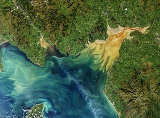
The Solway Firth is an inlet on the west coast of Great Britain, forming part of the border between England and Scotland. The "firth" divides Cumbria from Dumfries and Galloway. It stretches from St Bees Head, just south of Whitehaven in Cumbria, to the Mull of Galloway, on the western end of Dumfries and Galloway. The Isle of Man is also very near to the firth. The firth comprises part of the Irish Sea.

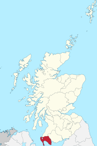
Dumfries and Galloway is one of the 32 unitary council areas of Scotland, located in the western part of the Southern Uplands. It is bordered by East Ayrshire, South Ayrshire, and South Lanarkshire to the north; Scottish Borders to the north-east; the English county of Cumbria, the Solway Firth, and the Irish Sea to the south, and the North Channel to the west. The administrative centre and largest settlement is the town of Dumfries. The second largest town is Stranraer, located 76 miles (122 km) to the west of Dumfries on the North Channel coast.

Kirkcudbright is a town, parish and a royal burgh from 1455 in Kirkcudbrightshire, of which it is traditionally the county town, within Dumfries and Galloway, Scotland.

Kirkcudbrightshire, or the County of Kirkcudbright or the Stewartry of Kirkcudbright is one of the historic counties of Scotland, covering an area in the south-west of the country. Until 1975, Kirkcudbrightshire was an administrative county used for local government. Since 1975, the area has formed part of Dumfries and Galloway for local government purposes. Kirkcudbrightshire continues to be used as a registration county for land registration. A lower-tier district called Stewartry covered the majority of the historic county from 1975 to 1996. The area of Stewartry district is still used as a lieutenancy area. Dumfries and Galloway Council also has a Stewartry area committee.

Wigtownshire or the County of Wigtown is one of the historic counties of Scotland, covering an area in the south-west of the country. Until 1975, Wigtownshire was an administrative county used for local government. Since 1975 the area has formed part of Dumfries and Galloway for local government purposes. Wigtownshire continues to be used as a territory for land registration, being a registration county. The historic county is all within the slightly larger Wigtown Area, which is one of the lieutenancy areas of Scotland and was used in local government as the Wigtown District from 1975 to 1996.

Dalbeattie (, Scots: Dawbeattie, Scottish Gaelic: Dail Bheithe meaning 'haugh of the birch', or Dail Bhàite 'drowned haugh' is a town in the historical county of Kirkcudbrightshire in Dumfries and Galloway, Scotland. Dalbeattie is in a wooded valley on the Urr Water 4 miles east of Castle Douglas and 12 miles south west of Dumfries. The town is famed for its granite industry and for being the home town of William McMaster Murdoch, the First Officer of the RMS Titanic.

Pladda is an uninhabited island 1 km (0.62 mi) off the south coast of the Isle of Arran in the Firth of Clyde at grid reference NS027191, western Scotland. It is home to the automated Pladda Lighthouse. The island is privately owned, having been put up for sale by Arran Estate in 1990. The island was put on sale in 2022 for £350,000, and bought shortly after.

Wood Island Light is an active lighthouse on the eastern edge of Wood Island in Saco Bay, on the southern coast of Maine. The light is just outside the entrance to Biddeford Pool and the end of the Saco River. The lighthouse is a 47-foot (14 m) conical white tower of granite rubble. The light itself sits 71 feet (22 m) above mean high water. Its automated beacon alternates between green and white every 10 seconds.

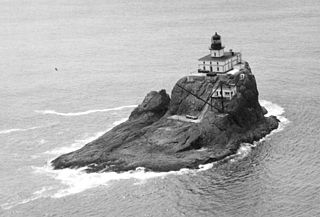
Tillamook Rock Light is a deactivated lighthouse on the northern Oregon Coast of the United States. It is located approximately 1.2 miles (1.9 km) offshore from Tillamook Head, and 20 miles (32 km) south of the mouth of the Columbia River near Astoria, situated on less than an acre of basalt rock in the Pacific Ocean. The construction of the lighthouse was commissioned in 1878 by the United States Congress and took more than 500 days to complete. Shortly before the completion of the lighthouse in January 1881, the barque Lupatia was wrecked near the rock during foggy weather and sank, with the loss of all 16 crew members.

The Stewartry Museum is a local museum in Kirkcudbright, Scotland, which covers the history of this part of Galloway.

The Islands of Fleet are a group of small islands in Galloway, Scotland. They are in Fleet Bay, which is part of Wigtown Bay, and is in turn part of the Solway Firth in the Irish Sea. There are three main islands.

Horse Island Light, also known as Sackets Harbor Light, is located on Horse Island in Sackets Harbor, Jefferson County in New York on Lake Ontario. In July 2017 the 24-acre island was acquired for preservation by the Civil War Trust, aided by a grant from the National Park Service. This was the first grant in the United States made for a War of 1812 site under the NPS battlefield grants program.

The Kincardine Lighthouse is a historic lighthouse located in Kincardine, Ontario, near the mouth of the Penetangore River. Built in 1881, it is 24.4 metres tall and was built above the light keeper's home. The tower is eight sided and sits on a stone foundation. The facility has been renovated and is now the Kincardine Yacht Club and a museum. It is open for tours from July 1 to Labour Day.
Events from the year 1960 in Scotland.
Kirkcudbright Academy is a state funded, six-year secondary school in Kirkcudbright, Scotland with about 400 pupils and 87 staff including teaching, support and administration.

The Cantick Head Lighthouse is an active 19th century lighthouse on the Scottish island of South Walls in the Orkney Islands. It is located at the end of Cantick Head, a long peninsula on the south-eastern coast of South Walls that overlooks the Pentland Firth and the Sound of Hoxa, which forms the southern entry to the natural harbour of Scapa Flow.

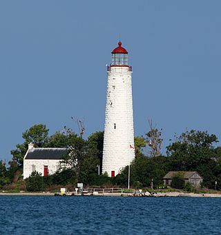
The Chantry Island Lighthouse, officially known as Chantry Island Lightstation Tower, is a lightstation on Chantry Island, off the coast of Southampton, Ontario in Lake Huron. It was constructed in the years 1855 through to 1859, by John Brown of Thorold, Ontario, under the authority of the Province of Canada and is recognized as one of the six Imperial Towers. Virtually identical, they were completed in 1858-1859 on Lake Huron and Georgian Bay and are among the few lighthouses on the Great Lakes made of cut limestone and granite.

The Ruvaal, Rhuvaal, or Rubh'a' Mhàil Lighthouse is a listed 19th-century lighthouse located at the north-eastern end of the island of Islay, in the Inner Hebrides off the west coast of Scotland. The active lighthouse marks the northern approaches to the Sound of Islay, a narrow channel separating Islay from the adjacent island of Jura, and is one of the seven lighthouses operated by the Northern Lighthouse Board, which act as maritime aids to navigation on and around Islay.

Kirkcudbright Bay is an inlet of the Irish Sea on the coast of Galloway in southwest Scotland. Its coastline falls entirely within the modern administrative area of Dumfries and Galloway and the historical county of Kirkcudbrightshire. It extends in a north-south direction for about 6 miles (10 km), and is up to 2 miles (3 km) wide.


