Firth is a word in the English and Scots languages used to denote various coastal waters in the United Kingdom, predominantly within Scotland. In the Northern Isles, it more often refers to a smaller inlet. It is linguistically cognate to fjord, which has a more constrained sense in English. Bodies of water named "firths" tend to be more common on the Scottish east coast, or in the southwest of the country, although the Firth of Clyde is an exception to this. The Highland coast contains numerous estuaries, straits, and inlets of a similar kind, but not called "firth" ; instead, these are often called sea lochs. Before about 1850, the spelling "Frith" was more common.

Dumfries and Galloway is one of 32 unitary council areas of Scotland and is located in the western Southern Uplands. It covers the historic counties of Dumfriesshire, Kirkcudbrightshire, and Wigtownshire, the latter two of which are collectively known as Galloway. The administrative centre and largest settlement is the town of Dumfries. The second largest town is Stranraer, on the North Channel coast, some 57 miles (92 km) to the west of Dumfries.

The Pentland Firth is a strait which separates the Orkney Islands from Caithness in the north of Scotland. Despite the name, it is not a firth.
Kirkcudbrightshire, or the County of Kirkcudbright or the Stewartry of Kirkcudbright is one of the historic counties of Scotland, covering an area in the south-west of the country. Until 1975, Kirkcudbrightshire was an administrative county used for local government. Since 1975, the area has formed part of Dumfries and Galloway for local government purposes. Kirkcudbrightshire continues to be used as a registration county for land registration. A lower-tier district called Stewartry covered the majority of the historic county from 1975 to 1996. The area of Stewartry district is still used as a lieutenancy area. Dumfries and Galloway Council also has a Stewartry area committee.

Swona is an uninhabited privately-owned island in the Pentland Firth off the north coast of Scotland.

A tidal island is a piece of land that is connected to the mainland by a natural or man-made causeway that is exposed at low tide and submerged at high tide. Because of the mystique surrounding tidal islands, many of them have been sites of religious worship, such as Mont-Saint-Michel with its Benedictine Abbey. Tidal islands are also commonly the sites of fortresses because of their natural fortifications.

Cramond Island is one of several islands in the Firth of Forth in eastern Scotland, near Edinburgh. It lies off the foreshore at Cramond. It is 1⁄3 mile (0.54 km) long and covers 19.03 acres (7.70 ha). The island is part of the Dalmeny Estate, owned by the Rosebery Estates Partnership, and is let to Cramond Boat Club.

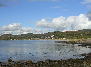
Kippford is a small village along the Solway coast, in the historic county of Kirkcudbrightshire in Dumfries and Galloway, Scotland. Also known as the Solway Riviera and has the most expensive property in Dumfries & Galloway.

Mudflat hiking is a recreation enjoyed in the Netherlands, northwest Germany, Denmark, England and France. Mudflat hikers are people who, with the aid of a tide table, use a period of low water to walk and wade on the watershed of the mudflats, especially from the Frisian mainland coast to the Frisian islands.
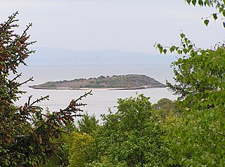
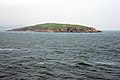
Rough Island is a 20-acre uninhabited tidal island located in the Rough Firth off the Solway Firth, Scotland, in the historical county of Kirkcudbrightshire, the same region where the River Urr flows into the Solway. The isle of Rough is 79 feet at its highest point.
@kingof_urmum

Urr Water or River Urr is a river in which flows through the counties of Dumfriesshire and Kirkcudbrightshire in southwest Scotland.

The Islands of the Forth are a group of small islands located in the Firth of Forth and in the estuary of the River Forth on the east coast of Scotland. Most of the group lie in the open waters of the firth, between the Lothians and Fife, with the majority to the east of the city of Edinburgh. Two islands lie further west in the river estuary.

Helliar Holm is an uninhabited island off the coast of Shapinsay in the Orkney Islands, Scotland. It is home to a 42-foot-tall (13 m) lighthouse, which was built in 1893 and automated in 1967. It is a tidal island that used to be connected to Shapinsay. It is still possible to walk across from the mainland during very low tides.

The Islands of Fleet are a group of small islands in Galloway, Scotland. They are in Fleet Bay, which is part of Wigtown Bay, and is in turn part of the Solway Firth in the Irish Sea. There are three main islands.
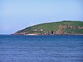
Rockcliffe is a small, coastal village in Kirkcudbrightshire, Dumfries and Galloway in Scotland, with a view of Rough Island, Hestan Island, the Solway Firth and sometimes the Cumbrian coast.
Rough Firth is an inlet on the northern coast of the Solway Firth in the Stewartry area of Dumfries and Galloway, Scotland. The firth lies between Almorness Point and Castlehill Point, and contains Rough Island. The village of Kippford stands near the head of the firth where the Urr Water reaches the sea; the only other coastal settlement of any size is Rockcliffe. The area is designated as the East Stewartry Coast National Scenic Area, one of the forty national scenic areas (NSAs) in Scotland.

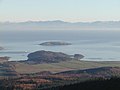
Orchardton Castle overlooks the Solway Coast. Built in the 1880s, this is a Grade B listed property formerly known as Orchardton House. Built around a Scottish Baronial-style mansion located in Auchencairn in the historical county of Kirkcudbrightshire in Dumfries and Galloway in Scotland. It overlooks the Solway Firth, with views to Cumbria and Hestan Island.


