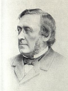
David Stevenson MICE FRSE FRSSA was a Scottish lighthouse designer, who designed over 30 lighthouses in and around Scotland, and helped continue the dynasty of lighthouse engineering founded by his father.

Cape Wrath is a cape in the Durness parish of the county of Sutherland in the Highlands of Scotland. It is the most north-westerly point in mainland Britain.
Auskerry is a small island in eastern Orkney, Scotland. It lies in the North Sea south of Stronsay and has a lighthouse, completed in 1866.
The Flannan Isles or alternatively, the Seven Hunters are a small island group in the Outer Hebrides of Scotland, approximately 32 kilometres (20 mi) west of the Isle of Lewis. They may take their name from Saint Flannan, the 7th century Irish preacher and abbot.

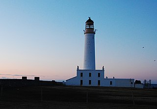
The Mull of Galloway is the southernmost point of Scotland. It is situated in Wigtownshire, Dumfries and Galloway, at the end of the Rhins of Galloway peninsula.

A bothy is a basic shelter, usually left unlocked and available for anyone to use free of charge. It was also a term for basic accommodation, usually for gardeners or other workers on an estate. Bothies are found in remote mountainous areas of Scotland, Northern England, Ulster and Wales. They are particularly common in the Scottish Highlands, but related buildings can be found around the world. A bothy was also a semi-legal drinking den in the Isle of Lewis. These, such as Bothan Eòrapaidh, were used until recent years as gathering points for local men and were often situated in an old hut or caravan.

Fidra is a currently uninhabited island in the Firth of Forth, 4 kilometres northwest of North Berwick, on the east coast of Scotland. The island is an RSPB Scotland nature reserve.

Sule Skerry is a remote skerry in the North Atlantic off the north coast of Scotland.

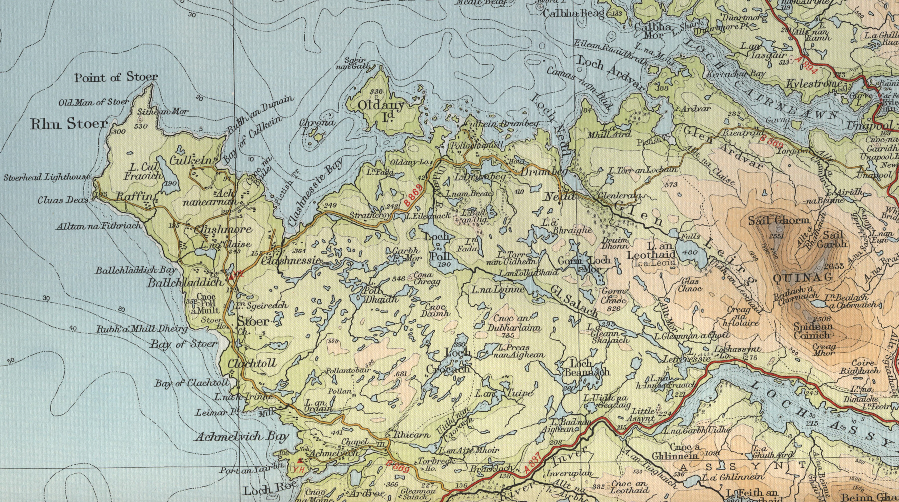
The Old Man of Stoer is a 60-metre-high (200 ft) sea stack of Torridonian sandstone in Sutherland, Scotland, close to villages of Culkein and Stoer and the nearby Stoer Head Lighthouse. It is a popular climbing route.
The Mountain Bothies Association (MBA) is a Scottish registered charity. It looks after 104 bothies and two emergency mountain shelters. Of these, only two bothies are owned by the charity. The remainder are maintained with the agreement and encouragement of the owners. The majority are in Scotland with the remainder in Wales and Northern England. These may be stayed in without charge.

Little Ross is a 29-acre (12-hectare) island with a lighthouse on the Solway Coast south of the town of Kirkcudbright in Galloway, Scotland. It is next to Meikle Ross on the mainland, which is a headland, and there are two small rocks off it, Sugarloaf and Fox Craig. The island can only be accessed by private boat or helicopter. Its sole electricity is supplied by solar panels and a small wind turbine.

Haskeir, also known as Great Haskeir is a remote, exposed and uninhabited island in the Outer Hebrides of Scotland. It lies 13 kilometres west-northwest of North Uist. 1 km southwest lie the skerries of Haskeir Eagach, made up of a colonnade of five rock stacks, and 40 km (25 mi) northwest is St Kilda.

The Montague Island Light is a heritage-listed active lighthouse located on Barunguba / Montague Island, an island in the Tasman Sea, 9 kilometres (5.6 mi) offshore from Narooma on the south coast of New South Wales, Australia. The lighthouse is located at the highest point of the island. It was designed by James Barnet and NSW Colonial Architect and built from 1878 to 1881 by J. Musson and completed By W. H. Jennings. It is also known as the Montague Island Lightstation and its setting. The property is owned by the Office of Environment and Heritage, an agency of the Government of New South Wales. It was added to the New South Wales State Heritage Register on 2 April 1999, and the Commonwealth Heritage List on 22 June 2004.

The Tiumpan Head Lighthouse is an active lighthouse located in Tiumpan Head, Isle of Lewis, Outer Hebrides, Scotland.

Flannan Isles Lighthouse is a lighthouse near the highest point on Eilean Mòr, one of the Flannan Isles in the Outer Hebrides off the west coast of mainland Scotland. It is best known for the mysterious disappearance of its keepers in 1900.

Rubha nan Gall lighthouse is located north of Tobermory on the Isle of Mull beside the Sound of Mull. The name means "Stranger's Point" in Scottish Gaelic. It was built in 1857 by David and Thomas Stevenson and is operated by the Northern Lighthouse Board. The lighthouse was automated in 1960 and the nearby former keepers' cottages are privately owned.

The Cantick Head Lighthouse is an active 19th century lighthouse on the Scottish island of South Walls in the Orkney Islands. It is located at the end of Cantick Head, a long peninsula on the south-eastern coast of South Walls that overlooks the Pentland Firth and the Sound of Hoxa, which forms the southern entry to the natural harbour of Scapa Flow.

The Noss Head Lighthouse is an active 19th-century lighthouse near Wick in Caithness in the Highland council area of Scotland. It is located at the end of Noss Head, a peninsula on the north-west coast of Caithness that overlooks Sinclairs Bay, three miles north-east of Wick. It is notable as being the first lighthouse that was built with a diagonally-paned lantern room.

The Ruvaal, Rhuvaal, or Rubh'a' Mhàil Lighthouse is a listed 19th century lighthouse, located at the north-eastern end of the island of Islay, in the Inner Hebrides off the west coast of Scotland. The active lighthouse marks the northern approaches to the Sound of Islay a narrow channel separating Islay from the adjacent island of Jura, and is one of the seven lighthouses operated by the Northern Lighthouse Board, which act as maritime aids to navigation on and around Islay.

Turnberry Lighthouse. or Turnberry Point Lighthouse, is a category B listed minor light on the South Ayrshire coast of Scotland. It was designed by David and Thomas Stevenson and completed in 1873. It is a conspicuous landmark from the Ayrshire Coastal Path and the Trump Turnberry golf resort.


