
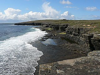
Stronsay is an island in Orkney, Scotland. It is known as Orkney's 'Island of Bays', owing to an irregular shape with miles of coastline, with three large bays separated by two isthmuses: St Catherine's Bay to the west, the Bay of Holland to the south and Mill Bay to the east. Stronsay is 3,275 hectares in area, and 44 metres in altitude at its highest point. It has a usually resident population of 349. The main village is Whitehall, home to a heritage centre.

Eday is one of the islands of Orkney, which are located to the north of the Scottish mainland. One of the North Isles, Eday is about 24 kilometres from the Orkney Mainland. With an area of 27 km2 (10 sq mi), it is the ninth-largest island of the archipelago. The bedrock of the island is Old Red Sandstone, which is exposed along the sea-cliffs.

Wyre is one of the Orkney Islands, lying south-east of Rousay. It is 311 hectares (1.20 sq mi) and 32 metres (105 ft) at its highest point. It is one of the smallest inhabited islands in the archipelago.
Papa Westray, also known as Papay, is one of the Orkney Islands in Scotland, United Kingdom. The fertile soil has long been a draw to the island.
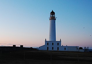
Auskerry is a small island in eastern Orkney, Scotland. It lies in the North Sea south of Stronsay and has a lighthouse, completed in 1866.

Papa Stronsay is a small island in Orkney, Scotland, lying north east of Stronsay. It is 74 hectares in size, and 13 metres (43 ft) above sea level at its highest point. After being largely abandoned, the island was bought at the end of the 20th century by traditionalist Catholic monks of the Sons of the Most Holy Redeemer, who operate a monastery and farm there.

The Congregation of the Sons of the Most Holy Redeemer, commonly known as the Transalpine Redemptorists or The Sons, are a religious institute of the Catholic Church canonically erected in the Roman Catholic Diocese of Aberdeen and based on Papa Stronsay in the Orkney Islands, Scotland, as well as in the city of Christchurch, New Zealand. They were formed in 1988 as a traditionalist offshoot of the Redemptorists, following a monastic rule based on that of Alphonsus Liguori, and was later formally erected as a religious institute in 2012.
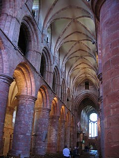
The Bishop of Orkney was the ecclesiastical head of the Diocese of Orkney, one of thirteen medieval bishoprics of Scotland. It included both Orkney and Shetland. It was based for almost all of its history at St Magnus Cathedral, Kirkwall.

Muckle Green Holm is an uninhabited island in the North Isles of the Orkney archipelago in Scotland. It is roughly 28 hectares (0.11 sq mi) in extent and rises to 28 metres (92 ft) above sea level, the summit having a trig point.

Helliar Holm is an uninhabited island off the coast of Shapinsay in the Orkney Islands, Scotland. It is home to a 42-foot-tall (13 m) lighthouse, which was built in 1893 and automated in 1967. It is a tidal island that used to be connected to Shapinsay. It is still possible to walk across from the mainland during very low tides.

The Holm of Faray is a small island in Orkney, Scotland, near Faray and Westray, which it lies between. Together with its neighbour Faray, it is designated a SSSI due to its importance as a haul-out site and breeding area for grey seals.

Rusk Holm is a small island in the Orkney Islands, near Faray to the west.

The Holm of Scockness is a small island in the Orkney Islands, between Rousay and Egilsay.

Linga Holm, commonly known as Linga, Midgarth and the Holm of Midgarth is an uninhabited Scottish island extending to approximately 57 hectares (0.22 sq mi) situated 700 metres (770 yd) west of Stronsay island in the Orkney archipelago. The name "Linga Holm" is derived from the Old Norse Lyngholm.
There are numerous islands containing the word holm, mainly in northern Europe. In many cases the name is derived from the Old Norse holmr, meaning "a small and rounded islet". These include:
Linga Sound may refer to:

Linga Sound is the strait between the islands of Linga Holm and Stronsay in the Orkney islands of Scotland. It leads into St. Catherines Bay from the north.

