
Orkney, also known as the Orkney Islands, is an archipelago in the Northern Isles of Scotland, situated off the north coast of the island of Great Britain. Orkney is 10 miles (16 km) north of the coast of Caithness and has about 70 islands, of which 20 are inhabited. The largest island, the Mainland, has an area of 523 square kilometres (202 sq mi), making it the sixth-largest Scottish island and the tenth-largest island in the British Isles. Orkney’s largest settlement, and also its administrative centre, is Kirkwall.
The Mainland, also known as Hrossey and Pomona, is the main island of Orkney, Scotland. Both of Orkney's burghs, Kirkwall and Stromness, lie on the island, which is also the heart of Orkney's ferry and air connections.

Stronsay is an island in Orkney, Scotland. It is known as Orkney's 'Island of Bays', owing to an irregular shape with miles of coastline, with three large bays separated by two isthmuses: St Catherine's Bay to the west, the Bay of Holland to the south and Mill Bay to the east. Stronsay is 3,275 hectares in area, and 44 metres in altitude at its highest point. It has a usually resident population of 349. The main village is Whitehall, home to a heritage centre.

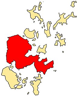
Shapinsay is one of the Orkney Islands off the north coast of mainland Scotland. There is one village on the island, Balfour, from which roll-on/roll-off car ferries sail to Kirkwall on the Orkney Mainland. Balfour Castle, built in the Scottish Baronial style, is one of the island's most prominent features, a reminder of the Balfour family's domination of Shapinsay during the 18th and 19th centuries; the Balfours transformed life on the island by introducing new agricultural techniques. Other landmarks include a standing stone, an Iron Age broch, a souterrain and a salt-water shower.

Wyre is one of the Orkney Islands, lying south-east of Rousay. It is 311 hectares (1.20 sq mi) and 32 metres (105 ft) at its highest point. It is one of the smallest inhabited islands in the archipelago.
Lamb Holm is a small uninhabited island in Orkney, Scotland. The Italian Chapel, constructed during the Second World War, is the island's main attraction.
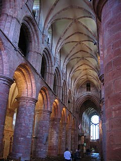
The Bishop of Orkney was the ecclesiastical head of the Diocese of Orkney, one of thirteen medieval bishoprics of Scotland. It included both Orkney and Shetland. It was based for almost all of its history at St Magnus Cathedral, Kirkwall.

Mill Dam is a wetland in western Shapinsay, in Orkney, Scotland.

Balfour Castle is a historic building on the southwest of Shapinsay, Orkney Islands. Though built around an older structure that dates at least from the 18th century, the present castle was built in 1847, commissioned by Colonel David Balfour, and designed by Edinburgh architect David Bryce. It is a Category A listed building and the landscape and formal gardens are listed in the Inventory of Gardens and Designed Landscapes in Scotland.

Mor Stein is a neolithic standing stone in the southeastern part of the island of Shapinsay, Orkney Islands, Scotland. Shapinsay is one of the two large inner islands of the Orkney group, and it is situated approximately two miles north of the Orkney Mainland. Linton Bay is situated slightly to the northeast of Mor Stein.

Helliar Holm is an uninhabited island off the coast of Shapinsay in the Orkney Islands, Scotland. It is home to a 42-foot-tall (13 m) lighthouse, which was built in 1893 and automated in 1967. It is a tidal island that used to be connected to Shapinsay. It is still possible to walk across from the mainland during very low tides.

The Bay of Linton is a bay on the east coast on the island of Shapinsay in the Orkney Islands, Scotland. To the north of Linton Bay are the headlands of Ness of Ork, and to the south is The Foot. The ancient monument the Broch of Burroughston is slightly north of Linton Bay.

Castle Bloody is a prehistoric feature on the island of Shapinsay, Orkney, Scotland. Hogan observes that while the feature is marked as a chambered mound on the UK Ordnance Survey map, the structure is more properly and specifically classified as a souterrain or earth house. Slightly to the north is located the ruined historic Linton Chapel.

Quholm is a hamlet in the northeast of Shapinsay, in the islands of Orkney, Scotland. William Irving, the father of Washington Irving, noted American author, was born in Quholm. Innsker Beach is situated very close by at the northwest edge of Quholm. Slightly to the south along Shapinsay's northwest coast are located the coastal ayres of Lairo Water and the Ouse situated within Veantro Bay. There are significant archaeological sites not distant from Quholm, including Odin's Stone, Burroughston Broch, Linton Chapel, Castle Bloody and Mor Stein.
There are numerous islands containing the word holm, mainly in northern Europe. In many cases the name is derived from the Old Norse holmr, meaning "a small and rounded islet". These include:

Holm of Grimbister is an inhabited tidal islet in the Orkney archipelago of Scotland. Located in the Bay of Firth near Finstown it is connected to Mainland Orkney by a causeway.

