River Forth (Tasmania)

Last updated

River Forth at Forth. Forth-River-Tasmania-20070420-002.jpg
River Forth at Forth.

The River Forth is a perennial river located in northwest Tasmania, Australia. [1]

Contents

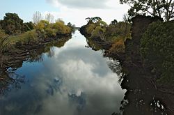
Location and features

The lower part of the river features Lake Barrington, which is a major venue for competitive rowing. It is also the location of the village of Forth.

The river is a part of the Mersey-Forth power project, which includes seven hydroelectric power stations. Three hydroelectric power stations have been built on the Forth River itself, including Cethana Power Station (impounding Lake Cethana); Devils Gate Power Station (impounding Lake Barrington); and Paloona Power Station (impounding Lake Paloona.)

The upper part of the river catchment area is also known as the Forth River High Country and contains the Cradle Mountain-Lake St Clair National Park [2] with the source of the river being on the southern slopes of Mount Pelion West.

The catchment for the river is 1,126 square kilometres (435 sq mi). [3]

See also

Related Research Articles

<span class="mw-page-title-main">Lake Pedder</span> Lake in South West Tasmania, Australia

Lake Pedder, once a glacial outwash lake, is a man-made impoundment and diversion lake located in the southwest of Tasmania, Australia. In addition to its natural catchment from the Frankland Range, the lake is formed by the 1972 damming of the Serpentine and Huon rivers by the Hydro Electric Commission of Tasmania for the purposes of hydroelectric power generation.

<span class="mw-page-title-main">Mersey River (Tasmania)</span> River in Tasmania, Australia

The Mersey River is a river on the north-west coast of Tasmania, Australia. The city of Devonport is situated at the river's mouth on Bass Strait.

<span class="mw-page-title-main">Pieman River</span> River in western Tasmania, Australia

The Pieman River is a major perennial river located in the west coast region of Tasmania, Australia.

The Tribute Power Station is a conventional hydroelectric power station located in Western Tasmania, Australia.

The Cethana Power Station is a conventional hydroelectric power station located in north-western Tasmania, Australia.

The Rowallan Power Station is a conventional hydroelectric power station located in north-western Tasmania, Australia. The station is located 25 kilometres (16 mi) south of Liena.

The Fisher Power Station is a conventional hydroelectric power station located in north-western Tasmania, Australia.

The Lemonthyme Power Station is a conventional hydroelectric power station located in north-western Tasmania, Australia. It is the third station in the Mersey–Forth run-of-river scheme that comprises seven conventional hydroelectric power stations and one mini hydro station.

<span class="mw-page-title-main">Devils Gate Power Station</span> Dam in North-western Tasmania

The Devils Gate Power Station is a conventional hydroelectric power station located in north-western Tasmania, Australia. The dam is 84 metres (276 ft) high. It is one of the thinnest concrete arch dams in the world.

<span class="mw-page-title-main">Paloona Power Station</span> Dam in Northern Tasmania

The Paloona Power Station is a conventional hydroelectric power station located in northern Tasmania, Australia.

The Wilmot Power Station is a conventional hydroelectric power station located in north-western Tasmania, Australia.

The Murchison River, part of the Pieman River catchment, is a major perennial river located in the West Coast region of Tasmania, Australia.

The Mackintosh River, part of the Pieman River catchment, is a major perennial river located in the West Coast region of Tasmania, Australia. The river was named in November 1828 by Henry Hellyer, a surveyor of the Van Diemans Land Company, in honour of Sir James Mackintosh, son of John Mackintosh of Kyllachy, Inverness-shire

Lake Mackintosh is a 17.5-kilometre-long (10.9 mi) reservoir with a surface area of 3,100-hectare (7,700-acre) that forms part of the Pieman power development running north–south past Mount Farrell, adjacent to the town of Tullah in Tasmania.

The Scotts Peak Dam is a rockfill embankment dam without a spillway across the Huon River, located in the South West region of Tasmania, Australia.

The Serpentine Dam is a rockfill embankment dam with a concrete face and a controlled spillway across the Serpentine River, located in the South West region of Tasmania, Australia.

The Anthony Power Development Scheme, part of the Pieman River power development scheme, was a proposed scheme for damming parts of the upper catchment of the Pieman River in Western Tasmania, Australia.

Moina is a town 45 km inland from Devonport on the north-west coast of Tasmania, Australia. Moina was the site of a brief gold rush in the late nineteenth century and then one of the largest wolfram and bismuth mines in Tasmania. It has been the centre of continued mineral exploration in the Middlesex district since the first discoveries of tin and tungsten ores on Dolcoath Hill in the 1890s. The name may be a derivation of a small crustacean of the same name found in Tasmanian waters.

Paloona is a rural locality in the local government areas of Devonport and Kentish in the North-west and west region of Tasmania. The locality is about 16 kilometres (9.9 mi) south-west of the town of Devonport. The 2016 census has a population of 64 for the state suburb of Paloona.

References

  1. "Supporting more efficient irrigation in Tasmania". 4 July 2022. Retrieved 9 October 2022.
  2. Haygarth, Nick (1998) A View to Cradle: A History of Tasmania's Forth River High Country ISBN   0-646-34293-2
  3. http://www.environment.gov.au/ssd/publications/ssr/pubs/ssr167.pdf [ bare URL PDF ]

41°37′S146°08′E / 41.61°S 146.13°E / -41.61; 146.13 Coordinates: 41°37′S146°08′E / 41.61°S 146.13°E / -41.61; 146.13