
The River Derwent is a river located in Tasmania, Australia. It is also known by the palawa kani name timtumili minanya. The river rises in the state's Central Highlands at Lake St Clair, and descends more than 700 metres (2,300 ft) over a distance of more than 200 kilometres (120 mi), flowing through Hobart, the state's capital city, before emptying into Storm Bay and flowing into the Tasman Sea. The banks of the Derwent were once covered by forests and occupied by Aboriginal Tasmanians. European settlers farmed the area and during the 20th century many dams were built on its tributaries for the generation of hydro-electricity.

Lake St Clair or leeawulenna is a natural freshwater lake located in the Central Highlands area of Tasmania, Australia. The lake forms the southern end of the Cradle Mountain-Lake St Clair National Park. It has an area of approximately 45 square kilometres (17 sq mi), and a maximum depth of 160 metres (520 ft), making it Australia's deepest lake.

The Tasmanian giant freshwater crayfish, also called Tasmanian giant freshwater lobster, is the largest freshwater invertebrate and the largest freshwater crayfish species in the world. The species is only found in the rivers below 400 metres (1,300 ft) above sea level in northern Tasmania, an island-state of Australia. It is listed as an endangered species on the IUCN Red List due to overfishing and habitat degradation, and it has been prohibited to catch the crayfish since 1998.

The Huon River is a perennial river located in the south-west and south-east regions of Tasmania, Australia. At 174 kilometres (108 mi) in length, the Huon River is the fifth-longest in the state, with its course flowing east through the fertile Huon Valley and emptying into the D'Entrecasteaux Channel, before flowing into the Tasman Sea.

The Barron River is located on the Atherton Tablelands inland from Cairns in northern Queensland, Australia. With its headwaters below Mount Hypipamee, the 165-kilometre (103 mi)-long river with a catchment area of approximately 2,138 square kilometres (825 sq mi) forms through run off from the Mount Hypipamee National Park, flows through Lake Tinaroo, and eventually empties into the Coral Sea near Smithfield.
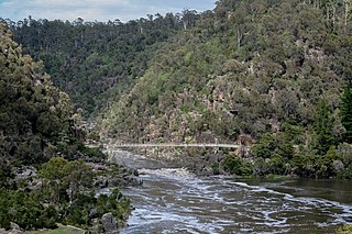
The South Esk River, the longest river in Tasmania, is a major perennial river located in the northern region of Tasmania, Australia.

Lilydale, originally known as Upper Piper, is a small town in northern Tasmania, Australia. The town is 28 kilometres (17 mi) northeast of Launceston and is a part of the Launceston municipality, except for about 4% which is in the Dorset LGA. It is located near Mount Arthur. At the 2006 census, Lilydale had a population of 288. The town's notable attractions include the Lilydale Falls, two small waterfalls, Mount Arthur, and, along the main street, a series of telegraph poles painted with murals.
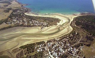
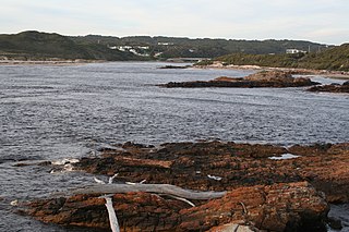
Bellingham is a rural locality in the local government area (LGA) of George Town in the Launceston LGA region of Tasmania. The locality is about 39 kilometres (24 mi) north-east of the town of George Town. The 2016 census has a population of 60 for the state suburb of Bellingham. It is a tiny coastal hamlet in northern Tasmania, situated on the mouth of the Pipers River directly opposite the town of Weymouth. The town is located 62 kilometres (39 mi) from Launceston, 20 kilometres (12 mi) from Bridport and 38 kilometres (24 mi) from George Town.
Weymouth is a rural locality in the local government area (LGA) of George Town in the Launceston LGA region of Tasmania. The locality is about 37 kilometres (23 mi) north-east of the town of George Town. The 2016 census has a population of 129 for the state suburb of Weymouth. It is a small township in northern Tasmania, on the Pipers River opposite Bellingham and about 60 km from Launceston. It has a very small permanent population; however, it attracts many visitors during the summer months. Weymouth has a beach, a tennis court, and a community hall with a playground.

Underwood is a rural locality and town in the local government area of Launceston, in the Northern region of Tasmania. It is located about 22 kilometres (14 mi) north-east of the city of Launceston. The 2016 census determined a population of 363 for the state suburb of Underwood.

Launceston City Council is a local government body in Tasmania, located in the city and surrounds of Launceston in the north of the state. The Launceston local government area is classified as urban and has a population of 67,449, which also encompasses the localities including Lilydale, Targa and through to Swan Bay on the eastern side of the Tamar River.

The Macquarie River is a major perennial river located in the Midlands region of Tasmania, Australia.
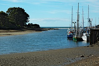
The Inglis River is a river in North West Tasmania, Australia, it extends approximately 61 kilometres (38 mi) from the Campbell Ranges near Takone before discharging into Bass Strait at Wynyard. The Flowerdale River is the largest tributary system on the Inglis River and makes up approximately one-third of the 471-square-kilometre (182 sq mi) Inglis-Flowerdale catchment basin.
The Archer River is a river located on the Cape York Peninsula, Far North Queensland, Australia.
The Arthur River is a major perennial river located in the north-west region of Tasmania, Australia.
The Lune River is a perennial river located in south-eastern Tasmania, Australia.
The Flowerdale River is a river in North West Tasmania, Australia, it extends approximately 55 kilometres (34 mi) from the Campbell Ranges near West Takone before discharging into the Inglis River at Wynyard. The Flowerdale is the largest tributary system on the Inglis River and makes up approximately one-third of the 471-square-kilometre (182 sq mi) Inglis-Flowerdale catchment basin.

Table Cape is a volcanic plug located near Wynyard on the North West of Tasmania, Australia, it is also the name of the locality which encompasses the geological feature. Table Cape is a more or less circular volcanic plug with a flat top, its northern and eastern faces rise steeply from Bass Strait to a height of approximately 170 metres (560 ft) above sea level. It was named by British navigator, Matthew Flinders, as he and George Bass circumnavigated Van Diemen's Land in 1798 upon the Norfolk. Flinders also progressively named the nearby Circular Head, Three Hummock and Hunter Islands.
Karoola is a rural locality and town in the local government area of Launceston, in the Northern region of Tasmania. It is located about 26 kilometres (16 mi) north of the city of Launceston. The 2016 census determined a population of 318 for the state suburb of Karoola.
Pipers Brook is a rural locality in the local government areas of Launceston, Dorset and George Town in the Launceston and North-east regions of Tasmania. It is located about 33 kilometres (21 mi) east of the town of George Town. The 2016 census determined a population of 93 for the state suburb of Pipers Brook.

