Related Research Articles

The freckled duck is a waterfowl species endemic to Australia. The freckled duck has also been referred to as the monkey duck or oatmeal duck. These birds are usually present in mainland Australia, but disperse to coastal and subcostal wetlands in the dry period. During such times it is common for the freckled duck population to congregate in flocks in the same area, giving the impression that they are more common than they really are.

The Murrumbidgee River is a major tributary of the Murray River within the Murray–Darling basin and the second longest river in Australia. It flows through the Australian state of New South Wales and the Australian Capital Territory, descending 1,500 metres (4,900 ft) over 1,485 kilometres (923 mi), generally in a west-northwesterly direction from the foot of Peppercorn Hill in the Fiery Range of the Snowy Mountains towards its confluence with the Murray River near Boundary Bend.

The Snowy River is a major river in south-eastern Australia. It originates on the slopes of Mount Kosciuszko, Australia's highest mainland peak, draining the eastern slopes of the Snowy Mountains in New South Wales, before flowing through the Alpine National Park and the Snowy River National Park in Victoria and emptying into Bass Strait.

The Rangitaiki River is the longest river in the Bay of Plenty region in New Zealand's North Island. It is 155 kilometres (96 mi) long, and rises inland from northern Hawkes Bay to the east of the Kaingaroa Forest. The Rangitaiki catchment covers an area of 3005 km2. It flows in a generally northeastward direction, passing through the town of Murupara and skirting close to the western edge of Te Urewera National Park before turning northwards, flowing past Edgecumbe and into the Bay of Plenty close to Thornton.

The Elbow River is a river in southern Alberta, Canada. It flows from the Canadian Rockies to the city of Calgary, where it merges into the Bow River.

The Albert River is a perennial river located in the South East region of Queensland, Australia. Its catchment lies within the Gold Coast and Scenic Rim Region local government areas and covers an area of 782 square kilometres (302 sq mi). The river provides potable water for the town of Beaudesert.

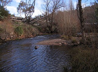
The Duck River is a perennial stream and southern tributary of the Parramatta River, in Sydney, New South Wales, Australia.
A'Becketts Creek is a perennial stream and a northern tributary of the Duck River and part of the Parramatta River catchment, in Sydney, New South Wales, Australia.

Duck Creek is a perennial stream and a southern tributary of A'Becketts Creek and part of the Parramatta River catchment, in Sydney, New South Wales, Australia.
The Yalgar River is a 185-kilometre-long tributary of the Murchison River, located in the Shire of Meekatharra in central Western Australia. It rises in the Glengarry Range 25 km southeast of Mooloogool Station homestead, about 80 kilometres northeast of Meekatharra, flowing 145 kilometres westward to a junction with the Hope River. From there it flows north-northwesterly for about 40 kilometres, emptying into the upper reaches of the Murchison River, near Moorarie Station homestead on the Carnarvon-Meekatharra Road.

The Fraser Pass is a mountain pass in the British Columbian Rockies of Western Canada. Its summit is 2,015 m (6,611 ft) above sea level. Although immediately adjacent to the Continental Divide, the pass does not cross it; rather, it bridges the drainage basins of the Fraser River and Columbia River, both Pacific-draining rivers.
The Cobungra River, a perennial river of the North-East Murray catchment of the Murray-Darling basin, is located in the East Gippsland and alpine regions of Victoria, Australia.

The Big River, a perennial river of the North-East Murray catchment of the Murray-Darling basin, is located in the East Gippsland and alpine regions of Victoria, Australia. It flows from the northern slopes of Falls Creek in the Australian Alps, joining with the Cobungra River near Anglers Rest to form the Mitta Mitta River.
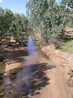
The Alice River in central Queensland, Australia rises on the western slopes of the Great Dividing Range. The river bisects the Shire of Barcaldine, flowing in a south-westerly direction towards Isisford and its confluence with the Barcoo River. The town of Barcaldine is located on the Alice River. The Alice River's tributaries include Jordan Creek and Lagoon Creek. The Alice River is often dry, except after the annual summer rains.
The Lunenburgh River is a perennial river in the South West region of Western Australia.

Stroubles Creek is an approximately 12-mile-long (19 km) stream that runs through the town of Blacksburg, the Virginia Tech campus, and Montgomery County, Virginia until it empties into the New River. Most of the sections of Stroubles Creek that flow through Blacksburg and the Virginia Tech campus are piped underground, while the portion that flows through Montgomery County is above-ground. Stroubles Creek has been designated an impaired waterway since 2002.
Hoddles Creek is a creek near Melbourne in Victoria, Australia.

The Roaring River is a right tributary of the Swan River in Manitoba, Canada.
Wy Yung is a town in Victoria, Australia, located on Great Alpine Road, in the Shire of East Gippsland near Bairnsdale. The town's name means wild duck in the local indigenous language.
References
- ↑ "State of Rivers Report for the Duck River Catchment" (PDF). 2003. Retrieved 29 December 2016.