The River Derwent is a river located in Tasmania, Australia. It is also known by the palawa kani name timtumili minanya. The river rises in the state's Central Highlands at Lake St Clair, and descends more than 700 metres (2,300 ft) over a distance of more than 200 kilometres (120 mi), flowing through Hobart, the state's capital city, before emptying into Storm Bay and flowing into the Tasman Sea. The banks of the Derwent were once covered by forests and occupied by Aboriginal Tasmanians. European settlers farmed the area and during the 20th century many dams were built on its tributaries for the generation of hydro-electricity.
Lake Margaret is a concrete-faced gravity dam with an uncontrolled spillway across the Yolande River, located on the north side of Mount Sedgwick, in the West Coast Range, West Coast of Tasmania, Australia.

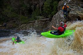
The Huon River is a perennial river located in the south-west and south-east regions of Tasmania, Australia. At 174 kilometres (108 mi) in length, the Huon River is the fifth-longest in the state, with its course flowing east through the fertile Huon Valley and emptying into the D'Entrecasteaux Channel, before flowing into the Tasman Sea.
The Crotty Dam, also known during construction as the King Dam, or the King River Dam on initial approval, is a rockfill embankment dam with a controlled and uncontrolled spillway across the King River, between Mount Jukes and Mount Huxley, located in Western Tasmania, Australia.
The Catagunya Power Station is a run-of-the-river hydroelectric power station located in the Central Highlands region of Tasmania, Australia. The power station is situated on the Lower River Derwent catchment and is owned and operated by Hydro Tasmania.
The Lake Echo Power Station is a conventional hydroelectric power station located in the Central Highlands region of Tasmania, Australia. The power station is situated on the Upper River Derwent catchment and is owned and operated by Hydro Tasmania.
The Fisher Power Station is a conventional hydroelectric power station located in north-western Tasmania, Australia.

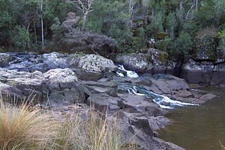
The Clyde River, also known as the River Clyde, part of the River Derwent catchment, is a perennial river located in the Midlands region of Tasmania, Australia.

Mount Pelion West is a mountain located in the Central Highlands region of Tasmania, Australia. The mountain is part of the Pelion Range and is situated within the Cradle Mountain-Lake St Clair National Park at the easternmost boundary of the Murchison River catchment.

The Gordon Dam, also known as the Gordon River Dam, is a major gated double curvature concrete arch dam with a controlled spillway across the Gordon River, located in South West Tasmania, Australia. The impounded reservoir is called Lake Gordon.
The Scotts Peak Dam is a rockfill embankment dam without a spillway across the Huon River, located in the South West region of Tasmania, Australia.
The Serpentine Dam is a rockfill embankment dam with a concrete face and a controlled spillway across the Serpentine River, located in the South West region of Tasmania, Australia.
The Edgar Dam is an earthfill embankment saddle dam without a spillway, located offstream in the South West region of Tasmania, Australia.
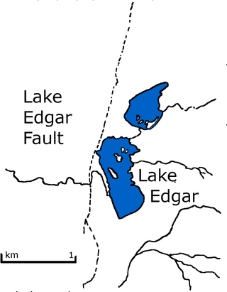
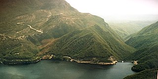
Lake Edgar was a natural fault scarp pond on the upper reaches of the Huon River in South West Tasmania.
The Weld Valley is a valley located in southern Tasmania. It is an area of aboriginal cultural heritage and natural history within the Tasmanian Wilderness World Heritage Area. The valley stretches north-west of Huonville and is approximately 50 kilometres (31 mi) west of Hobart.
The Anne River is a perennial river located in the south-west region of Tasmania, Australia. At 20 kilometres (12 mi) in length, the Anne River is extremely steep and flows through parts of the Tasmanian Wilderness World Heritage Area.
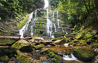
The Nelson Falls, a cascade waterfall, is located in the UNESCO World Heritage–listed Tasmanian Wilderness, in the West Coast region of Tasmania, Australia.
The Meander Dam is a concrete gravity dam across the Upper Meander River, located in northern Tasmania, Australia. The impounded reservoir is called Lake Huntsman.
The Boyd River, part of the Gordon River catchment, is a perennial river located in the south western region of Tasmania, Australia.
The Supply River is a perennial river located in the northern region of Tasmania, Australia.