
The Franklin River is a major perennial river located in the Central Highlands and western regions of Tasmania, Australia. The river is located in the Franklin-Gordon Wild Rivers National Park at the mid northern area of the Tasmanian Wilderness World Heritage Area. Its source is situated at the western edge of the Central Highlands and it flows west towards the West Coast.

Lake Pedder, once a glacial outwash lake, is a man-made impoundment and diversion lake located in the southwest of Tasmania, Australia. In addition to its natural catchment from the Frankland Range, the lake is formed by the 1972 damming of the Serpentine and Huon rivers by the Hydro Electric Commission of Tasmania for the purposes of hydroelectric power generation.

The Franklin Dam or Gordon-below-Franklin Dam project was a proposed dam on the Gordon River in Tasmania, Australia, that was never constructed. The movement that eventually led to the project's cancellation became one of the most significant environmental campaigns in Australian history.

Lake Gordon is a man-made reservoir created by the Gordon Dam, located on the upper reaches of the Gordon River in the south-west region of Tasmania, Australia.

The Gordon River is a major perennial river located in the central highlands, south-west, and western regions of Tasmania, Australia.
Hydro Tasmania, known for most of its history as the Hydro-Electric Commission (HEC) or The Hydro, is the trading name of the Hydro-Electric Corporation, a Tasmanian Government business enterprise which is the predominant electricity generator in the state of Tasmania, Australia. The Hydro was originally oriented towards hydro-electricity, due to Tasmania's dramatic topography and relatively high rainfall in the central and western parts of the state. Today Hydro Tasmania operates thirty hydro-electric and one gas power station, and is a joint owner in three wind farms.

The Great Lake is a natural lake and man-made reservoir that is located in the central northern region of Tasmania, Australia.
Olegas Truchanas was a Lithuanian-Australian conservationist and nature photographer.

The Gordon Power Station is the largest conventional hydroelectric power station in Tasmania, Australia; located in the South West region of the state. The power station is situated on Gordon River. Water from Lake Gordon descends 183 metres (600 ft) underground past the Gordon Dam and into the power station.
South West Tasmania is a region in Tasmania that has evoked curiosity as to its resources over the duration of European presence on the island.
The Gordon River Road, sometimes called the Strathgordon Road, (B61), is a road in the south western region of Tasmania, Australia.
The Gordon Dam, also known as the Gordon River Dam, is a major gated double curvature concrete arch dam with a controlled spillway across the Gordon River, located in South West Tasmania, Australia. The impounded reservoir is called Lake Gordon.
The Scotts Peak Dam Road is the most southerly point of road access into the south western region of Tasmania, Australia.
The Scotts Peak Dam is a rockfill embankment dam without a spillway across the Huon River, located in the South West region of Tasmania, Australia.
The Serpentine Dam is a rockfill embankment dam with a concrete face and a controlled spillway across the Serpentine River, located in the South West region of Tasmania, Australia.
The Edgar Dam is an earthfill embankment saddle dam without a spillway, located offstream in the South West region of Tasmania, Australia.
The Anthony Power Development Scheme, part of the Pieman River power development scheme, was a proposed scheme for damming parts of the upper catchment of the Pieman River in Western Tasmania, Australia.

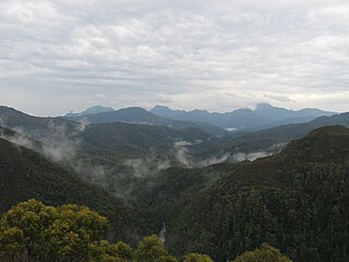
The Frankland Range is a mountain range that is located in the south-west region of Tasmania, Australia. The range forms part of a natural south-western border to the impounded Lake Pedder, formed by the damming of the Serpentine and Huon rivers.
The Lake Pedder Action Committee was a Tasmanian environmental group.
This page discusses the rivers and hydrography of the state of Tasmania, Australia.
