Rosebery Tasmania | |||||||||
---|---|---|---|---|---|---|---|---|---|
Coordinates | 41°46′45″S145°32′25″E / 41.77917°S 145.54028°E Coordinates: 41°46′45″S145°32′25″E / 41.77917°S 145.54028°E | ||||||||
Population | 752 (SAL 2021) [1] | ||||||||
Postcode(s) | 7470 | ||||||||
Elevation | 165 m (541 ft) [2] | ||||||||
Location |
| ||||||||
LGA(s) | West Coast Council | ||||||||
State electorate(s) | House of Assembly: Braddon Legislative Council Division: Murchison | ||||||||
Federal division(s) | Braddon | ||||||||
|
Rosebery is a town on the west coast of Tasmania, Australia. It is at the northern end of the West Coast Range, in the shadow of Mount Black and adjacent to the Pieman River now Lake Pieman.
It lies on the Murchison Highway, 25 kilometres north-east of Zeehan and is part of the Municipality of West Coast Council. At the 2021 census, Rosebery had a population of 752. [3]
The population of Rosebery declined by 22% in the years between 1996-2001. [4] Its newer western area on the shore of Lake Pieman is known as Primrose.
Like most of the other settlements on the west coast of Tasmania, Rosebery is a mining town. In 1893, prospector Tom McDonald discovered gold in alluvial wash, along with boulders of zinc-lead sulphide in dense rainforest on the slopes of Mount Black. McDonald pegged several claims in the name of the Rosebery Prospecting Association (named after Lord Rosebery [5] ), which later became the Rosebery Gold Mining Company. The South Rosebery Mining Company was formed soon after to mine the southern continuation of the orebody.
In 1896, the Rosebery Gold Mining Company was reconstructed as the Tasmanian Copper Company, and the South Rosebery Mining Company became the Primrose Mining Company. Rosebery Post Office opened on 1 November 1897. [6]
The main mineral found in the orebody was zinc, but due to the lack of a technique to successfully extract the zinc from the ore, little could be done to exploit the orebody. One company formed to experiment in the processing of zinc ores was the Tasmanian Metals Extraction Company (TME) who built a large plant next to the track to Williamsford, completed in 1912. The experiment was unsuccessful and the plant closed in 1914.
The Rosebery mines passed into the hands of the Mount Lyell Mining and Railway company in 1916, and the mines were eventually merged with the Electrolytic Zinc Company of Australasia (EZ), who had discovered an effective method for the extraction of zinc. In 1926, construction of a processing mill at Rosebery began, and in 1931, an aerial ropeway to transport ore from the Hercules Mine near Williamsford was completed. Due to the Great Depression, the Rosebery Mill was not completed until 1936. The Rosebery Mine has operated continuously since then, with 75 year celebrations held during February, 2011. The mine is currently operated by Minerals and Metals Group (MMG), producing zinc, lead, copper, silver and gold. [7] Previous mine owners included Pasminco and Zinifex.
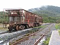
Prior to the construction of the Murchison Highway in the 1960s, the town was connected with Burnie and North West Tasmania via the Emu Bay Railway.
Climate data for Rosebery (HEC Substation) (165 m AMSL) 1979-1993 | |||||||||||||
---|---|---|---|---|---|---|---|---|---|---|---|---|---|
Month | Jan | Feb | Mar | Apr | May | Jun | Jul | Aug | Sep | Oct | Nov | Dec | Year |
Record high °C (°F) | 38.0 (100.4) | 36.8 (98.2) | 31.5 (88.7) | 28.0 (82.4) | 24.5 (76.1) | 17.7 (63.9) | 16.1 (61.0) | 19.1 (66.4) | 22.5 (72.5) | 27.6 (81.7) | 32.0 (89.6) | 35.6 (96.1) | 38.0 (100.4) |
Average high °C (°F) | 21.0 (69.8) | 21.9 (71.4) | 20.1 (68.2) | 17.0 (62.6) | 14.1 (57.4) | 11.3 (52.3) | 11.0 (51.8) | 12.1 (53.8) | 13.3 (55.9) | 16.4 (61.5) | 18.6 (65.5) | 20.5 (68.9) | 16.4 (61.5) |
Average low °C (°F) | 10.1 (50.2) | 9.7 (49.5) | 9.2 (48.6) | 7.7 (45.9) | 6.2 (43.2) | 4.3 (39.7) | 3.5 (38.3) | 4.3 (39.7) | 5.0 (41.0) | 6.4 (43.5) | 7.7 (45.9) | 9.6 (49.3) | 7.0 (44.6) |
Record low °C (°F) | 3.5 (38.3) | 1.8 (35.2) | 2.5 (36.5) | 0.5 (32.9) | 0.0 (32.0) | −3.0 (26.6) | −3.0 (26.6) | −2.5 (27.5) | −1.5 (29.3) | −1.0 (30.2) | −0.5 (31.1) | 2.8 (37.0) | −3.0 (26.6) |
Average rainfall mm (inches) | 129.5 (5.10) | 81.6 (3.21) | 102.8 (4.05) | 150.7 (5.93) | 172.7 (6.80) | 199.9 (7.87) | 208.7 (8.22) | 211.1 (8.31) | 233.2 (9.18) | 189.7 (7.47) | 147.0 (5.79) | 134.5 (5.30) | 1,961.4 (77.23) |
Average rainy days (≥ 1mm) | 13.8 | 9.5 | 12.0 | 14.1 | 15.9 | 17.7 | 18.7 | 20.7 | 20.2 | 18.3 | 13.7 | 13.6 | 188.2 |
Source: Bureau of Meteorology [2] |
Zeehan is a town on the west coast of Tasmania, Australia 139 kilometres (86 mi) south-west of Burnie. It is part of the West Coast Council, along with the seaport Strahan, and neighbouring mining towns of Dundas, Rosebery and Queenstown.
The West Coast Range is a mountain range located in the West Coast region of Tasmania, Australia.
The West Coast of Tasmania is mainly isolated rough country, associated with wilderness, mining and tourism. It served as the location of an early convict settlement in the early history of Van Diemen's Land, and contrasts sharply with the more developed and populous northern and eastern parts of the island state.
Mount Lyell Mining and Railway Company was a Tasmanian mining company formed on 29 March 1893, most commonly referred to as Mount Lyell. Mount Lyell was the dominant copper mining company of the West Coast from 1893 to 1994, and was based in Queenstown, Tasmania.
The Melba Line is a 1,067 mm narrow-gauge railway on the West Coast of Tasmania. The line was originally constructed as a private railway line named the Emu Bay Railway and was one of the longest-lasting and most successful private railway companies in Australia. While at present the line travels from Burnie to Melba Flats, it previously ran through to Zeehan carrying minerals and passengers as an essential service for the West Coast community.
The North East Dundas Tramway was a 2 ft narrow gauge tramway, that ran between Zeehan and Deep Lead on the West Coast of Tasmania. Opening in 1896 and closing in 1932, it was part of the Tasmanian Government Railways network. The world's first Garratt locomotives, the K class, were used on the line.
Mount Read is a mountain located in the West Coast region of Tasmania, Australia, and is at the north west edge of the West Coast Range.
The Mount Jukes Mine sites were a series of short-lived, small mine workings high on the upper regions of Mount Jukes in the West Coast Range on the West Coast of Tasmania.
The mines of the West Coast of Tasmania have a rich historical heritage as well as an important mineralogical value in containing or having had found, specimens of rare and unusual minerals. Also, the various mining fields have important roles in the understanding of the mineralization of the Mount Read Volcanics, and the occurrence of economic minerals.
The history of the Railways on the West Coast of Tasmania has fascinated enthusiasts from around the world, because of the combination of the harsh terrain in which the railways were created, and the unique nature of most of the lines.
The Montezuma Falls, a horsetail waterfall on a minor tributary to the Pieman River, is located on the West Coast Range of Tasmania, Australia.
Mount Murchison is a mountain on the West Coast Range, located in the West Coast region of Tasmania, Australia.
The Henty Gold Mine is located at the head of the Henty River on the edge of the West Coast Range in Western Tasmania. It is approximately 30 km north of Queenstown. It is east of Zeehan and south of Rosebery. It can be reached by the Hydro-built road that passes between the Henty River and Tullah.
The Wee Georgie Wood Railway is a 2 ft narrow gauge tourist tramway running from Tullah, on a 1.9 km (1.2 mi) short track by the edge of Lake Rosebery in the West Coast Municipality of Tasmania.
Tullah is a town in the northern part of the West Coast Range, on the west coast of Tasmania, about 111 km south of Burnie. The town has a population of approximately 202 people.
Melba Flats is a railway siding on the Emu Bay Railway east of Zeehan that served as a terminus for trains carrying copper ore from the Mount Lyell Mining and Railway Company in west coast Tasmania, once the Emu Bay Railway ceased services into the Zeehan townsite.
Iron Blow was the site of the earliest major mining venture at Mount Lyell on the west coast of Tasmania, Australia in 1883.
The Emu Bay Railway was a Tasmania, Australian railway company. The railway was significant during full operation, in that it linked the Tasmanian Government Railways system at Burnie with that at Zeehan that further linked to the Mount Lyell railway allowing connection through to Queenstown.
The Anthony Road is a major B Route in Western Tasmania, running from the Murchison Highway (A10) at Tullah to the Zeehan Highway (A10) north of Queenstown.
The Hercules Haulage, also known as the Mount Read Haulage, the Hercules Tram and the Williamsford Haulage Line, was a self-acting 2 ft narrow gauge tramway on the side of Mount Read in Western Tasmania, that connected the Hercules Mine with Williamsford and then to the North East Dundas Tramway.