Lake Burbury

Last updated

Lake Burbury
Lake Burbury.jpg
Looking north from Bradshaw Bridge
Relief Map of Tasmania.png
Red pog.svg
Lake Burbury
Lake Burbury
Map showing Lake Burbury in Tasmania
Location West Coast Range, Tasmania, Australia
Coordinates 42°07′15″S145°40′15″E / 42.12083°S 145.67083°E / -42.12083; 145.67083 Coordinates: 42°07′15″S145°40′15″E / 42.12083°S 145.67083°E / -42.12083; 145.67083
Type Reservoir
Primary inflows
Surface area54 km2 (21 sq mi)

Lake Burbury is a man-made water reservoir created by the Crotty Dam inundating the upper King River valley that lies east of the West Coast Range. Discharge from the reservoir feeds the John Butters Hydroelectric Power Station, owned and operated by Hydro Tasmania.

Contents

The reservoir was named in honour of Stanley Burbury, a former Governor of Tasmania. [1]

Water source

The lake is fed mainly by rivers from the north, including the upper King River, and the Eldon River. [2] Valleys that open to the area include the Linda Valley. It also has a natural lake just north of its northern shore known as Lake Beatrice which is at the eastern end of Mount Sedgwick. It has a surface area of 54 square kilometres (21 sq mi).

Fishing

It is popular as a fishing lake, but is susceptible to extreme weather. Its feeder rivers are the upper King, Nelson, Princess, and Eldon Rivers. There are design features in the Crotty Dam to lower the surface level rapidly in the event of severe floodwaters.

The lake has the "Bradshaw" [3] bridge crossing it to connect the Lyell Highway across it, and has two dams – one in the King River Gorge – the Crotty Dam, and the other adjacent to Mount Darwin, the Darwin Dam.

Inundation

The dam inundated the historical sites of the Darwin and Crotty – as well as the bridge of the North Mount Lyell Railway over the King River which was not salvaged before the flooding. Significant portions of the Kelly Basin Road are inundated as well.

The Crotty Dam site had been surveyed in the early twentieth century but the proposed dam did not proceed at that time. [4] It was re-visited in the 1980s and involved in the last major dam construction by Hydro Tasmania.

Crotty Dam and Lake Burbury have been identified as "indicative places" on the (now defunct) Register of the National Estate. [5]

Reserves

A regulation sign at Lake Burbury. Lake B regs.JPG
A regulation sign at Lake Burbury.

The lake lies to the west of the Franklin-Gordon Wild Rivers National Park and has a series of buffer zone conservation areas; the Princess River Conservation Area and the Crotty Conservation Area on the east shore, and the West Coast Range Regional Reserve on the west. The Hydro Tasmania jurisdiction of the lake is to the 242-metre (794 ft) elevation (the full supply level being 235 metres (771 ft)) round the edge of the lake, as well as the island created by the impoundment. [6] [7]

A webcam is located on the south east shore of the lake which looks across to where the Lyell Highway emerges from the Linda Valley and moves south around the eastern base of Mount Owen. [8]

See also

Related Research Articles

<span class="mw-page-title-main">Queenstown, Tasmania</span> Town in Tasmania, Australia

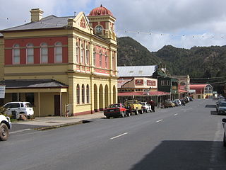
Queenstown is a town in the West Coast region of the island of Tasmania, Australia. It is in a valley on the western slopes of Mount Owen on the West Coast Range.

<span class="mw-page-title-main">King River (Tasmania)</span> River in Tasmania, Australia

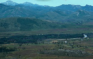
The King River is a major perennial river in the West Coast region of Tasmania, Australia.

<span class="mw-page-title-main">Lyell Highway</span> Highway in Western and Central Tasmania

The Lyell Highway is a highway in Tasmania, running from Hobart to Queenstown. It is the one of two transport routes that passes through the West Coast Range, the other being the Anthony Road.

<span class="mw-page-title-main">West Coast Range</span> Mountain range in Tasmania, Australia

The West Coast Range is a mountain range located in the West Coast region of Tasmania, Australia.

Lake Margaret is a concrete-faced gravity dam with an uncontrolled spillway across the Yolande River, located on the north side of Mount Sedgwick, in the West Coast Range, West Coast of Tasmania, Australia.

Gormanston is a town in Tasmania on the slopes of Mount Owen, above the town of Queenstown in Tasmania's West Coast. In the 2016 census, Gormanston had a population of 17.

Crotty is a former gazetted townsite that was located in Western Tasmania, Australia. The township was located on the eastern lower slopes of Mount Jukes, below the West Coast Range, and on the southern bank of the King River. The locality had had a former name of King River

<span class="mw-page-title-main">North Mount Lyell Railway</span> Former railway company in Tasmania, Australia

The North Mount Lyell Railway was built to operate between the North Mount Lyell mine in West Coast Tasmania and Pillinger in the Kelly Basin of Macquarie Harbour.

<span class="mw-page-title-main">Mount Owen (Tasmania)</span> Mountain in Tasmania, Australia

Mount Owen is a mountain directly east of the town of Queenstown on the West Coast Range in Western Tasmania, Australia.

The Mount Jukes mine sites were a series of short-lived, small mine workings high on the upper regions of Mount Jukes in the West Coast Range on the West Coast of Tasmania.

<span class="mw-page-title-main">Mount Huxley (Tasmania)</span> Mountain in Tasmania, Australia

Mount Huxley is a mountain located on the West Coast Range in the West Coast region of Tasmania, Australia. With an elevation of 926 metres (3,038 ft) above sea level, the mountain was named by Charles Gould in 1863 in honour of Professor Thomas Henry Huxley.

Mount Jukes is a mountain located on the Jukes Range, a spur off the West Coast Range, in the West Coast region of Tasmania, Australia.

<span class="mw-page-title-main">Linda Valley</span> Valley in West Coast Range, Tasmania, Australia

Linda Valley is a valley in the West Coast Range of Tasmania. It was earlier known as the Vale of Chamouni. It is located between Mount Owen and Mount Lyell.

<span class="mw-page-title-main">Crotty Dam</span> Dam in Tasmania, Australia

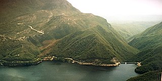
The Crotty Dam, also known during construction as the King Dam, or the King River Dam on initial approval, is a rockfill embankment dam with a controlled and uncontrolled spillway across the King River, between Mount Jukes and Mount Huxley, located in Western Tasmania, Australia.

The mines of the West Coast of Tasmania have a rich historical heritage as well as an important mineralogical value in containing or having had found, specimens of rare and unusual minerals. Also, the various mining fields have important roles in the understanding of the mineralization of the Mount Read Volcanics, and the occurrence of economic minerals.

<span class="mw-page-title-main">Darwin Dam</span> Dam in Tasmania, Australia

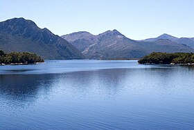
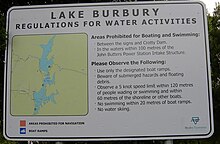
The Darwin Dam is an offstream earthfill embankment saddle dam without a spillway, located in Western Tasmania, Australia. The impounded reservoir, also formed by Crotty Dam, is called Lake Burbury.

<span class="mw-page-title-main">Linda, Tasmania</span> Town in Tasmania, Australia

Linda is the site of an old ghost town in the Linda Valley in the West Coast Range of Tasmania, Australia. It has also been known as Linda Valley.

Kelly Basin Road was a road built on the formation of the former North Lyell Railway in the King River Valley of Western Tasmania. It ran to the east of the West Coast Range, from the Linda Valley, to Kelly Basin.

<span class="mw-page-title-main">Lake Beatrice</span> Lake in West Coast Range, Tasmania, Australia

Lake Beatrice is a 55-hectare (140-acre) natural lake on the lower eastern side of Mount Sedgwick in the West Coast Range of Western Tasmania, Australia.

The John Butters Power Station is a conventional hydroelectric power station located in Western Tasmania, Australia. The power station forms part of the King – Yolande River Power Scheme and is owned and operated by Hydro Tasmania.

References

  1. Whitham, Charles (2003). Western Tasmania – A land of riches and beauty (Reprint 2003 ed.). Queenstown: Municipality of Queenstown. Whitham claimed that the 1917 proposed dam which was an earlier version of this dam should be named 'Lake Dorothy' in line with naming lakes on the Tasmanian West Coast with female names.
  2. The smaller rivers on the eastern shore include the Princess River, Nelson River; to the west the Comstock Creek flows in from the valley between Mount Lyell and Mount Sedgwick – see the Tasmania 1:100 000 map Franklin Sheet 8013 Edition 6 1997
  3. Named after the family that owned and operated the sawmill that was inundated at Princess River
  4. The Peaks of Lyell re the early survey of Huntley Clarke at the King near the confluence with the Tofft River, and also at the head of the King river gorge between Mount Owen and Mount Huxley – see p. 253 of 4th edition
  5. "Crotty Dam and Lake Burbury, Lyell Hwy, Gormanston, TAS, Australia (Place ID 101584)". Australian Heritage Database . Australian Government . Retrieved 24 May 2018.
  6. Owen: 3833 (Map) (2 ed.). 1:25,000. Tasmap. 2001.
  7. Franklin: 8013 (Map) (6 ed.). 1:100,000. Tasmap.
  8. http://anglersalliance.org.au/web-cams/lake-burbury-webcam/ – the webcam is supported by the Anglers Alliance Tasmania and the government http://www.ifs.tas.gov.au

Further reading