
The Lyell Highway is a highway in Tasmania, running from Hobart to Queenstown. It is the one of two transport routes that passes through the West Coast Range, the other being the Anthony Road.

The West Coast Range is a mountain range located in the West Coast region of Tasmania, Australia.
Lake Margaret is a concrete-faced gravity dam with an uncontrolled spillway across the Yolande River, located on the north side of Mount Sedgwick, in the West Coast Range, West Coast of Tasmania, Australia.

The West Coast of Tasmania is mainly isolated rough country, associated with wilderness, mining and tourism. It served as the location of an early convict settlement in the early history of Van Diemen's Land, and contrasts sharply with the more developed and populous northern and eastern parts of the island state.
Mount Read is a mountain located in the West Coast region of Tasmania, Australia, and is at the north west edge of the West Coast Range.
Crotty is a former gazetted townsite that was located in Western Tasmania, Australia. The township was located on the eastern lower slopes of Mount Jukes, below the West Coast Range, and on the southern bank of the King River. The locality had had a former name of King River

Mount Owen is a mountain directly east of the town of Queenstown on the West Coast Range in Western Tasmania, Australia.
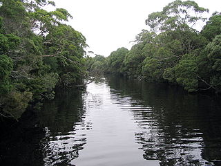
Lake Burbury is a man-made water reservoir created by the Crotty Dam inundating the upper King River valley that lies east of the West Coast Range. Discharge from the reservoir feeds the John Butters Hydroelectric Power Station, owned and operated by Hydro Tasmania.

Mount Huxley is a mountain located on the West Coast Range in the West Coast region of Tasmania, Australia. With an elevation of 926 metres (3,038 ft) above sea level, the mountain was named by Charles Gould in 1863 in honour of Professor Thomas Henry Huxley.
Mount Jukes is a mountain located on the Jukes Range, a spur off the West Coast Range, in the West Coast region of Tasmania, Australia.
Mount Sedgwick is a mountain located within the West Coast Range, in the West Coast region of Tasmania, Australia.
The Henty River is a perennial river in the West Coast region of Tasmania, Australia. The river generally lies north of Queenstown and south of Zeehan.

Mount Murchison is a mountain on the West Coast Range, located in the West Coast region of Tasmania, Australia.
Mount Geikie is a mountain in the West Coast Range of Western Tasmania, Australia.
South West Tasmania is a region in Tasmania that has evoked curiosity as to its resources over the duration of European presence on the island.
Lake Dora is a 48-hectare (120-acre) lake and also short-lived mining area of the late 1890s located in the West Coast Range of Western Tasmania, Australia. It has a surface level of 756 metres (2,480 ft) AHD .
Lake Beatrice is a 55-hectare (140-acre) natural lake on the lower eastern side of Mount Sedgwick in the West Coast Range of Western Tasmania, Australia.
Lake Selina is a natural glacial lake located to the east of Mount Read, in the West Coast Range, on the west coast of Tasmania, Australia.
The Anthony Road is a major B Route in Western Tasmania, running from the Murchison Highway (A10) at Tullah to the Zeehan Highway (A10) north of Queenstown.

The Tyndall Range, commonly called The Tyndalls, is a mountain range that is part of the West Coast Range located in the Western region of Tasmania, Australia.
