Mount Owen (Tasmania)

Last updated

Mount Owen
Lake Burbury.jpg
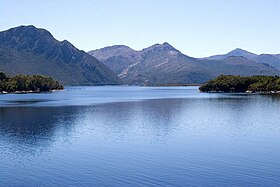
East Mount Owen wall and Lake Burbury from Bradhsaws Bridge
Highest point
Elevation 1,146 m (3,760 ft) [1]
Prominence 774 m (2,539 ft) [1]
Isolation 8.53 km (5.30 mi) [1]
Coordinates 42°05′24″S145°36′00″E / 42.09000°S 145.60000°E / -42.09000; 145.60000 (Mount Owen) Coordinates: 42°05′24″S145°36′00″E / 42.09000°S 145.60000°E / -42.09000; 145.60000 (Mount Owen) [2]
Geography
Relief Map of Tasmania.png
Red triangle with thick white border.svg
Mount Owen
Location in Tasmania
Location West Coast, Tasmania, Australia
Parent range West Coast Range
Climbing
Easiest route from North West along track to TV tower

Mount Owen is a mountain directly east of the town of Queenstown on the West Coast Range in Western Tasmania, Australia.

Contents

With an elevation of 1,146 metres (3,760 ft) above sea level, [1] like most of the mountains in the West Coast Range, it was named by the geologist Charles Gould after Richard Owen. The taller mountains were named after opponents or critics of Charles Darwin, the smaller after his supporters. The north western slopes are clearly seen from Gormanston and the Linda Valley 'Long Spur'. [3]

Features and access

Historically, the tree line on Mount Owen was to a high level. However, timber on the slopes was used by the local mining operations. In the early days of settlement, fires started on the slopes destroyed housing in Queenstown [4] and threatened the North Mount Lyell Railway. [5]

By the early twentieth century, the slopes of Mount Owen were denuded and had limited remnant vegetation. [6] [7]

A map in Geoffrey Blainey's The Peaks of Lyell , sourced from 1900–1910, calls the north west peak the 'North Spur'. The northern slopes, clearly visible from the Lyell Highway passing through the Linda Valley, show the extent of degradation due to fire, smelter fumes and heavy rainfall. It has small glacial lakes on its upper eastern slope, indicating the extent of glaciation in the King River valley. The western slopes loom over Queenstown and in winter are regularly covered in snow. The eastern wall to its north eastern peak hangs over the western shore of Lake Burbury and, in earlier times, the North Mount Lyell Railway which passed beneath.

In the late 1890s a number of mining ventures that utilized proximity to mining leases with the name Mount Lyell as an attractor of investment, tried to elicit interest in leases on the lower slope of Mount Owen. [8] [9]

Current conditions

There are TV and communications towers on its north west peak (North Spur), which has been used a vehicle access track. Other geological features near Mount Owen include Mount Lyell to the north and Mount Huxley to the south.

Mount Owen is accessible on foot along a formed four wheel track. As early as 1938 suggestions were made to create a formed track for tourists and visitors. [10]

The surface is gravel and rocks. It is a moderate to hard walk and takes about 4 hours including the return trip. The walk starts at Karlson's Gap, the saddle between Gormanston and Mt Owen. [11]

See also

Related Research Articles

<span class="mw-page-title-main">Queenstown, Tasmania</span> Town in Tasmania, Australia

Queenstown is a town in the West Coast region of the island of Tasmania, Australia. It is in a valley on the western slopes of Mount Owen on the West Coast Range.

<span class="mw-page-title-main">West Coast Range</span> Mountain range in Tasmania, Australia

The West Coast Range is a mountain range located in the West Coast region of Tasmania, Australia.

Mount Lyell is a mountain in the West Coast Range of Western Tasmania, Australia.

<span class="mw-page-title-main">Regatta Point, Tasmania</span> Port and locality in Western Tasmania, Australia

Regatta Point is the location of a port and rail terminus on Macquarie Harbour.

Gormanston is a town in Tasmania on the slopes of Mount Owen, above the town of Queenstown in Tasmania's West Coast. At the 2016 Gormanston had a population of 17.

Mount Read is a mountain located in the West Coast region of Tasmania, Australia, and is at the north west edge of the West Coast Range.

Crotty is a former gazetted townsite that was located in Western Tasmania, Australia. The township was located on the eastern lower slopes of Mount Jukes, below the West Coast Range, and on the southern bank of the King River. The locality had had a former name of King River

<span class="mw-page-title-main">North Mount Lyell Railway</span> Former railway company in Tasmania, Australia

The North Mount Lyell Railway was built to operate between the North Mount Lyell mine in West Coast Tasmania and Pillinger in the Kelly Basin of Macquarie Harbour.

<span class="mw-page-title-main">Queen River, Tasmania</span> River in Tasmania, Australia

The Queen River, part of the King River catchment, is a minor perennial river located in the West Coast region of Tasmania, Australia.

The Mount Jukes Mine sites were a series of short-lived, small mine workings high on the upper regions of Mount Jukes in the West Coast Range on the West Coast of Tasmania.

<span class="mw-page-title-main">Mount Huxley (Tasmania)</span> Mountain in Tasmania, Australia

Mount Huxley is a mountain located on the West Coast Range in the West Coast region of Tasmania, Australia. With an elevation of 926 metres (3,038 ft) above sea level, the mountain was named by Charles Gould in 1863 in honour of Professor Thomas Henry Huxley.

Mount Jukes is a mountain located on the Jukes Range, a spur off the West Coast Range, in the West Coast region of Tasmania, Australia.

North Mount Lyell was the name of a mine, mining company, locality and former railway north of Gormanston on the southern slopes of Mount Lyell in the West Coast Range on the West Coast of Tasmania, and on to the ridge between Mount Lyell and Mount Owen.

<span class="mw-page-title-main">Linda Valley</span> Valley in West Coast Range, Tasmania, Australia

Linda Valley is a valley in the West Coast Range of Tasmania. It was earlier known as the Vale of Chamouni. It is located between Mount Owen and Mount Lyell.

<span class="mw-page-title-main">Mount Sedgwick (Tasmania)</span> Mountain in Tasmania, Australia

Mount Sedgwick is a mountain located within the West Coast Range, in the West Coast region of Tasmania, Australia.

The history of the Railways on the West Coast of Tasmania has fascinated enthusiasts from around the world, because of the combination of the harsh terrain in which the railways were created, and the unique nature of most of the lines.

<span class="mw-page-title-main">Linda, Tasmania</span> Town in Tasmania, Australia

Linda is the site of an old ghost town in the Linda Valley in the West Coast Range of Tasmania, Australia. It has also been known as Linda Valley.

Mount Dundas is a mountain located in the West Coast region of Tasmania, Australia. The mountain is situated at the north west edge of the West Coast Range.

James Crotty (1845–1898) was an Irish-born Australian mining prospector who formed a mining company, the North Mount Lyell mining company, in the western region of Tasmania, just before the turn of the twentieth century.

<span class="mw-page-title-main">Philosophers Ridge</span> Ridge in Western Tasmania, Australia

Philosophers Ridge is the long spur that connects Mount Lyell and Mount Owen in the West Coast Range of Western Tasmania.

References

  1. 1 2 3 4 "Mount Owen, Australia". Peakbagger.com. Retrieved 16 June 2015.
  2. "Mount Owen (TAS)". Gazetteer of Australia online. Geoscience Australia, Australian Government.
  3. Baillie, Peter (2010). "The West Coast Range, Tasmania: Mountains and Geological Giants" (PDF). Papers and Proceedings of the Royal Society of Tasmania (reprint ed.). Hobart, Tasmania: University of Tasmania. 144: 1–13. doi:10.26749/rstpp.144.1. ISSN   0080-4703. S2CID   126902525. Archived from the original (PDF) on 16 June 2015. Retrieved 18 June 2015.
  4. "BUSH FIRES IN TASMANIA". The Brisbane Courier . National Library of Australia. 27 December 1899. p. 5. Retrieved 5 June 2012.
  5. "FIRES IN TASMANIA." The Advertiser . Adelaide: National Library of Australia. 9 October 1914. p. 11. Retrieved 5 June 2012.
  6. "LYELL DISTRICT DESCRIBED". Zeehan and Dundas Herald . Hobart, Tas.: National Library of Australia. 12 September 1917. p. 1. Retrieved 5 June 2012.
  7. "FLORA AND FAUNA". The Mercury . Hobart, Tas.: National Library of Australia. 22 July 1933. p. 3. Retrieved 5 June 2012.
  8. "MINING MEETINGS". The Age . No. 12887. Victoria, Australia. 19 June 1896. p. 7. Retrieved 10 October 2017 via National Library of Australia.
  9. "MOUNT OWEN LYELL EXTENDED COMPANY". Launceston Examiner . Vol. LVII, no. 277. Tasmania, Australia. 23 November 1897. p. 3. Retrieved 10 October 2017 via National Library of Australia.
  10. "Track to Summit of Mount Owen". The Examiner (Tasmania) . Vol. XCVII, no. 83. Tasmania, Australia. 18 June 1938. p. 5 (LATE NEWS EDITION and DAILY). Retrieved 10 October 2017 via National Library of Australia.
  11. "Archived copy" (PDF). Archived from the original (PDF) on 19 February 2017. Retrieved 3 January 2017.{{cite web}}: CS1 maint: archived copy as title (link)

Further reading