Giblin Peak

Last updated

Giblin Peak
Relief Map of Tasmania.png
Red triangle with thick white border.svg
Giblin Peak
Location in Tasmania
Highest point
Elevation 1,569 m (5,148 ft) [1] [2]
Prominence 9 m (30 ft) [2]
Isolation 0.34 km (0.21 mi) [2]
Listing 3rd highest mountain in Tasmania [2]
Coordinates 41°31′48″S147°39′00″E / 41.53000°S 147.65000°E / -41.53000; 147.65000 Coordinates: 41°31′48″S147°39′00″E / 41.53000°S 147.65000°E / -41.53000; 147.65000 [3]
Geography
LocationNortheast Tasmania, Australia
Parent range Ben Lomond

The Giblin Peak is a mountain of the Ben Lomond mountain range in northeast Tasmania, Australia. [4] It is the highest elevation on Giblin Fells, a prominent bluff south of Ben Lomond's highest elevation - Legges Tor.

Mountain A large landform that rises fairly steeply above the surrounding land over a limited area

A mountain is a large landform that rises above the surrounding land in a limited area, usually in the form of a peak. A mountain is generally steeper than a hill. Mountains are formed through tectonic forces or volcanism. These forces can locally raise the surface of the earth. Mountains erode slowly through the action of rivers, weather conditions, and glaciers. A few mountains are isolated summits, but most occur in huge mountain ranges.

Ben Lomond (Tasmania) plateau in the north of Tasmania

Ben Lomond is a mountain in the north-east of Tasmania, Australia.

Mountain range A geographic area containing several geologically related mountains

A mountain range or hill range is a series of mountains or hills ranged in a line and connected by high ground. A mountain system or mountain belt is a group of mountain ranges with similarity in form, structure, and alignment that have arisen from the same cause, usually an orogeny. Mountain ranges are formed by a variety of geological processes, but most of the significant ones on Earth are the result of plate tectonics. Mountain ranges are also found on many planetary mass objects in the Solar System and are likely a feature of most terrestrial planets.

Contents

With an elevation of 1,569 metres (5,148 ft) above sea level, it is the third highest mountain in Tasmania [2] and named after William Giblin, a previous Premier of Tasmania. [5] [6] [7] [8]

The Australian Height Datum is a vertical datum in Australia. According to Geoscience Australia, "In 1971 the mean sea level for 1966-1968 was assigned the value of 0.000m on the Australian Height Datum at thirty tide gauges around the coast of the Australian continent. The resulting datum surface, with minor modifications in two metropolitan areas, has been termed the Australian Height Datum (AHD) and was adopted by the National Mapping Council as the datum to which all vertical control for mapping is to be referred."

William Giblin Australian politician

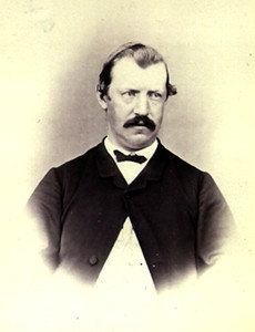
William Robert Giblin was Premier of Tasmania (Australia) from 5 March 1878 until 20 December 1878 and from 1879 until 1884.

Before the northern aspect of the Ben Lomond plateau was surveyed, Stacks Bluff (at the plateau's southern extremity) was thought to be the highest elevation on the Ben Lomond plateau. From 1905 to 1912 a full survey of Ben Lomond was conducted by Colonel W.V. Legge and his survey party. The survey party explored the highlands on the north of the plateau in 1907. Legge had long suspected that the north of the plateau was higher than the trigonometric station on Stacks Bluff although it is less obviously elevated from casual observation. Moreover, the area was, at the time, an area so remote and unexplored that Legge described it as 'untrodden as the distant ranges of the west coast'. [7] Lyndhurst Giblin, a member of Legge's survey party, climbed and measured the true summit and named it after Legge and, in turn, the prominent bluff to the south of the summit was named for Giblin's father - Giblin Fells. [7] [8]

Stacks Bluff mountain in Australia

The Stacks Bluff is a peak in northeast Tasmania, Australia. The mountain is situated on the Ben Lomond plateau.

William Vincent Legge Australian ornithologist

Colonel William Vincent Legge was an Australian soldier and an ornithologist who documented the birds of Sri Lanka. Legge's hawk-eagle is named after him as is Legges Tor, the second highest peak in Tasmania.

Lyndhurst Falkiner Giblin DSO MC was an Australian statistician and economist. He was an unsuccessful gold prospector, played rugby union for England, and fought in the First World War.

See also

Related Research Articles

Mount Ossa (Tasmania) mountain in Tasmania

Mount Ossa is the highest mountain in Tasmania with a summit elevation of 1,617 metres (5,305 ft) above sea level. It makes up part of the Pelion Range within Cradle Mountain-Lake St Clair National Park in the Central Highlands region of Tasmania, Australia.

Great Western Tiers mountain range

The Great Western Tiers are a collection of mountain bluffs that form the northern edge of the Central Highlands plateau in Tasmania, Australia. The bluffs are contained within the Tasmanian Wilderness World Heritage Site.

Federation Peak mountain in Tasmania, Australia

Federation Peak is a prominent Tasmanian mountain that marks the end of the Eastern Arthur Range, in the Southwest National Park. It is well known for its distinctive sharp spire-like shape. The peak, approximately 90 kilometres (56 mi) south-west from Hobart, was named after the Federation of Australia.

Eldon Range mountain range

The Eldon Range is a mountain range located in the west coast region of Tasmania, Australia.

Barn Bluff Mountain in Tasmania, Australia

Barn Bluff is a mountain located in the Central Highlands region of Tasmania, Australia. The mountain is situated in the Cradle Mountain-Lake St Clair National Park at the junction of the eastern most points of the Murchison and Mackintosh river catchments.

Legges Tor mountain

The Legges Tor is the summit of the Ben Lomond mountain range in northeast Tasmania, Australia.

Mount Arthur (Tasmania) mountain

Mount Arthur is a mountain in the northern region of Tasmania, Australia. With an elevation of 1,188 metres (3,898 ft) above sea level, the mountain is located north-east of Launceston, near the town of Lilydale.

Mount Geryon Mountain in Australia

Mount Geryon is a mountain in the Central Highlands region of the Australian state of Tasmania. The mountain is part of the Du Cane Range and is situated within the Cradle Mountain-Lake St Clair National Park.

Mount Victoria (Tasmania) mountain in Tasmania, Australia

Mount Victoria is a mountain in the Mount Victoria Forest Reserve in north-east Tasmania, Australia, and also forms part of the Ben Lomond biogeographic region and the Ben Lomond National Park. The peak has an elevation of 1,213 metres (3,980 ft) above sea level and is the 58th highest mountain in Tasmania. It is a prominent feature of the reserve, and is a popular venue with bushwalkers.

Mount Barrow mountain in Australia

Mount Barrow is a mountain in the northern region of Tasmania, Australia. With an elevation of 1,406 metres (4,613 ft) above sea level, the mountain is located 22 kilometres (14 mi) east-north-east of Launceston. The mountain habitat is a mixture of temperate old growth rainforest, subalpine and alpine landscapes.

Skiing in Tasmania overview of skiing practiced in Tasmania

Skiing in Tasmania takes place in the high country of the state of Tasmania, Australia, during the Southern Hemisphere winter. Cross country skiing is possible within the Tasmanian Wilderness and two small downhill ski-fields have been developed at Ben Lomond and Mount Mawson.

Markham Heights mountain in Australia

Markham Heights is a mountain peak that forms part of the Ben Lomond Range, in the northeast of Tasmania, Australia.

References

  1. "LISTmap (Giblin Peak)". Tasmanian Government Department of Primary Industries and Water. Retrieved 5 June 2015.
  2. 1 2 3 4 5 "Giblin Peak, Australia". Peakbagger.com. Retrieved 5 June 2015.
  3. "Giblin Peak (TAS)". Gazetteer of Australia online. Geoscience Australia, Australian Government.
  4. "Giblin Peak". Placenames Tasmania. Department of Primary Industries, Parks, Water and Environment, Government of Tasmania.
  5. Cain, Neville (1981). "Giblin, Lyndhurst Falkiner (1872–1951)". Australian Dictionary of Biography . 8. Canberra: Australian National University. Retrieved 5 June 2015.
  6. Giblin, L. F.; Piesse, E. L. (1913). "The Height of Ben Lomond" (PDF). Proceedings of the Royal Society of Tasmania: 5–13.
  7. 1 2 3 W.V. Legge (14 Jun 1907). [trove.nla.gov.au "The Ben Lomond plateau. Discovery of high land at the north end"]. The Examiner. Retrieved 20 February 2016.
  8. 1 2 "Legge's Tor highest peak". The Examiner. 24 Aug 1946. Retrieved 27 July 2015.