Tyndall Range

Last updated

Tyndall Range
The Tyndalls
West Coast Range - from above Tyndalls looking south.jpg
Aerial photograph of Tyndalls area
Highest point
Peak Mount Tyndall
Elevation 1,179 m (3,868 ft)
AHD
Coordinates 41°55′48″S145°35′24″E / 41.93000°S 145.59000°E / -41.93000; 145.59000 [1]
Geography
Relief Map of Tasmania.png
Red triangle with thick white border.svg
Location in Tasmania
CountryAustralia
State Tasmania
Region Western Tasmania
Range coordinates 41°56′24″S145°35′24″E / 41.94000°S 145.59000°E / -41.94000; 145.59000 Coordinates: 41°56′24″S145°35′24″E / 41.94000°S 145.59000°E / -41.94000; 145.59000 [2]
Parent range West Coast Range
Geology
Age of rock Jurassic
Type of rock Dolerite

The Tyndall Range, commonly called The Tyndalls, is a mountain range that is part of the West Coast Range located in the Western region of Tasmania, Australia.

Contents

The main focal point for the range is Mount Tyndall which lies at the northern part of the range. The whole range western slopes can be viewed from the Anthony Road, while the plateau like formation of The Tyndalls is a road free area requiring viewing either from the air, or by foot.

Within the range lies the Tyndall Regional Reserve, a nature reserve that is the western buffer zone for the Cradle Mountain-Lake St Clair National Park World Heritage Area. [3] The area is north of Mount Sedgwick.

The Tyndalls were named in 1877 by James Reid Scott on the suggestion of Thomas Bather Moore in honour of Professor John Tyndall, a Fellow of the Geological Society who made important contributions in physics, atmospheric science and geology. [4]

Features

The Tyndall Range have a number of glacial lakes, the larger being Lake Huntley, Lake Rolleston, Lake Tyndall and Lake Matthew. The signs of the glaciation were first described by Thomas Bather Moore in 1894. [5] [6] [7]

The Tyndalls were explored for minerals in the early twentieth century, but no significant working mine ever eventuated. [8] [9]

The Tyndalls lie south east of the Henty Gold Mine, and Hydro Tasmania dam on the upper Henty River and south of Lake Mackintosh, Lake Murchison and Tullah. They are west of the Sticht Range.

See also

Related Research Articles

<span class="mw-page-title-main">West Coast Range</span> Mountain range in Tasmania, Australia

The West Coast Range is a mountain range located in the West Coast region of Tasmania, Australia.

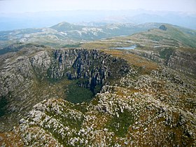
Mount Read is a mountain located in the West Coast region of Tasmania, Australia, and is at the north west edge of the West Coast Range.

<span class="mw-page-title-main">Mount Owen (Tasmania)</span> Mountain in Tasmania, Australia

Mount Owen is a mountain directly east of the town of Queenstown on the West Coast Range in Western Tasmania, Australia.

The Mount Jukes mine sites were a series of short-lived, small mine workings high on the upper regions of Mount Jukes in the West Coast Range on the West Coast of Tasmania.

Mount Darwin is a mountain located in the West Coast region of Tasmania, Australia.

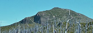
Mount Jukes is a mountain located on the Jukes Range, a spur off the West Coast Range, in the West Coast region of Tasmania, Australia.

<span class="mw-page-title-main">Linda Valley</span> Valley in West Coast Range, Tasmania, Australia

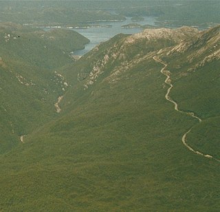
Linda Valley is a valley in the West Coast Range of Tasmania. It was earlier known as the Vale of Chamouni. It is located between Mount Owen and Mount Lyell.

<span class="mw-page-title-main">Mount Sedgwick (Tasmania)</span> Mountain in Tasmania, Australia

Mount Sedgwick is a mountain located within the West Coast Range, in the West Coast region of Tasmania, Australia.

The mines of the West Coast of Tasmania have a rich historical heritage as well as an important mineralogical value in containing or having had found, specimens of rare and unusual minerals. Also, the various mining fields have important roles in the understanding of the mineralization of the Mount Read Volcanics, and the occurrence of economic minerals.

Mount Tyndall is a mountain that is part of the Tyndall Range, a spur off the West Coast Range, located in the Western region of Tasmania, Australia.

Thomas Bather Moore was a pioneer explorer of Western and South West, Tasmania, Australia.

<span class="mw-page-title-main">Henty River</span> River in Western Tasmania, Australia

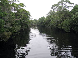
The Henty River is a perennial river in the West Coast region of Tasmania, Australia. The river generally lies north of Queenstown and south of Zeehan.

<span class="mw-page-title-main">Mount Murchison (Tasmania)</span> Mountain in West Coast Range, Western Tasmania, Australia

Mount Murchison is a mountain on the West Coast Range, located in the West Coast region of Tasmania, Australia.

Mount Strahan is a mountain located on the West Coast Range in the West Coast region of Tasmania, Australia. With an elevation of 855 metres (2,805 ft) above sea level, the mountain is situated directly east of Macquarie Harbour and, like Mount Sorell, dominates the east side of the harbour near Sarah Island.

Mount Dundas is a mountain located in the West Coast region of Tasmania, Australia. The mountain is situated at the north west edge of the West Coast Range.

Mount Geikie is a mountain in the West Coast Range of Western Tasmania, Australia.

The Sticht Range is a mountain range located in the West Coast region of Tasmania, Australia. The range runs between two tributaries of the Eldon River and is located within the eastern part of the West Coast Range and has an unnamed peak with an elevation of 1,080 metres (3,540 ft) above sea level.

The Mount Read Volcanics is a Cambrian volcanic belt that exists in Western Tasmania.

<span class="mw-page-title-main">Lake Beatrice</span> Lake in West Coast Range, Tasmania, Australia

Lake Beatrice is a 55-hectare (140-acre) natural lake on the lower eastern side of Mount Sedgwick in the West Coast Range of Western Tasmania, Australia.

Lake Westwood is a 35-hectare (86-acre) glacial lake in the Tyndalls peaks to the east of Mount Read, in the West Coast Range, West Coast of Tasmania.

References

  1. "Mount Tyndall (TAS)". Gazetteer of Australia online. Geoscience Australia, Australian Government.
  2. "Tyndall Range (TAS)". Gazetteer of Australia online. Geoscience Australia, Australian Government.
  3. Tyndall (Map) (2 ed.). Tasmap. 2007. Sheet 3835.
  4. Baillie, Peter (2010). "The West Coast Range, Tasmania: Mountains and Geological Giants" (PDF). Papers and Proceedings of the Royal Society of Tasmania (reprint ed.). Hobart, Tasmania: University of Tasmania. 144: 1–13. ISSN   0080-4703 . Retrieved 18 June 2015.
  5. Moore, Thomas Bather (1893), Discovery of glaciation in the vicinity of mount Tyndall, in Tasmania , retrieved 21 June 2015
  6. "CURRENT TOPICS". Launceston Examiner . Tas. 22 June 1894. p. 4. Retrieved 9 June 2012 via National Library of Australia.
  7. Bowden, Adrian Russell (1974), The glacial geomorphology of the Tyndall Mountains, western Tasmania , retrieved 21 June 2015
  8. "AN ABANDONED DISTRICT". The Examiner (DAILY ed.). Launceston, Tasmania. 12 March 1909. p. 2. Retrieved 23 February 2012 via National Library of Australia.
  9. White, Matthew J (1996), Stratigraphy, volcanology and sedimentology of the Cambrian Tyndall Group, Mount Read volcanics, western Tasmania , retrieved 21 June 2015

Further reading