Lake Margaret (Tasmania)

Last updated

Lake Margaret
Relief Map of Tasmania.png
Red pog.svg
Location in Tasmania
CountryAustralia
Location West Coast, Tasmania
Coordinates 41°59′30.3″S145°35′15″E / 41.991750°S 145.58750°E / -41.991750; 145.58750
Purpose Power
StatusOperational
Opening date1918
Built by Mount Lyell Mining and Railway Company
Owner(s) Hydro Tasmania
Dam and spillways
Type of dam Gravity dam
Impounds Yolande River
Height (foundation)17 m (56 ft)
Length243 m (797 ft)
Dam volume6,000 m3 (210,000 cu ft)
Spillways 1
Spillway type Uncontrolled
Spillway capacity29 m3/s (1,000 cu ft/s)
Reservoir
CreatesLake Margaret
Catchment area 21 km2 (8.1 sq mi)
Surface area170 ha (420 acres)
Normal elevation660 m (2,170 ft) AHD
Lake Margaret Power Station
Operator(s)Hydro Tasmania
Commission date
  1. 1914 1930
  2. 1931; 2010
Decommission date
  1. Continual use
  2. 1994; since recommissioned
Type Conventional
Turbines
Installed capacity
  1. 8.3 MW (11,100 hp)
  2. 3.2 MW (4,300 hp)
Annual generation 48 GWh (170 TJ)
[1] [2] [3]

Lake Margaret is a concrete-faced gravity dam with an uncontrolled spillway across the Yolande River, located on the north side of Mount Sedgwick, in the West Coast Range, West Coast of Tasmania, Australia.

Contents

The impounded reservoir is also called Lake Margaret. [1]

The dam was constructed in 1918 by the Mount Lyell Mining and Railway Company for the purpose of generating hydro-electric power via the Lake Margaret Power Station, which is located below the dam wall. Following the closure of the Mount Lyell Mining and Railway Company, in 1985 the control of the dam, lake, and power station was transferred to Hydro Tasmania. [2]

Features and location

The dam, called Lake Margaret, was completed in 1918 and it was the first gravity dam constructed in Tasmania. It was built of concrete with conglomerate "plums". The dam wall is 17 metres (56 ft) high and is 243 metres (797 ft) long and the concrete-faced dam wall has a volume of 6,000 cubic metres (210,000 cu ft). The uncontrolled spillway has a capacity of 29 cubic metres per second (1,000  cu ft/s ). In 1974 the dam wall was strengthened by the use of prestressed anchors and grouting of open joints. [1]

The Lake Margaret dam impounds the Yolande River, which also is the outflow from the dam. Further west the Yolande joins with the Langdon River, another West Coast Range west flowing river, to join with the Henty River west of the Zeehan Highway.

Reservoir

The 170-hectare (420-acre) reservoir, [3] also called Lake Margaret, with an elevation of 660 metres (2,170 ft) AHD , lies east of Mount Cyril, that has an elevation of 797 metres (2,615 ft), and south of Mount Geikie, that has an elevation of 1,191 metres (3,907 ft), both in the West Coast Range. Mount Sedgwick is to the south. The Bastion, at 1,107 metres (3,632 ft), which is a steep cliff face that is immediately west of Lake Magdala and north of Mount Geikie, together with Farquhar Lookout, with an elevation of 935 metres (3,068 ft), define a rough line of the northern part of the 21-square-kilometre (8.1 sq mi) catchment area.

Numerous smaller lakes – some named and some not – lie above the location of the Lake Margaret. The vesting of the catchment with the current operator of the hydro electric power station, makes the two feeder parts of the catchment specific Hydro land in contrast to the surrounding landscape which is either in the Tyndall Regional Reserve or the Lake Beatrice Conservation Area. [4] [5]

The two southern feeder Hydro reserves start from the slopes of Mount Sedgwick, the westerly from Lake Barnables (less than one kilometre (zero point six two miles) east of Lake Margaret), then to Lake Phillip. The eastern feeder starts at an unnamed lake to Lake Polycarp, Lake Peter, Lake Paul, Lake Apollos, and then to Lake Phillip. The northern feeder starts from Lake Monica, Lake Myra, then Lake Magdala, situated at 782 metres (2,566 ft) AHD , Lake Martha, at 757 metres (2,484 ft), and Lake Mary, at 732 metres (2,402 ft), before flowing into Lake Margaret. [4] [5]

The larger lower altitude natural lake of the area lies to the south east side of Mount Sedgwick and is known as Lake Beatrice.

Power scheme

The initial purpose of Lake Margaret when it was constructed by the Mount Lyell Mining and Railway Company was to generate hydroelectric power for the Queenstown-based Mount Lyell mine, railway, and surrounding community. While the mine has since closed, the purpose of Lake Margaret to generate power remains unchanged. Between 1918 and 1930 the Mount Lyell Mining and Railway Company commissioned seven conventional Pelton turbine generators with a capacity of 8.3 megawatts (11,100  hp ) at the Upper Lake Margaret Power Station. Hydro Tasmania took ownership of the power station in 1985. Water travels from Lake Margaret through a woodstave 2.2-kilometre (1.4 mi) pipeline to the power station. [2]

In 1931 a minihydro plant was constructed to provide additional power. The single Turgo turbine generates 3.2-megawatt (4,300 hp). Hydro Tasmania took ownership of the power station in 1985 and decommissioned the plant in 1994. The station was reopened in 2010 following refurbishment that included a new penstock, turbine and woodstave pipeline. [2]

See also

Related Research Articles

<span class="mw-page-title-main">Queenstown, Tasmania</span> Town in Tasmania, Australia

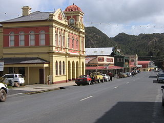
Queenstown is a town in the West Coast region of the island of Tasmania, Australia. It is in a valley on the western slopes of Mount Owen on the West Coast Range.

<span class="mw-page-title-main">King River (Tasmania)</span> River in Tasmania, Australia

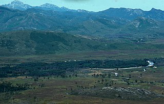
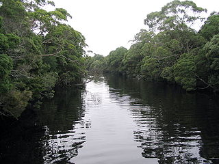
The King River is a major perennial river in the West Coast region of Tasmania, Australia.

The Lake Margaret Power Stations comprise two hydroelectric power stations located in Western Tasmania, Australia. The power stations are part of the King – Yolande Power Scheme and are owned and operated by Hydro Tasmania. Officially the Upper Lake Margaret Power Station, a conventional hydroelectric power station, and the Lower Lake Margaret Power Station, a mini-hydroelectric power station, the stations are generally collectively referred to in the singular format as the Lake Margaret Power Station. The stations are located approximately 2.5 kilometres (1.6 mi) apart.

<span class="mw-page-title-main">West Coast Range</span> Mountain range in Tasmania, Australia

The West Coast Range is a mountain range located in the West Coast region of Tasmania, Australia.

Mount Lyell is a mountain in the West Coast Range of Western Tasmania, Australia.

Gormanston is a town in Tasmania on the slopes of Mount Owen, above the town of Queenstown in Tasmania's West Coast. In the 2016 census, Gormanston had a population of 17.

Crotty is a former gazetted townsite that was located in Western Tasmania, Australia. The township was located on the eastern lower slopes of Mount Jukes, below the West Coast Range, and on the southern bank of the King River. The locality had had a former name of King River

<span class="mw-page-title-main">Lake Margaret Tram</span> Former tramway in Western Tasmania, Australia

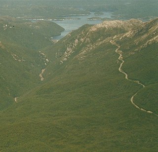
The Lake Margaret Tram was located on the western side of Mount Sedgwick in the West Coast Range on the West Coast of Tasmania in service for the Mount Lyell Mining and Railway Company to the Lake Margaret community.

<span class="mw-page-title-main">Lake Burbury</span> Lake in Tasmania, Australia

Lake Burbury is a man-made water reservoir created by the Crotty Dam inundating the upper King River valley that lies east of the West Coast Range. Discharge from the reservoir feeds the John Butters Hydroelectric Power Station, owned and operated by Hydro Tasmania.

<span class="mw-page-title-main">Mount Huxley (Tasmania)</span> Mountain in Western Tasmania, Australia

Mount Huxley is a mountain located on the West Coast Range in the West Coast region of Tasmania, Australia. With an elevation of 926 metres (3,038 ft) above sea level, the mountain was named by Charles Gould in 1863 in honour of Professor Thomas Henry Huxley.

<span class="mw-page-title-main">Mount Jukes (Tasmania)</span> Mountain in Western Tasmania, Australia

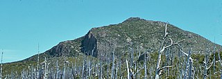
Mount Jukes is a mountain located on the Jukes Range, a spur off the West Coast Range, in the West Coast region of Tasmania, Australia.

<span class="mw-page-title-main">Crotty Dam</span> Dam in Western Tasmania, Australia

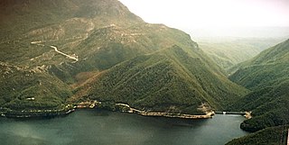
The Crotty Dam, also known during construction as the King Dam, or the King River Dam on initial approval, is a rockfill embankment dam with a controlled and uncontrolled spillway across the King River, between Mount Jukes and Mount Huxley, located in Western Tasmania, Australia.

<span class="mw-page-title-main">Mount Sedgwick (Tasmania)</span> Mountain in Tasmania, Australia

Mount Sedgwick is a mountain located within the West Coast Range, in the West Coast region of Tasmania, Australia.

<span class="mw-page-title-main">Darwin Dam</span> Dam in Tasmania, Australia

The Darwin Dam is an offstream earthfill embankment saddle dam without a spillway, located in Western Tasmania, Australia. The impounded reservoir, also formed by Crotty Dam, is called Lake Burbury.

<span class="mw-page-title-main">Henty River</span> River in Western Tasmania, Australia

The Henty River is a perennial river in the West Coast region of Tasmania, Australia. The river generally lies north of Queenstown and south of Zeehan.

Mount Geikie is a mountain in the West Coast Range of Western Tasmania, Australia.

The Anthony Power Development Scheme, part of the Pieman River power development scheme, was a proposed scheme for damming parts of the upper catchment of the Pieman River in Western Tasmania, Australia.

<span class="mw-page-title-main">Lake Beatrice</span> Lake in West Coast Range, Tasmania, Australia

Lake Beatrice is a 55-hectare (140-acre) natural lake on the lower eastern side of Mount Sedgwick in the West Coast Range of Western Tasmania, Australia.

The John Butters Power Station is a conventional hydroelectric power station located in Western Tasmania, Australia. The power station forms part of the King – Yolande River Power Scheme and is owned and operated by Hydro Tasmania.

Zeehan Highway is a road between Zeehan and Queenstown in Western Tasmania.

References

  1. 1 2 3 "Register of Large Dams in Australia" (Excel (requires download)). The Australian National Committee on Large Dams Incorporated. 2012. Retrieved 25 May 2018.
  2. 1 2 3 4 "King – Yolande". Energy: Our power stations. Hydro Tasmania . Retrieved 25 May 2018.
  3. 1 2 "Map of Lake Margaret, TAS". Bonzle Digital Atlas of Australia. n.d. Retrieved 25 May 2018.
  4. 1 2 "Gormanston" (Map). Tasmap . 2001. Sheet Sheet 3834.
  5. 1 2 "Tyndall" (Map). Tasmap . 2007. Sheet Sheet 3835.

Further reading