
West Coast Council is a local government body in Tasmania, covering much of the western region of the state. West Coast is classified as a rural local government area and has a population of 4,167. The major towns and localities of the region include Strahan, Rosebery, Zeehan and the principal town of Queenstown.

Zeehan is a town on the west coast of Tasmania, Australia 139 kilometres (86 mi) south-west of Burnie. It is part of the West Coast Council, along with the seaport Strahan, and neighbouring mining towns of Dundas, Rosebery and Queenstown.

The Lyell Highway is a highway in Tasmania, running from Hobart to Queenstown. It is the one of two transport routes that passes through the West Coast Range, the other being the Anthony Road.
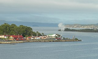
Regatta Point is the location of a port and rail terminus on Macquarie Harbour.

The Queen River, part of the King River catchment, is a minor perennial river located in the West Coast region of Tasmania, Australia.

The Lake Margaret Tram was located on the western side of Mount Sedgwick in the West Coast Range on the West Coast of Tasmania in service for the Mount Lyell Mining and Railway Company to the Lake Margaret community.
The Mount Jukes Mine sites were a series of short-lived, small mine workings high on the upper regions of Mount Jukes in the West Coast Range on the West Coast of Tasmania.
North Mount Lyell was the name of a mine, mining company, locality and former railway north of Gormanston on the southern slopes of Mount Lyell in the West Coast Range on the West Coast of Tasmania, and on to the ridge between Mount Lyell and Mount Owen.
The mines of the West Coast of Tasmania have a rich historical heritage as well as an important mineralogical value in containing or having had found, specimens of rare and unusual minerals. Also, the various mining fields have important roles in the understanding of the mineralization of the Mount Read Volcanics, and the occurrence of economic minerals.
The history of the Railways on the West Coast of Tasmania has fascinated enthusiasts from around the world, because of the combination of the harsh terrain in which the railways were created, and the unique nature of most of the lines.
The Strahan–Zeehan Railway, also known as the "Government Railway", was a railway from Strahan to Zeehan on the west coast of Tasmania.

Linda is the site of an old ghost town in the Linda Valley in the West Coast Range of Tasmania, Australia. It has also been known as Linda Valley.

Dundas was a historical mining locality, mineral field and railway location on the western foothills of the West Coast Range in Western Tasmania. It is now part of the locality of Zeehan.

Zeehan railway station in Tasmania, was a major junction and railway yard for numerous different railway and tramway systems in western Tasmania in the town of Zeehan.

Queenstown in Western Tasmania has had two railway stations. The original was built for the railway built for the Mount Lyell Mining and Railway Company, and lasted until the closing of the railway line in 1962. The newer station was built for the re-built railway, the West Coast Wilderness Railway.
Howard's Plains is a plain just west and above the river valley location of Queenstown in Western Tasmania, Australia. It is located to the east of the Henty River catchment area.
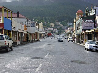
Orr Street, Queenstown is the main street of Queenstown, Tasmania, Australia.
Queenstown to Strahan road is a road that connects Queenstown with Strahan in Western Tasmania.
Zeehan-Strahan Road is a road that links Strahan with Zeehan in Western Tasmania.

The term Mount Lyell Railway was one of the terms used for the railway operated by the Mount Lyell Mining and Railway Company between 1899 and 1963.
This page is based on this
Wikipedia article Text is available under the
CC BY-SA 4.0 license; additional terms may apply.
Images, videos and audio are available under their respective licenses.
