West Coast Council is a local government body in Tasmania, covering much of the western region of the state. West Coast is classified as a rural local government area and has a population of 4,167. The major towns and localities of the region include Strahan, Rosebery, Zeehan and the principal town of Queenstown.

Zeehan is a town on the west coast of Tasmania, Australia 139 kilometres (86 mi) south-west of Burnie. It is part of the West Coast Council, along with the seaport Strahan and neighbouring mining towns of Rosebery and Queenstown.

The Lyell Highway is a highway in Tasmania, running from Hobart to Queenstown. It is the one of two transport routes that passes through the West Coast Range, the other being the Anthony Road.

The West Coast of Tasmania is mainly isolated rough country, associated with wilderness, mining and tourism. It served as the location of an early convict settlement in the early history of Van Diemen's Land, and contrasts sharply with the more developed and populous northern and eastern parts of the island state.
Regatta Point is the location of a port and rail terminus on Macquarie Harbour.
Trial Harbour is a rural locality in the local government area (LGA) of West Coast in the North-west and west LGA region of Tasmania. The locality is about 20 kilometres (12 mi) south-west of the town of Zeehan. The 2016 census has a population of 24 for the state suburb of Trial Harbour.
The Mount Jukes mine sites were a series of short-lived, small mine workings high on the upper regions of Mount Jukes in the West Coast Range on the West Coast of Tasmania.

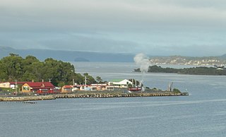
Strahan Airport is an airport located 2 nautical miles west of Strahan, Tasmania, Australia. It is the main airport for the West Coast of Tasmania, and is owned and maintained by the West Coast Council. The need for an airport in the area was suggested in the 1950s, and suggestions for upgrades have occurred over time.
Ocean Beach is a long stretch of beach running north of Macquarie Heads and Hells Gates on the West Coast of Tasmania. It is close to Strahan and parallel to the Strahan Airport runway. It extends as far north as Trial Harbour and the coast immediately west of Zeehan.
The mines of the West Coast of Tasmania have a rich historical heritage as well as an important mineralogical value in containing or having had found, specimens of rare and unusual minerals. Also, the various mining fields have important roles in the understanding of the mineralization of the Mount Read Volcanics, and the occurrence of economic minerals.
The history of the Railways on the West Coast of Tasmania has fascinated enthusiasts from around the world, because of the combination of the harsh terrain in which the railways were created, and the unique nature of most of the lines.
The Strahan–Zeehan Railway, also known as the "Government Railway", was a railway from Strahan to Zeehan on the west coast of Tasmania.
The Henty River is a perennial river in the West Coast region of Tasmania, Australia. The river generally lies north of Queenstown and south of Zeehan.

Zeehan railway station in Tasmania, was a major junction and railway yard for numerous different railway and tramway systems in western Tasmania in the town of Zeehan.

Philosophers Ridge is the long spur that connects Mount Lyell and Mount Owen in the West Coast Range of Western Tasmania.
Howard's Plains is a plain just west and above the river valley location of Queenstown in Western Tasmania, Australia. It is located to the east of the Henty River catchment area.
Orr Street, Queenstown is the main street of Queenstown, Tasmania, Australia.
Main Street, Zeehan is the main street of the Western Tasmanian town of Zeehan.
Zeehan Highway is a road between Zeehan and Queenstown in Western Tasmania.
Queenstown to Strahan road is a road that connects Queenstown with Strahan in Western Tasmania.