Henty River

Last updated

Henty River
Henty-River Tasmania.jpg
Henty River, Tasmania
Relief Map of Tasmania.png
Red pog.svg
Location of the Henty River mouth in Tasmania
Location
Country Australia
State Tasmania
Region West Coast
Physical characteristics
Source Tyndall Range, West Coast Range
Source confluenceDobson Creek and Newton Creek
  locationbelow Mount Tyndall
  coordinates 41°53′19″S145°32′43″E / 41.88861°S 145.54528°E / -41.88861; 145.54528
  elevation264 m (866 ft)
Mouth Southern Ocean
  location
Henty Dunes
  coordinates
42°2′44″S145°14′43″E / 42.04556°S 145.24528°E / -42.04556; 145.24528 Coordinates: 42°2′44″S145°14′43″E / 42.04556°S 145.24528°E / -42.04556; 145.24528
  elevation
0 m (0 ft)
Length46 km (29 mi)
Basin size1009834 sm
Basin features
Tributaries 
  left Yolande River, Lost Creek (Tasmania), Tully River (Tasmania)
  rightEwart Creek, Malcom Creek, Bottle Creek, McCutcheons Creek, Badger River
[1]

The Henty River is a perennial river in the West Coast region of Tasmania, Australia. The river generally lies north of Queenstown and south of Zeehan.

Contents

Location and features

Formed by the confluence of the Dobson and Newton Creeks, the river rises below Lake Newton on the western slopes of the Tyndall Range, northwest of Mount Tyndall, part of the West Coast Range of Tasmania.

The river flows generally south by west and then west, joined by eight tributaries.

Bottle Creek
Lost Creek
Malcolm Creek
McCutcheom's Creek
Tully
Yolande
Badger

The mouth emptying into the Southern Ocean at Henty Dunes.

The river descends 264 metres (866 ft) over its 46-kilometre (29 mi) course. [1]

In the area known as the Upper Henty at the river's headwaters is the Henty Gold Mine. [2] [3] Its upper reaches were some of the last sites of dam making by the Hydro Tasmania in its long history of regulating flow of Tasmanian rivers.[ citation needed ]

The river catchment has two areas of high ground. One is known as the Professor Plateau, west of the Professor Range to the north of the river, and the other Misery Flat, which is high ground between the Tully River and Lost Creek. [4]

The river basin is adjacent to the West Coast Range and the Lake Margaret areas, argued as having up to four separate periods of glaciation. [5]

The river is crossed by bridges that carry the Zeehan-Strahan Road and the Zeehan Highway. A former bridge that carried the Strahan-Zeehan Railway, very close to the coast and Ocean Beach, has since been demolished.

Recreation uses

During October and November, the Henty River is a location for sea run trout.

Picnic spots are available beside the river at either the Strahan to Zeehan highway, or the Zeehan Highway.

See also

Related Research Articles

Strahan, Tasmania Town in Tasmania, Australia

Strahan, is a small town and former port on the west coast of Tasmania. It is now a significant locality for tourism in the region.

Zeehan Town in Tasmania, Australia

Zeehan is a town on the west coast of Tasmania, Australia 139 kilometres (86 mi) south-west of Burnie. It is located north of Strahan, Tasmania and Queenstown, Tasmania.

West Coast Range Mountain range in Tasmania, Australia

The West Coast Range is a mountain range located in the West Coast region of Tasmania, Australia.

Lake Margaret (Tasmania) Dam in West Coast, Tasmania

Lake Margaret is a concrete-faced gravity dam with an uncontrolled spillway across the Yolande River, located on the north side of Mount Sedgwick, in the West Coast Range, West Coast of Tasmania, Australia.

West Coast, Tasmania

The West Coast of Tasmania is mainly isolated rough country, associated with wilderness, mining and tourism. It served as the location of an early convict settlement in the early history of Van Diemen's Land, and contrasts sharply with the more developed and populous northern and eastern parts of the island state.

Murchison Highway

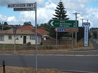
The Murchison Highway is a highway located in the West Coast region of Tasmania, Australia. The 147-kilometre (91 mi) highway runs generally north–south, with Somerset, near Burnie, as its northern terminus and Zeehan as its southern terminus. The highway was opened on 13 December 1963. Part of the highway from Waratah to Burnie was known as the Waratah Highway until 1973.

Trial Harbour Town in Tasmania, Australia

Trial Harbour is a rural locality in the local government area (LGA) of West Coast in the North-west and west LGA region of Tasmania. The locality is about 20 kilometres (12 mi) south-west of the town of Zeehan. The 2016 census has a population of 24 for the state suburb of Trial Harbour.

Linda Valley

Linda Valley is a valley in the West Coast Range of Tasmania. It was earlier known as the Vale of Chamouni. It is located between Mount Owen and Mount Lyell.

Mount Sedgwick (Tasmania)

Mount Sedgwick is a mountain located within the West Coast Range, in the West Coast region of Tasmania, Australia.

The mines of the West Coast of Tasmania have a rich historical heritage as well as an important mineralogical value in containing or having had found, specimens of rare and unusual minerals. Also, the various mining fields have important roles in the understanding of the mineralization of the Mount Read Volcanics, and the occurrence of economic minerals.

The Strahan–Zeehan Railway, also known as the 'Government Railway', was a railway from Strahan to Zeehan on the west coast of Tasmania.

Mount Tyndall (Tasmania)

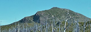
Mount Tyndall is a mountain that is part of the Tyndall Range, a spur off the West Coast Range, located in the Western region of Tasmania, Australia.

Geology of Tasmania

The geology of Tasmania is complex, with the world's biggest exposure of diabase, or dolerite. The rock record contains representatives of each period of the Neoproterozoic, Paleozoic, Mesozoic and Cenozoic eras. It is one of the few southern hemisphere areas that were glaciated during the Pleistocene with glacial landforms in the higher parts. The west coast region hosts significant mineralisation and numerous active and historic mines.

The Anthony Road is a major B Route in Western Tasmania, running from the Murchison Highway (A10) at Tullah to the Zeehan Highway (A10) north of Queenstown.

Tyndall Range

The Tyndall Range, commonly called The Tyndalls, is a mountain range that is part of the West Coast Range located in the Western region of Tasmania, Australia.
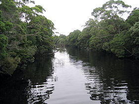
2016 Tasmanian bushfires

The 2016 Tasmanian Bushfires were a large series of bushfires in Tasmania which started in January 2016 throughout the state, and continued into February 2016, with considerable damage to fire sensitive areas in the Central Highlands, West Coast and South West regions. By autumn 2016, no bushfires were reported within the state.

Howard's Plains is a plain just west and above the river valley location of Queenstown in Western Tasmania, Australia. It is located to the east of the Henty River catchment area.

Zeehan Highway is a road between Zeehan and Queenstown in Western Tasmania.

Queenstown to Strahan road is a road that connects Queenstown with Strahan in Western Tasmania.

Zeehan-Strahan Road is a road that links Strahan with Zeehan in Western Tasmania.

References

  1. 1 2 "Map of Henty River, TAS". Bonzle Digital Atlas of Australia. Retrieved 26 June 2015.
  2. Taylor, R. J.; others (July 1985). "Mammals of the upper Henty River region, Western Tasmania". Papers and Proceedings of the Royal Society of Tasmania. 119 (July 1985): 7–14. Retrieved 9 June 2012.
  3. Taylor, R. J. (1986). Notes on the diet of the carnivorous mammals of the Upper Henty River Region, western Tasmania . Retrieved 9 June 2012.
  4. Identified in Tasmap 1:100,000 series maps of the area - 1987 edition example published in Binks, C. J. (1988), Pioneers of Tasmania's west coast, Blubber Head Press, ISBN   978-0-908528-16-5
  5. Augustinus, P. C.; Colhoun, E. A. (1995). Weathering and morphostratigraphic evidence for four glaciations in the Henty River Basin, western Tasmania . Retrieved 9 June 2012.

Further reading