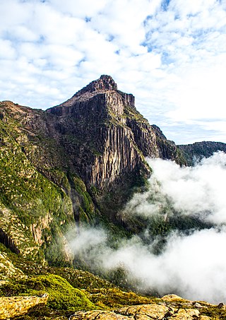
The Franklin River is a major perennial river located in the Central Highlands and western regions of Tasmania, Australia. The river is located in the Franklin-Gordon Wild Rivers National Park at the mid northern area of the Tasmanian Wilderness World Heritage Area. Its source is situated at the western edge of the Central Highlands and it flows west towards the West Coast.

The Franklin Dam or Gordon-below-Franklin Dam project was a proposed dam on the Gordon River in Tasmania, Australia, that was never constructed. The movement that eventually led to the project's cancellation became one of the most significant environmental campaigns in Australian history.

The Gordon River is a major perennial river located in the central highlands, south-west, and western regions of Tasmania, Australia.

Macquarie Harbour is a shallow fjord in the West Coast region of Tasmania, Australia. It is approximately 315 square kilometres (122 sq mi), and has an average depth of 15 metres (49 ft), with deeper places up to 50 metres (160 ft). It is navigable by shallow-draft vessels. The main channel is kept clear by the presence of a rock wall on the outside of the channel's curve. This man-made wall prevents erosion and keeps the channel deep and narrow, rather than allowing the channel to become wide and shallow. A reported Aboriginal name for the harbour is Parralaongatek.

Peter Dombrovskis was an Australian photographer, known for his Tasmanian scenes. In 2003, he was posthumously inducted into the International Photography Hall of Fame, the first Australian photographer to achieve that honour.
Olegas Truchanas was a Lithuanian-Australian conservationist and nature photographer.

The West Coast Range is a mountain range located in the West Coast region of Tasmania, Australia.

Evandale is an historic town in northern Tasmania, Australia. It sits on the banks of the South Esk River, 18 km south of Launceston. Named after early colonial explorer and Surveyor-General George Evans, the town is famous for its late-Georgian and early-Victorian buildings with relatively untouched streetscape, a popular Sunday market and as a host to the annual World Penny Farthing bicycle Championships. At the 2016 census, Evandale had a population of 1,345.

The South West Wilderness of Tasmania, Australia is a remote and inaccessible region of South West Tasmania containing unspoilt scenery, rugged peaks, wild rivers, unique flora and fauna, and a long and rugged coastline. Parts of the wilderness are more than 50 km from the nearest road, so the only access to the area is by foot, air or sea.

The Arthur Range is a mountain range in the South West Wilderness, located in south-west Tasmania, Australia. The range is broken into two main sections, the Western Arthurs and the Eastern Arthurs. Both sections of the range are popular overnight bushwalking destinations, generally in summer.

The Eldon Range is a mountain range located in the west coast region of Tasmania, Australia.
Teepookana was a short lived port, community and railway stopping place on the southern bank of the King River, in Western Tasmania.
The Mackintosh River, part of the Pieman River catchment, is a major perennial river located in the West Coast region of Tasmania, Australia. The river was named in November 1828 by Henry Hellyer, a surveyor of the Van Diemans Land Company, in honour of Sir James Mackintosh, son of John Mackintosh of Kyllachy, Inverness-shire

South West Tasmania is a region in Tasmania that has evoked curiosity as to its resources over the duration of European presence on the island.
The Gordon Splits is a notable section of gorges of the Gordon River, located in South West Tasmania, Australia. The once impassable gorges are situated on the lower Gordon River in the Franklin-Gordon Wild Rivers National Park, part of the Tasmanian Wilderness World Heritage Area. The splits has also been an important location of focus within the larger environmental campaign for wilderness preservation in South West Tasmania.
The Davey River is a perennial river located in the south-west region of Tasmania, Australia.
The Weld Valley is a valley located in southern Tasmania. It is an area of aboriginal cultural heritage and natural history within the Tasmanian Wilderness World Heritage Area. The valley stretches north-west of Huonville and is approximately 50 kilometres (31 mi) west of Hobart.
Engineer Range is a mountain range in Western Tasmania, Australia.
The Prince of Wales Range is a mountain range in the South West Wilderness, Tasmania, Australia. It is situated north and parallel to the Denison River. It lies to the west of Lake Gordon, and southeast of Frenchmans Cap.
Angela McGowan is an Australian archaeologist known for her work on Aboriginal and European heritage and culture in Tasmania, Australia. McGowan predominantly worked in Heard Island, off the coast of Antarctica and Tasmania.


