Angela McGowan

Last updated

Angela McGowan is an Australian archaeologist known for her work on Aboriginal and European heritage and culture in Tasmania, Australia. [1] McGowan predominantly worked in Heard Island, off the coast of Antarctica and Tasmania. [2] [3] [4] [5]

Contents

Cultural heritage archaeology and advocacy

McGowan has spent over thirty years working in Tasmania in the cultural heritage management sector. More specifically for Heritage Tasmania, the Parks and Wildlife Service, the Tasmanian Museum and Art Gallery and in private practice. She joined the executive committee of the International Council on Monuments and Sites (ICOMOS) in February 2010, having previously served on the Tasmanian Heritage Council and is also a member of the Australasian Society for Historical Archaeology, the National Trust of Australia (TAS) and Cultural Heritage Practitioners of Tasmania. [1]

She has spoken directly to the gaps in legislation regarding consultation, involvement, and representation of aboriginal communities. [6] Her paper titled “Background to Changing Cultural Heritage Legislation in Tasmania” clearly and methodically covers the National Parks and Wildlife Act of 1970, Aboriginal Relics Act of 1975, and the Forestry Act of 1920, to name a few, revealing the imbalance in representation on each committee. McGowan brings to our attention that out of the twelve members under the National Parks and Wildlife Act only one representative is allocated historic structures, history, and anthropology while others are natural science based, and out of five on the Aboriginal Relics Advisory Council one member was a representative of Aboriginal interests while the rest were academic. [7]

Select archaeological investigations of Tasmania

Risdon Cove (1978-1980)

Risdon Cove, Tasmania is historically recognized as the initial site of Hobart, the capital of Tasmania. [4] Risdon Cove was established as a military base of the New South Wales military forces in September 1803, in order to prevent French explorers and militant forces from gaining access to settlement on Tasmania. [8] This site is primarily remembered for the massacre of aboriginal people on 3 May 1804 by British forces. Risdon Cove was abandoned in July 1804. [4] [5]

Angela Gowan excavated the site of Risdon Cove. After the abandonment of the site, the area had remained in its pre-industrialized state when McGowan conducted the excavations. [4] McGowan discovered twenty-nine archaeological features on the site, but she determined there to be only six key features dating back to the initial settlement of 1803. Features made out of stone were the only ones structurally sound enough to last two hundred years. [4] The six key features are as follows: "the storehouse, the storekeeper's house, the Governor's new house, Mountgarrett's house, a hut platform, and an enclosed clearing". [4] Of the six items determined to be dated back to 1803, the storehouse, the Governor's new house, and the Mountgarett's house provide the most information on the building patterns and culture of the first settlement. [5]

The storehouse was an essential part of the initial settlement, because it displayed an intention of residing on the settlement for an extended amount of time. [4] The Governor's new house, due to the high status of Lieutenant John Bowen, was intended to be the "largest and most dominant building of the settlement." [4] McGowan's excavation revealed the house to have never been completed. In terms of the Mountgarett's house, McGowan determined the house to be built for the naval surgeon, and it was the first residential building to have been built on the settlement. [4] [5]

Denison River Valley (1989)

This was a long-term study done into human activity during the late Pleistocene era in the Denison River Valley. McGowan, along with a team of other archaeologists, was able to find 23 different rock shelters across the valley. In order to determine if humans had once lived in these rock shelters, the team would look on the walls for paintings and the floors for artifacts. If nothing was discovered then they would create speed pits, which are holes dug into the ground that are less than 15 cm wide. Six of these rock shelters, as well as one location in the open, showed evidence of human activity. Two of these sites were excavated in detail to determine the extent of human activity. In total from all of these sites, they found 218 artifacts that are greater than 0.5 cm in size. This provided extensive information about stone artifact technology and how it related to human activity throughout the late Pleistocene era. [9] [2]

Survey of Sealing Sites on Heard Island (1986-1987)

One excavation that Angela McGowan has worked on are the sealer sites on Heard Island. She worked on this site in 1986 and 1987. The main reason that she wanted to shine a spotlight here is because the archaeological information at this site is being threatened by the wildlife and erosion of the coastline. This site gives a very unique perspective into the lives of European sealers in the 19th century, and so she wanted to save all of this information. She excavated the sites that were the most damaged sites first so that they could get the most data as possible. [10] [3] [11]

Kerry Lodge Convict site (2015-2018)

The Kerry Lodge Convict project [12] is located near Laucenston, Tasmania and is the site of a 19th-century British penal colony. McGowan was part of a small team made up of archaeologists, surveyors, and curators who invested time uncovering details of the relatively unknown site, their interests lay in the archaeology of incarceration and unfree labor. [13] The main focus of the project is to excavate and analyze the "remains of a collapsed stone structure associated with the convict probation station." [12]

Further publications

Related Research Articles

<span class="mw-page-title-main">Tasmania</span> State of Australia

Tasmania is an island state of Australia. It is located 240 kilometres (150 miles) to the south of the Australian mainland, separated from it by the Bass Strait, with the archipelago containing the southernmost point of the country. The state encompasses the main island of Tasmania, the 26th-largest island in the world, and the surrounding 1000 islands. It is Australia's least populous state, with 569,825 residents as of December 2021. The state capital and largest city is Hobart, with around 40 percent of the population living in the Greater Hobart area. This makes it Australia's most decentralised state.

This article describes the history of the Australian colony and state of Victoria.

<span class="mw-page-title-main">Aboriginal Tasmanians</span> Indigenous people of the Australian island state of Tasmania

The Aboriginal Tasmanians are the Aboriginal people of the Australian island of Tasmania, located south of the mainland. For much of the 20th century, the Tasmanian Aboriginal people were widely, and erroneously, thought of as being an extinct cultural and ethnic group that had been intentionally exterminated by white settlers. Contemporary figures (2016) for the number of people of Tasmanian Aboriginal descent vary according to the criteria used to determine this identity, ranging from 6,000 to over 23,000.

<span class="mw-page-title-main">Port Arthur, Tasmania</span> UNESCO World Heritage Site

Port Arthur is a town and former convict settlement on the Tasman Peninsula, in Tasmania, Australia. It is located approximately 97 kilometres (60 mi) southeast of the state capital, Hobart.

The history of Tasmania begins at the end of the Last Glacial Period when it is believed that the island was joined to the Australian mainland. Little is known of the human history of the island until the British colonisation of Tasmania in the 19th century.

<span class="mw-page-title-main">Risdon Cove</span> Cove near Hobart, Tasmania, Australia

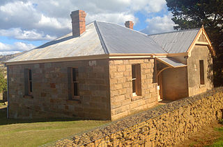
Risdon Cove is a cove located on the east bank of the Derwent River, approximately 7 kilometres (4 mi) north of Hobart, Tasmania. It was the site of the first British settlement in Van Diemen's Land, now Tasmania, the island state of Australia. The cove was named by John Hayes, who mapped the river in the ship Duke of Clarence in 1794, after his second officer William Bellamy Risdon.

<span class="mw-page-title-main">Wynyard, Tasmania</span> Town in Tasmania, Australia

Wynyard (/ˈwɪnjɚd/) wi-nyuhd) is a rural town located on the North West coast of Tasmania, Australia. Wynyard is situated 17 kilometres (11 mi) west of Burnie. As of the 2021 census, Wynyard has an estimated population of 6,296 The town is a regional hub servicing the surrounding rural areas, the adjacent Burnie Wynyard Airport provides commercial flights to Melbourne and other districts. The main council offices for the Waratah-Wynyard local government area are located in Wynyard.

<span class="mw-page-title-main">Macquarie Harbour Penal Station</span> Former convict colony on Sarah Island, Tasmania

The Macquarie Harbour Penal Station, a former British colonial penal settlement, established on Sarah Island, Macquarie Harbour, in the former colony of Van Diemen's Land, now Tasmania, operated between 1822 and 1833. The settlement housed male convicts, with a small number of women housed on a nearby island. During its 11 years of operation, the penal colony achieved a reputation as one of the harshest penal settlements in the Australian colonies. The formal penal station is located on the eight-hectare (twenty-acre) Sarah Island that now operates as an historic site under the direction of the Tasmania Parks and Wildlife Service.

<span class="mw-page-title-main">Maria Island</span> Island off the eastern Tasmanian coast

Maria Island or 'wukaluwikiwayna' in [palawa kani) is a mountainous island located in the Tasman Sea, off the east coast of Tasmania, Australia. The 115.5-square-kilometre (44.6 sq mi) island is contained within the Maria Island National Park, which includes a marine area of 18.78 square kilometres (7.25 sq mi) off the island's northwest coast. The island is about 20 kilometres (12 mi) in length from north to south and, at its widest, is about 13 kilometres (8.1 mi) west to east. At its closest point, Point Lesueur, the island lies approximately 4 kilometres (2.5 mi) off the east coast of Tasmania.

<span class="mw-page-title-main">Ben Lomond (Tasmania)</span> Mountain in the north of Tasmania

Ben Lomond is a mountain in the north-east of Tasmania, Australia.

<span class="mw-page-title-main">Clarke Island (Tasmania)</span> Island in Tasmania, Australia

The Clarke Island, part of the Furneaux Group, is an 82-square-kilometre (32 sq mi) island in Bass Strait, south of Cape Barren Island, about 24 kilometres (15 mi) off the northeast coast of Tasmania, Australia. Banks Strait separates the island from Cape Portland on the mainland.

The modern history of the Australian city of Hobart in Tasmania dates to its foundation as a British colony in 1804. Prior to British settlement, the area had been occupied for at least 8,000 years, but possibly for as long as 35,000 years, by the semi-nomadic Mouheneener tribe, a sub-group of the Nuenonne, or South-East tribe. The descendants of the indigenous Tasmanians now refer to themselves as 'Palawa'.

The following lists events that happened during 1804 in Australia.

Atlas Cove is a cove on the north coast of Heard Island and McDonald Islands in the southern Indian Ocean, and is entered between the base of the Laurens Peninsula and Rogers Head.

<span class="mw-page-title-main">Ross Female Factory</span> Former Australian workhouse for female convicts

The Ross Female Factory, a former Australian workhouse for female convicts in the penal colony of Van Diemen's Land, is located in the village of Ross, in the midlands region of Tasmania. Operational between 1848 and 1854, the factory is now one of the 11 sites that collectively comprise the Australian Convict Sites, listed on the World Heritage List by UNESCO.

<span class="mw-page-title-main">Jordan River (Tasmania)</span> River in Tasmania, Australia

The Jordan River is a perennial river located in the Midlands region of Tasmania, Australia.

Don Ranson is an Australian archaeologist who played an important role in the discovery and recognition of the antiquity of Aboriginal archaeology in Tasmania. This discovery has been documented in many subsequent histories of Tasmanian Archaeology, including that dedicated to the expedition itself, as well as video documentaries of the find.

Denison River is a river in South West Tasmania, Australia. It is within the South West Wilderness, and drains into the Gordon River below the Gordon Splits. Its catchment starts in the south of the King William Range.

East Risdon State Reserve is an IUCN Category II protected area on the eastern shore of the Derwent River in Clarence City, Hobart, Tasmania. It takes its name from the nearby suburb of Risdon.

Woretemoeteryenner, also known as "Bung", "Pung", and "Margaret", was an Aboriginal Tasmanian woman who had children with George Briggs, an English convict. She worked as a sealer and kangaroo hunter. Woretemoeteryenner and her sisters are among the few Palawa people whose lives bridge the experience of Aboriginal people before and after European contact.

References

  1. 1 2 "Angela McGowan". australia.icomos.org. 21 April 2010. Retrieved 24 January 2019.
  2. 1 2 "Front Matter". Australian Archaeology. 73 (73). December 2011. JSTOR   41485605.
  3. 1 2 McGowan, Lazer, Angela, Estelle (1988). Survey of Sealing Sites on Heard Island, 1986-1987. Angela McGowan and Estelle Lazer.
  4. 1 2 3 4 5 6 7 8 9 Graham, Connah (1993). The archaeology of Australia's history. Cambridge [England]: Cambridge University Press. ISBN   978-0521454759. OCLC   28410454.
  5. 1 2 3 4 McGowan, Angela (1985). Archaeological Investigations at Risdon Cove Historic Site: 1978-1980. Sandy Bay, Tasmania: Tasmania National Parks and Wildlife Service.
  6. Ross, Williams, Free, Anne, Michael John, Steve (1996). "The Repatriation Debate at the 1995 Conference of the Australian Archaeology Association". WAC News. OCLC   902783657.{{cite news}}: CS1 maint: multiple names: authors list (link)
  7. McGowan, Angela (1990). "Background to Changing Cultural Heritage Legislation in Tasmania". Australian Archaeology. 31: 61–66. doi:10.1080/03122417.1990.11681389.
  8. Ryan, Lyndall (2004). "Risdon Cove and the Massacre of 3 May 1804: Their Place in Tasmanian History". Mercury.
  9. Brown, Steve; Kee, Sue; McGowan, Angela; Middleton, Greg; Nash, Mike; Prince, Brian; Ricketts, Nigel; West, Darrell (1991). "A Preliminary Survey for Aboriginal Sites in the Denison River Valley March 1989". Australian Archaeology. 32 (32): 26–37. doi:10.1080/03122417.1991.11681408. JSTOR   40287029.
  10. McGowan, Angela (2000). "On Their Own: Towards an Analysis of Sealers' Sites on Heard Island" (PDF). Papers and Proceedings of the Royal Society of Tasmania. 133.
  11. Lazar, McGowan, Estelle, Angela (1987). Guidelines for the Conservation of Historic ANARE and Sealing Remains at Atlas Cove, Heard Island: A Report to the Antarctic Division, Department of Science. Australia: Australian National Antarctic Research Expeditions.
  12. 1 2 "Kerry Lodge Convict Site". Kerry Lodge Convict Site.
  13. "Uncovering Convict History at Kerry Lodge". heritage.tas.gov.au.