
Southwest National Park is an Australian national park located in the south-west of Tasmania, bounded by the Franklin-Gordon Wild Rivers National Park to the north and the Hartz Mountains National Park to the east. It is a part of a chain of national parks and state reserves that make up the Tasmanian Wilderness World Heritage Area. Covering an area of 6,183 km2 (2,387 sq mi), it is Tasmania's largest national park.

Lake Pedder, once a glacial outwash lake, is a man-made impoundment and diversion lake located in South West Tasmania, Australia. In addition to its natural catchment from the Frankland Range, the lake is formed by the 1972 damming of the Serpentine and Huon rivers by the Hydro-Electric Commission for the purpose of hydroelectric power generation. Consequently, the lake is also known, somewhat derisively, as the Huon-Serpentine Impoundment.

Lake Gordon is a man-made reservoir created by the Gordon Dam, located on the upper reaches of the Gordon River in the south-west region of Tasmania, Australia.
Strathgordon is a rural locality in the local government area (LGA) of Derwent Valley in the South-east LGA region of Tasmania. The locality is about 121 kilometres (75 mi) west of the town of New Norfolk. The 2016 census recorded a population of 15 for the state suburb of Southwest, which includes Strathgordon. It is on the road to the Gordon River Dam the most south westerly road in the south west of Tasmania. It is a tourist destination for visitors wishing to visit the Southwest National Park and World Heritage listed wilderness.

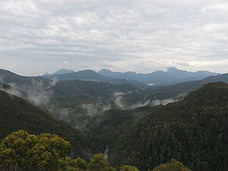
The South West Wilderness of Tasmania, Australia is a remote and inaccessible region of South West Tasmania containing unspoilt scenery, rugged peaks, wild rivers, unique flora and fauna, and a long and rugged coastline. Parts of the wilderness are more than 50 km from the nearest road, so the only access to the area is by foot, air or sea.

The Arthur Range is a mountain range in the South West Wilderness, located in south-west Tasmania, Australia. The range is broken into two main sections, the Western Arthurs and the Eastern Arthurs. Both sections of the range are popular overnight bushwalking destinations, generally in summer.
South West Tasmania is a region in Tasmania that has evoked curiosity and wonder during the period of European presence on the island.

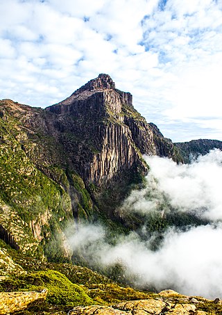
Mount Anne is a mountain located in the Southwest National Park in south-west region of Tasmania, Australia. The mountain lies within the UNESCO World Heritage-listed Tasmanian Wilderness.
The Gordon River Road, sometimes called the Strathgordon Road, (B61), is a road in the south western region of Tasmania, Australia.
The Gordon Dam, also known as the Gordon River Dam, is a major gated double curvature concrete arch dam with a controlled spillway across the Gordon River, located in Southwest National Park, Tasmania, Australia. The impounded reservoir is called Lake Gordon.
The Scotts Peak Dam Road is the most southerly point of road access into Southwest National Park, Tasmania, Australia.
The Scotts Peak Dam is a rockfill embankment dam without a spillway across the Huon River, located in the South West region of Tasmania, Australia.
The Serpentine Dam is a rockfill embankment dam with a concrete face and a controlled spillway across the Serpentine River, located in the South West region of Tasmania, Australia.
The Edgar Dam is an earthfill embankment saddle dam without a spillway, located offstream in the South West region of Tasmania, Australia.
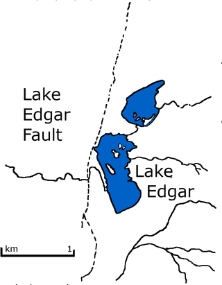
Lake Edgar was a natural fault scarp pond on the upper reaches of the Huon River in South West Tasmania.

The Frankland Range is a mountain range that is located in the south-west region of Tasmania, Australia. The range forms part of a natural south-western border to the impounded Lake Pedder, formed by the damming of the Serpentine and Huon rivers.
Brenda Hean (1910-1972) was a member of the Lake Pedder Action Committee (LPAC) and a resident of Hobart, Tasmania who disappeared at the time of the flooding of Lake Pedder.
The Lake Pedder Action Committee was a Tasmanian environmental group.
The Port Davey Track, officially the Old Port Davey Track, is a bushwalking track located in the south western region of Tasmania, Australia. The 70-kilometre (43 mi) track traverses remote wilderness within the Southwest National Park, part of the Tasmanian Wilderness World Heritage Site, and is managed as a wilderness walk. The Tasmanian Parks & Wildlife Service recommend that experienced bushwalkers can take four-to-five days to cover the track in one direction.
This page discusses the rivers and hydrography of the state of Tasmania, Australia.
