
The River Derwent, also known as timtumili minanya in palawa kani, is a significant river and tidal estuary in Tasmania, Australia. It begins its journey as a freshwater river in the Central Highlands at Lake St Clair, descending over 700 metres (2,300 ft) across a distance of more than 200 kilometres (120 mi). At the settlement of New Norfolk in the Derwent Valley its waters become brackish, flowing through Hobart, the capital city of Tasmania, its seawater estuary eventually empties into Storm Bay and the Tasman Sea.

Lake Pedder, once a glacial outwash lake, is a man-made impoundment and diversion lake located in the southwest of Tasmania, Australia. In addition to its natural catchment from the Frankland Range, the lake is formed by the 1972 damming of the Serpentine and Huon rivers by the Hydro Electric Commission of Tasmania for the purposes of hydroelectric power generation.

The Gordon River is a major perennial river located in the central highlands, south-west, and western regions of Tasmania, Australia.

Hydro Tasmania, known for most of its history as the Hydro-Electric Commission (HEC) or The Hydro, is the trading name of the Hydro-Electric Corporation, a Tasmanian Government business enterprise which is the predominant electricity generator in the state of Tasmania, Australia. The Hydro was originally oriented towards hydro-electricity, due to Tasmania's dramatic topography and relatively high rainfall in the central and western parts of the state. Today Hydro Tasmania operates thirty hydro-electric and one gas power station, and is a joint owner in three wind farms.
The Great Lake, officially yingina / Great Lake, is a natural lake and man-made reservoir that is located in the central northern region of Tasmania, Australia.
Strathgordon is a rural locality in the local government area (LGA) of Derwent Valley in the South-east LGA region of Tasmania. The locality is about 121 kilometres (75 mi) west of the town of New Norfolk. The 2016 census recorded a population of 15 for the state suburb of Southwest, which includes Strathgordon. It is on the road to the Gordon River dam the most south westerly road in the south west of Tasmania. It is a tourist destination for visitors wishing to visit the Southwest National Park and World Heritage listed wilderness.
Lake Margaret is a concrete-faced gravity dam with an uncontrolled spillway across the Yolande River, located on the north side of Mount Sedgwick, in the West Coast Range, West Coast of Tasmania, Australia.

Lake Burbury is a man-made water reservoir created by the Crotty Dam inundating the upper King River valley that lies east of the West Coast Range. Discharge from the reservoir feeds the John Butters Hydroelectric Power Station, owned and operated by Hydro Tasmania.
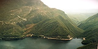
The Crotty Dam, also known during construction as the King Dam, or the King River Dam on initial approval, is a rockfill embankment dam with a controlled and uncontrolled spillway across the King River, between Mount Jukes and Mount Huxley, located in Western Tasmania, Australia.

The Gordon Power Station is the largest conventional hydroelectric power station in Tasmania, Australia; located in the South West region of the state. The power station is situated on Gordon River. Water from Lake Gordon descends 183 metres (600 ft) underground past the Gordon Dam and into the power station.
The Gordon Dam, also known as the Gordon River Dam, is a major gated double curvature concrete arch dam with a controlled spillway across the Gordon River, located in Southwest National Park, Tasmania, Australia. The impounded reservoir is called Lake Gordon.
The Scotts Peak Dam is a rockfill embankment dam without a spillway across the Huon River, located in the South West region of Tasmania, Australia.
The Serpentine Dam is a rockfill embankment dam with a concrete face and a controlled spillway across the Serpentine River, located in the South West region of Tasmania, Australia.
The Edgar Dam is an earthfill embankment saddle dam without a spillway, located offstream in the South West region of Tasmania, Australia.
The Anthony Power Development Scheme, part of the Pieman River power development scheme, was a proposed scheme for damming parts of the upper catchment of the Pieman River in Western Tasmania, Australia.
The Lake Pedder Action Committee was a Tasmanian environmental group.
The Arthurs Lake is a man-made reservoir located in the Central Highlands region of Tasmania, Australia. The lake was created in the 1920s by the Hydro-Electric Commission of Tasmania damming the Upper Lake River, Blue Lake and Sand Lake as well as the Morass Marsh. The principal purpose of the lake is to support the generation of hydroelectricity.
Pieman River Power Development was a major 1970s and 1980s hydroelectric development of the Pieman River and its tributaries on the west coast of Tasmania.
The 2016 Tasmanian energy crisis was an ongoing energy storage situation in the state of Tasmania, Australia in 2016. Two years of high volumes of energy exported to Victoria via the Basslink HVDC cable, followed by low rainfall, and a fault which rendered the cable inoperable, resulted in record low storage levels in Tasmania's hydro-electric system. This resulted in a number of contingency plans to be enacted by Hydro Tasmania and the Hodgman Government.
Tasmania, as an advanced economy with a globally high standard of living, uses a great deal of energy. Distinctive features of energy use in Tasmania include the high fraction of hydroelectricity usage, the absence of coal-fired electrical generation, relatively light usage of natural gas, particularly for domestic use, and a wide use of domestic wood-burning stoves. Energy production through hydroelectricity has been politically contentious, and conflicts over Tasmanian hydroelectric projects were integral to the formation of Green parties in Australia and across the world.


