
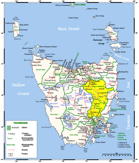
Tasmania is an island state of Australia. It is located 240 km (150 mi) to the south of the Australian mainland, separated by Bass Strait. The state encompasses the main island of Tasmania, the 26th-largest island in the world, and the surrounding 1000 islands. The state has a population of about 541,000 people as of September 2020. The state capital and largest city is Hobart, with around 40 percent of the population living in the Greater Hobart area.
Protected areas of Tasmania consist of protected areas located within Tasmania and its immediate onshore waters, including Macquarie Island. It includes areas of crown land managed by Tasmanian Government agencies as well as private reserves. As of 2016, 52% of Tasmania's land area has some form of reservation classification, the majority is managed by the Tasmania Parks & Wildlife Service. Marine protected areas cover about 7.9% of state waters.

The Aboriginal Tasmanians are the Aboriginal people of the Australian island of Tasmania, located south of the mainland. For much of the 20th century, the Tasmanian Aboriginal people were widely, and erroneously, thought of as being an extinct cultural and ethnic group that had been intentionally exterminated by white settlers. Contemporary figures (2016) for the number of people of Tasmanian Aboriginal descent vary according to the criteria used to determine this identity, ranging from 6,000 to over 23,000.

Longford is a town in the northern midlands of Tasmania, Australia. It lies 145 m above sea level at the convergence of the Macquarie River and the South Esk River, 21 km south of Launceston and a 15-minute drive from the airport. It is just south of the Illawarra Road, a road connecting the Bass and Midland Highways. It has a population of 3,863 and is part of the Northern Midlands Council area. The region is predominantly agricultural, noted for wool, dairy produce and stock breeding.
The Midlands is a region of Tasmania between Launceston and Hobart. It also refers to the relatively flat, dry agricultural area, so named because it covers the region between the two cities. Its name is probably also influenced from the Midlands in the United Kingdom. It lends its name to the Southern Midlands Council, Northern Midlands Council, and the Midland Highway. The region is sometimes conflated or confused with the adjacent region of the Central Highlands—with the added term Tasmania's heartland.

The Great Lake is a natural lake and man-made reservoir that is located in the central northern region of Tasmania, Australia.

Diabase or dolerite or microgabbro is a mafic, holocrystalline, subvolcanic rock equivalent to volcanic basalt or plutonic gabbro. Diabase dikes and sills are typically shallow intrusive bodies and often exhibit fine grained to aphanitic chilled margins which may contain tachylite. Diabase is the preferred name in North America, while dolerite is the preferred name in the rest of the English-speaking world, where sometimes the name diabase is applied to altered dolerites and basalts. Some geologists prefer the name microgabbro to avoid this confusion.
Lake Barlee is an intermittent salt lake. With a surface area of 1,980 square kilometres (764 sq mi), it is the second largest lake in Western Australia.

Oatlands is an important historical village on the shores of Lake Dulverton in the centre of Tasmania, Australia. Oatlands is located 84 km north of Hobart and 115 km south of Launceston on the Midland Highway. At the 2016 census, Oatlands had a population of 683.

The Lyell Highway is a highway in Tasmania, running from Hobart to Queenstown. It is the one of two transport routes that passes through the West Coast Range, the other being the Anthony Road.
The Central Highlands is a region in Tasmania, Australia where geographical and administrative boundaries closely coincide. It is also known as The Lake Country of Tasmania.

Pedra Branca is a rock islet or small island, located in the Southern Ocean, off the southern coast of Tasmania, Australia. The island is situated approximately 26 kilometres (16 mi) south southeast of South East Cape and is contained within the Southwest National Park, part of the Tasmanian Wilderness World Heritage Site. An erosional remnant of the Tasmanian mainland, the island is approximately 270 metres (890 ft) long, 100 metres (330 ft) wide, with an elevation of 60 metres (200 ft) above sea level. The island is estimated to have separated from the Tasmanian mainland at least 15,000 years ago.

Ross is a historic town in the Midlands of the state of Tasmania in Australia. On the Macquarie River, Ross is located 78 km south of Launceston and 117 km north of Hobart. The town is listed on the Register of the National Estate and is noted for its historic bridge, original sandstone buildings and convict history.

Quamby Bluff is a mountain in Northern Tasmania, Australia that is an outlying part of the Great Western Tiers mountain range.

The geology of Tasmania is complex, with the world's biggest exposure of diabase, or dolerite. The rock record contains representatives of each period of the Neoproterozoic, Paleozoic, Mesozoic and Cenozoic eras. It is one of the few southern hemisphere areas that were glaciated during the Pleistocene with glacial landforms in the higher parts. The west coast region hosts significant mineralisation and numerous active and historic mines.

Lake Edgar was a natural fault scarp pond on the upper reaches of the Huon River in South West Tasmania.

Lake Hindmarsh, a eutrophic lake located in the Wimmera region of western Victoria, Australia, is the state's largest natural freshwater lake. The nearest towns are Jeparit to the south and Rainbow to the north. After more than a decade of drought, in early 2011 the lake filled as a result of flooding in the region. The Wemba Wemba name for the lake is recorded as Gour or Koor.

Lavinia State Reserve, formerly Lavinia Nature Reserve, is a 68 km2 protected area on King Island, lying at the western end of Bass Strait and belonging to the Australian state of Tasmania.
