
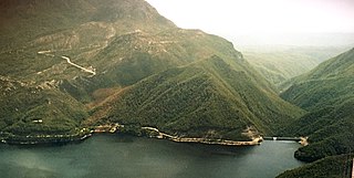
Lake Pedder, once a glacial outwash lake, is a man-made impoundment and diversion lake located in the southwest of Tasmania, Australia. In addition to its natural catchment from the Frankland Range, the lake is formed by the 1972 damming of the Serpentine and Huon rivers by the Hydro Electric Commission of Tasmania for the purposes of hydroelectric power generation.

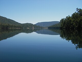
Lake Gordon is a man-made reservoir created by the Gordon Dam, located on the upper reaches of the Gordon River in the south-west region of Tasmania, Australia.

The Gordon River is a major perennial river located in the central highlands, south-west, and western regions of Tasmania, Australia.
The purple sulfur bacteria (PSB) are part of a group of Pseudomonadota capable of photosynthesis, collectively referred to as purple bacteria. They are anaerobic or microaerophilic, and are often found in stratified water environments including hot springs, stagnant water bodies, as well as microbial mats in intertidal zones. Unlike plants, algae, and cyanobacteria, purple sulfur bacteria do not use water as their reducing agent, and therefore do not produce oxygen. Instead, they can use sulfur in the form of sulfide, or thiosulfate (as well, some species can use H2, Fe2+, or NO2−) as the electron donor in their photosynthetic pathways. The sulfur is oxidized to produce granules of elemental sulfur. This, in turn, may be oxidized to form sulfuric acid.

The Snowy River is a major river in south-eastern Australia. It originates on the slopes of Mount Kosciuszko, Australia's highest mainland peak, draining the eastern slopes of the Snowy Mountains in New South Wales, before flowing through the Alpine National Park and the Snowy River National Park in Victoria and emptying into Bass Strait.
Hydro Tasmania, known for most of its history as the Hydro-Electric Commission (HEC) or The Hydro, is the trading name of the Hydro-Electric Corporation, a Tasmanian Government business enterprise which is the predominant electricity generator in the state of Tasmania, Australia. The Hydro was originally oriented towards hydro-electricity, due to Tasmania's dramatic topography and relatively high rainfall in the central and western parts of the state. Today Hydro Tasmania operates thirty hydro-electric and one gas power station, and is a joint owner in three wind farms.

A meromictic lake is a lake which has layers of water that do not intermix. In ordinary, holomictic lakes, at least once each year, there is a physical mixing of the surface and the deep waters.
The Crotty Dam, also known during construction as the King Dam, or the King River Dam on initial approval, is a rockfill embankment dam with a controlled and uncontrolled spillway across the King River, between Mount Jukes and Mount Huxley, located in Western Tasmania, Australia.

The Wivenhoe Dam is a rock and earth-fill embankment dam with a concrete spillway across the Brisbane River in South East Queensland, Australia. The dam takes it names from the local Wivenhoe Pocket rural community. The dam wall is located about 80 kilometres (50 mi) by road from the centre of Brisbane. The primary purpose of the dam is the supply of potable water for the Brisbane and Ipswich regions. The dam also provides for flood mitigation control, hydroelectricity, and recreation. The impounded reservoir is called Lake Wivenhoe and the dam, the lake and a narrow strip of surrounding land forms a locality also called Lake Wivenhoe.
Øvrevatnet or Øvervatnet is a meromictic lake that lies in, Fauske Municipality in Nordland county, Norway. The lake lies about 6 km (3.7 mi) east of the town of Fauske. It's waters is fresh just down to 10–15 m (33–49 ft). From that level the water is getting more salty. Øvrevatnet is also much polluted from earlier times mining industry upstream. The 11-square-kilometre (4.2 sq mi) lake flows out into the neighboring lake Nedrevatnet to the west.
The William Hovell Dam is a rock and earth-fill embankment dam with a flip bucket chute spillway across the King River, operated by Pacific Blue and located in the Hume region of Victoria, Australia. The purposes of the dam are for irrigation and the generation of hydroelectricity. The impounded reservoir is called Lake William Hovell.

The Gordon Power Station is the largest conventional hydroelectric power station in Tasmania, Australia; located in the South West region of the state. The power station is situated on Gordon River. Water from Lake Gordon descends 183 metres (600 ft) underground past the Gordon Dam and into the power station.
The Gordon Dam, also known as the Gordon River Dam, is a major gated double curvature concrete arch dam with a controlled spillway across the Gordon River, located in Southwest National Park, Tasmania, Australia. The impounded reservoir is called Lake Gordon.
The Scotts Peak Dam is a rockfill embankment dam without a spillway across the Huon River, located in the South West region of Tasmania, Australia.
The Serpentine Dam is a rockfill embankment dam with a concrete face and a controlled spillway across the Serpentine River, located in the South West region of Tasmania, Australia.
The Edgar Dam is an earthfill embankment saddle dam without a spillway, located offstream in the South West region of Tasmania, Australia.

The Glenmaggie Dam is a concrete block-foundation gravity dam with 14 radial arm gates across the Macalister River, located near Maffra, Central Gippsland, in the Australian state of Victoria. The dam's purpose includes irrigation, the generation of hydro-electric power, water supply and conservation. The impounded reservoir is called Lake Glenmaggie.
Euxinia or euxinic conditions occur when water is both anoxic and sulfidic. This means that there is no oxygen (O2) and a raised level of free hydrogen sulfide (H2S). Euxinic bodies of water are frequently strongly stratified; have an oxic, highly productive, thin surface layer; and have anoxic, sulfidic bottom water. The word "euxinia" is derived from the Greek name for the Black Sea (Εὔξεινος Πόντος (Euxeinos Pontos)) which translates to "hospitable sea". Euxinic deep water is a key component of the Canfield ocean, a model of oceans during part of the Proterozoic eon (a part specifically known as the Boring Billion) proposed by Donald Canfield, an American geologist, in 1998. There is still debate within the scientific community on both the duration and frequency of euxinic conditions in the ancient oceans. Euxinia is relatively rare in modern bodies of water, but does still happen in places like the Black Sea and certain fjords.

Brownie Lake is a lake in Hennepin County, Minnesota, and within the city limits of Minneapolis. It is the northernmost lake in the Minneapolis Chain of Lakes. It is within Brownie Lake Park, and administered by the Minneapolis Park and Recreation Board (MPRB).
