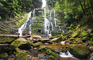
Franklin-Gordon Wild Rivers is a national park in Tasmania, 117 km west of Hobart. It is named after the two main river systems lying within the bounds of the park - the Franklin River and the Gordon River.

The Franklin River is a major perennial river located in the Central Highlands and western regions of Tasmania, Australia. The river is located in the Franklin-Gordon Wild Rivers National Park at the mid northern area of the Tasmanian Wilderness World Heritage Area. Its source is situated at the western edge of the Central Highlands and it flows west towards the West Coast.

Lake Pedder, once a glacial outwash lake, is a man-made impoundment and diversion lake located in the southwest of Tasmania, Australia. In addition to its natural catchment from the Frankland Range, the lake is formed by the 1972 damming of the Serpentine and Huon rivers by the Hydro Electric Commission of Tasmania for the purposes of hydroelectric power generation.

The Franklin Dam or Gordon-below-Franklin Dam project was a proposed dam on the Gordon River in Tasmania, Australia, that was never constructed. The movement that eventually led to the project's cancellation became one of the most significant environmental campaigns in Australian history.

Lake Gordon is a man-made reservoir created by the Gordon Dam, located on the upper reaches of the Gordon River in the south-west region of Tasmania, Australia.

Strahan, is a small town and former port on the west coast of Tasmania. It is now a significant locality for tourism in the region.

Macquarie Harbour is a shallow fjord in the West Coast region of Tasmania, Australia. It is approximately 315 square kilometres (122 sq mi), and has an average depth of 15 metres (49 ft), with deeper places up to 50 metres (160 ft). It is navigable by shallow-draft vessels. The main channel is kept clear by the presence of a rock wall on the outside of the channel's curve. This man-made wall prevents erosion and keeps the channel deep and narrow, rather than allowing the channel to become wide and shallow. A reported Aboriginal name for the harbour is Parralaongatek.
The King River is a major perennial river in the West Coast region of Tasmania, Australia.

Peter Dombrovskis was an Australian photographer, known for his Tasmanian scenes. In 2003, he was posthumously inducted into the International Photography Hall of Fame, the first Australian photographer to achieve that honour.
Hydro Tasmania, known for most of its history as the Hydro-Electric Commission (HEC) or The Hydro, is the trading name of the Hydro-Electric Corporation, a Tasmanian Government business enterprise which is the predominant electricity generator in the state of Tasmania, Australia. The Hydro was originally oriented towards hydro-electricity, due to Tasmania's dramatic topography and relatively high rainfall in the central and western parts of the state. Today Hydro Tasmania operates thirty hydro-electric and one gas power station, and is a joint owner in three wind farms.
Olegas Truchanas was a Lithuanian-Australian conservationist and nature photographer.
Lake Fidler is a meromictic lake beside the Gordon River in the Tasmanian Wilderness World Heritage Site area of the west coast of Tasmania, Australia. The lake has a layer of fresh water overlying an anoxic salt water layer. The meromictic lakes and ponds of the Gordon River were discovered by D. A. Hodgson and Professor Peter Tyler.

The West Coast of Tasmania is mainly isolated rough country, associated with wilderness, mining and tourism. It served as the location of an early convict settlement in the early history of Van Diemen's Land, and contrasts sharply with the more developed and populous northern and eastern parts of the island state.
The Tasmanian Wilderness Society was a Tasmanian environmental group that started in 1976 in response to a proposal by the state's Hydro Electric Commission to construct a dam on the Gordon River, downstream from the Franklin River, that led to the Franklin Dam controversy. The group evolved from membership of the South West Tasmania Action Committee and members of the United Tasmania Group. It was active in public protest about the issues of Wilderness, the Franklin River and South West Tasmania.

Lake Burbury is a man-made water reservoir created by the Crotty Dam inundating the upper King River valley that lies east of the West Coast Range. Discharge from the reservoir feeds the John Butters Hydroelectric Power Station, owned and operated by Hydro Tasmania.
South West Tasmania is a region in Tasmania that has evoked curiosity as to its resources over the duration of European presence on the island.
The Gordon Splits is a notable section of gorges of the Gordon River, located in South West Tasmania, Australia. The once impassable gorges are situated on the lower Gordon River in the Franklin-Gordon Wild Rivers National Park, part of the Tasmanian Wilderness World Heritage Area. The splits has also been an important location of focus within the larger environmental campaign for wilderness preservation in South West Tasmania.
This page discusses the rivers and hydrography of the state of Tasmania, Australia.

The Birchs Inlet, also spelt Birch's Inlet or Birches Inlet, is a narrow cove or coastal inlet on the south-western side of Macquarie Harbour on the west coast of Tasmania, Australia. The inlet is located within the Southwest National Park, part of the Tasmanian Wilderness World Heritage Area.
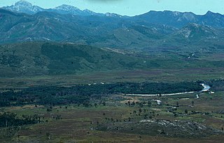
The Prince of Wales Range is a mountain range in the South West Wilderness, Tasmania, Australia. It is situated north and parallel to the Denison River. It lies to the west of Lake Gordon, and southeast of Frenchmans Cap.


