South Esk River

Last updated

South Esk
Launceston-Tasmania-Australia05.JPG
South Esk River in Launceston
South Esk River.png
Native name
Location
Country Australia
State Tasmania
RegionNorthern Tasmania
Physical characteristics
Source Ben Lomond
  locationMathinna Plains
  elevation810 m (2,660 ft)
Source confluenceNorth Esk River
  locationTrevallyn
  coordinates 41°43′16″S147°13′06″E / 41.72111°S 147.21833°E / -41.72111; 147.21833
  elevation0 m (0 ft)
Mouth Tamar River
  location
Launceston
  coordinates
41°27′S147°07′E / 41.450°S 147.117°E / -41.450; 147.117 Coordinates: 41°27′S147°07′E / 41.450°S 147.117°E / -41.450; 147.117
  elevation
0 m (0 ft)
Length252 km (157 mi)
Basin features
River system Tamar River
Tributaries 
  left River Tyne, Break O'Day River, St Pauls River, Meander River
  right Nile River, Macquarie River, North Esk River
Reservoirs Lake Trevallyn
[1] [2]

The South Esk River, the longest river in Tasmania, [2] is a major perennial river located in the northern region of Tasmania, Australia.

Contents

Location and features

The South Esk springs from the eastern foothills of the Ben Lomond plateau near Mathinna and the river's course describes an arc around the entire southern promontory of the mountain – running through Fingal, Avoca and Evandale before winding its way northwest through Perth, Longford and Hadspen. The river merges with the tributary Meander River, then flows through the narrows of the Cataract Gorge to finally meet the North Esk River at Launceston. From this confluence arises kanamaluka/Tamar River, which runs to the Bass Strait.

The natural river flow is interrupted by the Trevallyn Dam, near Launceston, constructed as part of the Trevallyn Power Station hydroelectric power scheme. The river is subject to flooding which overflows at Lake Trevallyn to create the spectacle of high rapids coursing through the narrows of the Gorge.

The river's two largest tributaries are the Macquarie and Meander Rivers, with lesser tributaries being the Nile River, River Tyne, Storys Creek and the Break O'Day River – upstream of the junction with the Macquarie. The Meander's main tributaries are the Liffey River and Quamby Brook and the Macquarie's main tributaries are the Lake, Isis, Elizabeth, Blackman, and Tooms rivers. These tributary watercourses drain the entire north Midlands valley, the watersheds of the Western Tiers, Ben Lomond plateau and Eastern Ranges south of Ben Lomond.

History

Indigenous history

The river is known in palawa kani, the language of Tasmanian Aborigines, as plipatumila. Other recorded Tasmanian Aboriginal names for the river are mangana lienta (from the word menanyer meaning 'large stream' and liena – either fresh water or related to a word for the Fingal Valley) [3] [4] :9,51 [5] :142,372 and mooronnoe [4] (the Northern reach around modern day Hadspen).

The South Esk River runs through, and forms the borders of, traditional lands of two nations of the Palawa. The Ben Lomond Nation occupied territory enclosed by the river's western and southern stretches and occupied the entire upper reaches as far as its northern watershed. [6] The Panninher, Tyrernotepanner and Leterremairrener clans of the North Midlands Nation occupied the territories to the west of the river. The Aboriginal clans exploited the hunting grounds alongside the river and took the native freshwater mussel for food. [7]

The river was frequented by Aboriginal people and remnants of their campsites and toolmaking have been found along the river. The ethnographic record describes particular meeting areas, or 'resorts', on the river; such as Stony Creek, near Llewellyn; Glen Esk (near Nile); Native Point, near Perth; and at Hadspen. [7] [8]

European history

The river was renamed by Colonel William Paterson in December 1804 after the eponymous Scottish river. [9]

See also

Related Research Articles

Councils of Tasmania are the 29 administrative districts of the Australian state of Tasmania. Local government areas (LGAs), more generally known as councils, are the tier of government responsible for the management of local duties such as road maintenance, town planning and waste management.

<span class="mw-page-title-main">Aboriginal Tasmanians</span> Indigenous people of the Australian island state of Tasmania

The Aboriginal Tasmanians are the Aboriginal people of the Australian island of Tasmania, located south of the mainland. For much of the 20th century, the Tasmanian Aboriginal people were widely, and erroneously, thought of as being an extinct cultural and ethnic group that had been intentionally exterminated by white settlers. Contemporary figures (2016) for the number of people of Tasmanian Aboriginal descent vary according to the criteria used to determine this identity, ranging from 6,000 to over 23,000.

<span class="mw-page-title-main">Launceston, Tasmania</span> City in Tasmania, Australia

Launceston or is a city in the north of Tasmania, Australia, at the confluence of the North Esk and South Esk rivers where they become the Tamar River (kanamaluka). As of 2021, Launceston has a population of 87,645. Launceston is the second most populous city in Tasmania after the state capital, Hobart. As of 2020, Launceston is the 18th largest city in Australia. Launceston is fourth-largest inland city and the ninth-largest non-capital city in Australia. Launceston is regarded as the most liveable regional city, and was one of the most popular regional cities to move to in Australia from 2020 to 2021. Launceston was named Australian Town of the Year in 2022.

<span class="mw-page-title-main">Tasmanian languages</span> Languages indigenous to the island of Tasmania that were used by Aboriginal Tasmanians

The Tasmanian languages were the languages indigenous to the island of Tasmania, used by Aboriginal Tasmanians. The languages were last used for daily communication in the 1830s, although the terminal speaker, Fanny Cochrane Smith, survived until 1905.

<span class="mw-page-title-main">Ben Lomond (Tasmania)</span> Mountain in the north of Tasmania

Ben Lomond is a mountain in the north-east of Tasmania, Australia.

<span class="mw-page-title-main">Deddington, Tasmania</span> Town in Tasmania, Australia

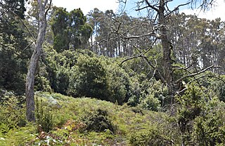
Deddington is a rural locality in the local government area (LGA) of Northern Midlands in the Central LGA region of Tasmania. The locality is about 34 kilometres (21 mi) east of the town of Longford. The 2016 census has a population of 121 for the state suburb of Deddington. The town is situated on the Nile River and lies in the foothills of Ben Lomond.

<span class="mw-page-title-main">North Esk River</span> River in northern Tasmania, Australia

The North Esk River is a major perennial river located in the northern region of Tasmania, Australia.

<span class="mw-page-title-main">Carrick, Tasmania</span> Town in Tasmania, Australia

Carrick is a small historic village 17 kilometres (11 mi) west of Launceston, Tasmania, Australia, on the banks of the Liffey River. The Meander Valley Highway passes through the town's centre; this road was formerly the main road from Launceston to Deloraine and Devonport. Carrick has a well-preserved 19th-century heritage; fifteen of its colonial buildings are listed on the Tasmanian Heritage Register including Carrick House (1840), St Andrew's Church (1848), the Old Watch house (1837), Monds Roller Mill (1846) and the Carrick Hotel (1833).

<span class="mw-page-title-main">Evandale, Tasmania</span> Town in Tasmania, Australia

Evandale is an historic town in northern Tasmania, Australia. It sits on the banks of the South Esk River, 18 km south of Launceston. Named after early colonial explorer and Surveyor-General George Evans, the town is famous for its late-Georgian and early-Victorian buildings with relatively untouched streetscape, a popular Sunday market and as a host to the annual World Penny Farthing bicycle Championships. At the 2016 census, Evandale had a population of 1,345.

<span class="mw-page-title-main">Electoral division of Launceston</span> Electoral division of the Tasmanian Legislative Council

The electoral division of Launceston is one of 15 electorates or seats in the Tasmanian Legislative Council, created in 2008. It also previously existed until 1999, when it was abolished and substantially incorporated into the new division of Paterson, which was in turn abolished in 2008.

<span class="mw-page-title-main">Trevallyn, Tasmania</span> Suburb of Launceston, Tasmania, Australia

Trevallyn is a residential locality in the local government areas (LGAs) of Launceston (25%) and West Tamar (75%) in the Launceston LGA region of Tasmania. The locality is about 3 kilometres (1.9 mi) west of the town of Launceston. The 2016 census recorded a population of 4562 for the state suburb of Trevallyn. It is a suburb of Launceston.

<span class="mw-page-title-main">Campbell Town, Tasmania</span> Town in Tasmania, Australia

Campbell Town is a town in Tasmania, Australia, on the Midland Highway. At the 2006 census, the town had a population of 772.

<span class="mw-page-title-main">Hadspen, Tasmania</span> Town in Tasmania, Australia

Hadspen is a town on the South Esk River in the north of Tasmania, Australia, 8 kilometres (5.0 mi) south west of Launceston. Hadspen has few commercial establishments and is primarily a residential suburb of nearby Launceston. Most of the town's buildings are residential, and relatively recent. The town's population of just over 2000 has grown rapidly from only a few hundred in the 1960s, and there are development plans that call for its doubling.

The Macquarie River is a major perennial river located in the Midlands region of Tasmania, Australia.

<span class="mw-page-title-main">Stacks Bluff</span>

The Stacks Bluff is a peak in northeast Tasmania, Australia. The mountain is situated on the Ben Lomond plateau.

<span class="mw-page-title-main">Lake Leake, Tasmania</span> Town in Tasmania, Australia

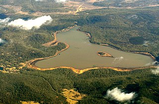
Lake Leake is the name of both a man-made water storage reservoir and a small township in the eastern midlands of Tasmania. The locality is split between two local authorities, as follows:

Travellers Rest is a rural/residential locality in the local government areas (LGA) of Meander Valley (98%) and Northern Midlands (2%) in the Launceston and Central LGA regions of Tasmania. The locality is about 24 kilometres (15 mi) east of the town of Westbury. The 2016 census recorded a population of 305 for the state suburb of Travellers Rest. It is a settled semi-rural area at the edge of Greater Launceston.

<span class="mw-page-title-main">Elizabeth River (Tasmania)</span> River in Tasmania, Australia

The Elizabeth River is a minor perennial river located in the Somerset Land District, in the Midlands region of Tasmania, Australia.

<span class="mw-page-title-main">Liffey River (Tasmania)</span> River in Tasmania, Australia

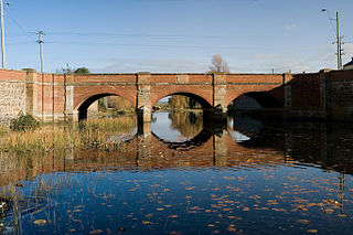
The Liffey River is a river in Northern Tasmania, Australia.

<span class="mw-page-title-main">Conara, Tasmania</span> Town in Tasmania, Australia

Conara is a rural locality in the local government area (LGA) of Northern Midlands in the Central LGA region of Tasmania. The locality is about 50 kilometres (31 mi) south-east of the town of Longford. The 2016 census recorded a population of 130 for the state suburb of Conara.

References

  1. "Map of South Esk River, TAS". Bonzle Digital Atlas of Australia. 2015. Retrieved 18 June 2016.
  2. 1 2 "1384.6 - Statistics - Tasmania, 2008". Bureau of Statistics. Australian Government. 3 January 2008. Retrieved 18 June 2016.
  3. Milligan, Joseph (1866). Vocabulary of dialects of Aboriginal tribes of Tasmania. Hobart: James Barnard: Government printer.
  4. 1 2 Taylor, John (1996). "Dictionary of Palawa place names". State Library of Tasmania/Riuwanna - UTAS.
  5. Plomley, Brian (1976). A Word-list of the Tasmanian Aboriginal Languages. Hobart, Tas: The State of Tasmania.
  6. Ellis, R.C. (January 1984). "Aboriginal Influences on Vegetation in the Northeast Highlands". Tasmanian Naturalist: 7–8.
  7. 1 2 Kee, Sue (1990). Midlands aboriginal archaeological site survey. Hobart: Dept. of Parks, Wildlife and Heritage. ISBN   0724617388.
  8. Stancombe, Hawley (1968). Highway in Van Diemen's Land. Glendessary, Western Junction: G. Hawley Stancombe. ISBN   0959929312.
  9. Bladen, F. M. (Frank Murcott), ed. (1897), Historical records of New South Wales, Volume 5King, 1803-1805, Sydney: Charles Potter, Government Printer, p. 497, archived from the original on 30 March 2011