
Launceston is a city in the north of Tasmania, Australia, at the junction of the North Esk and South Esk rivers where they become the Tamar River (kanamaluka). With a population of 87,328, Launceston is the second most populous city in Tasmania after the state capital, Hobart, and the fifth-largest inland city in Australia.

Longford is a town in the northern midlands of Tasmania, Australia. It lies 145 m above sea level at the convergence of the Macquarie River and the South Esk River, 21 km south of Launceston and a 15-minute drive from the airport. It is just south of the Illawarra Road, a road connecting the Bass and Midland Highways. It has a population of 3,863 and is part of the Northern Midlands Council area. The region is predominantly agricultural, noted for wool, dairy produce and stock breeding.

Bracknell is a rural locality and town in the local government areas of Meander Valley and Northern Midlands in the Launceston and Central regions of Tasmania. The locality is about 22 kilometres (14 mi) south-east of the town of Westbury. The 2016 census has a population of 459 for the state suburb of Bracknell.

Ben Lomond is a mountain in the north-east of Tasmania, Australia.
Deddington is a rural locality in the local government area (LGA) of Northern Midlands in the Central LGA region of Tasmania. The locality is about 34 kilometres (21 mi) east of the town of Longford. The 2016 census has a population of 121 for the state suburb of Deddington. The town is situated on the Nile River and lies in the foothills of Ben Lomond.
The mines of the West Coast of Tasmania have a rich historical heritage as well as an important mineralogical value in containing or having had found, specimens of rare and unusual minerals. Also, the various mining fields have important roles in the understanding of the mineralization of the Mount Read Volcanics, and the occurrence of economic minerals.
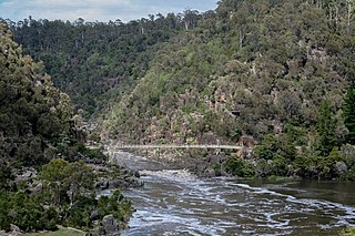
The South Esk River, the longest river in Tasmania, is a major perennial river located in the northern region of Tasmania, Australia.

Lilydale, originally known as Upper Piper, is a small town in northern Tasmania, Australia. The town is 28 kilometres (17 mi) northeast of Launceston and is a part of the Launceston municipality. It is located near Mount Arthur. At the 2006 census, Lilydale had a population of 288. The town's notable attractions include the Lilydale Falls, two small waterfalls, Mount Arthur, and, along the main street, a series of telegraph poles painted with murals.

Carrick is a small historic village 17 kilometres (11 mi) west of Launceston, Tasmania, Australia, on the banks of the Liffey River. The Meander Valley Highway passes through the town's centre; this road was formerly the main road from Launceston to Deloraine and Devonport. Carrick has a well-preserved 19th-century heritage; fifteen of its colonial buildings are listed on the Tasmanian Heritage Register including Carrick House (1840), St Andrew's Church (1848), the Old Watch house (1837), Monds Roller Mill (1846) and the Carrick Hotel (1833).

Evandale is a historic town in northern Tasmania, Australia. It sits on the banks of the South Esk River, 18 km south of Launceston. The town is famous for its late-Georgian and early-Victorian buildings with relatively untouched streetscape, a popular Sunday market and as a host to the annual World Penny Farthing bicycle Championships. At the 2016 census, Evandale had a population of 1,345.

Callington Mill is a Lincolnshire tower mill built in 1837 in Oatlands, Tasmania by John Vincent. It has recently been restored so that it is now in full working order and is the only operating mill of its type in the Southern Hemisphere. It is the third oldest windmill in Australia. Traditional baker and blacksmith Alan Scott was a central figure at the mill. Today the mill is a major tourist attraction of Oatlands. Visitors are able to climb the internal stairs for a view across Oatlands and surrounds. The mill site comprises the windmill, a granary, stable, miller’s cottage and mill owner’s house.

Campbell Town is a town in Tasmania, Australia, on the Midland Highway. At the 2006 census, the town had a population of 772.

Hadspen is a town on the South Esk River in the north of Tasmania, Australia, 8 kilometres (5.0 mi) south west of Launceston. Hadspen has few commercial establishments and is primarily a residential suburb of nearby Launceston. Most of the town's buildings are residential, and relatively recent. The town's population of just over 2000 has grown rapidly from only a few hundred in the 1960s, and there are development plans that call for its doubling.

The Stacks Bluff is a peak in northeast Tasmania, Australia. The mountain is situated on the Ben Lomond plateau.
Colin Mansfield Campbell was an Australian rules footballer who played for Essendon Football Club in the Victorian Football League (VFL) and a first-class cricketer, representing Tasmania.
John Campbell Climie (1828–1916) was a Scottish-born engineer who worked in Australia and New Zealand. He may have been working in Melbourne as early as 1856, when Austin, Climie & Co called for tenders for erecting a dwelling house for A. Grant at 193 Lonsdale St East, while he was resident in Caulfield near Melbourne by 1859.
Conara is a small township in the Northern Midlands of Tasmania, located approximately 51 kilometres (33 mi) south of Launceston. In the 2011 census, Conara had a population of 424.
John Gardner was a Scots-born Presbyterian minister in Adelaide, South Australia, the first incumbent of Chalmers Free Church of Scotland, now Scots Church, North Terrace, Adelaide. He later served at Launceston, Tasmania and Queenscliff, Victoria.

Heinrich Wilhelm Ferdinand "Ferd" Kayser, was the mine manager of Mount Bischoff Tin Mining Company for thirty years.
The Tamar Hematite Iron Company (THIC) was an iron mining and smelting company that operated from April 1874 to December 1877, in the area close to the location of the modern-day township of Beaconsfield, Tasmania, Australia.
