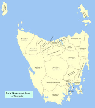
Tasman Council is a local government body in Tasmania, situated in the south-east of the state. Tasman is classified as a rural local government area and has a population of 2,404, the region covers both the Tasman and Forestier peninsulas, with Nubeena the principal town.

Derwent Valley Council is a local government body situated in southern-central Tasmania, west of Hobart. Derwent Valley is classified as a rural local government area and has a population of 10,290, it includes the localities of Bushy Park, Maydena and Strathgordon, with New Norfolk the major, principal town.

Glamorgan-Spring Bay Council is a local government body in Tasmania, situated on the central east coast of the state. Glamorgan-Spring Bay is classified as a rural local government area and has a population of 4,528, the major towns of the region include Bicheno, Orford and Triabunna with Swansea the principal town.
Dorset Council is a local government body in Tasmania, located in the far north-east of the state mainland. Dorset is classified as a rural local government area and has a population of 6,652. The major towns and localities of the region include Bridport, Derby and Ringarooma with Scottsdale the regional centre.

Meander Valley Council is a local government body in northern Tasmania. It covers the western outskirts of Launceston, and further westward along the Meander River. Meander Valley Council is classified as a rural local government area and has a population of 19,713. Major towns and localities of the region include Elizabeth Town, Mole Creek, Westbury and the principal town of Deloraine.

Central Coast Council is a local government body in Tasmania, situated in the north-west of the state between Burnie and Devonport. Central Coast is classified as an urban local government area and has a population of 21,904, Ulverstone and Penguin are the two primary towns of the region.

Kentish Council is a local government body in Tasmania, situated in the north-west of the state, to the south and inland from Devonport. Kentish is classified as a rural local government area and has a population of 6,324, the major towns of the municipality are Sheffield, Railton and Wilmot.
Waratah-Wynyard Council is a local government body in Tasmania, situated in the north-west of the state. Waratah-Wynyard is classified as a rural local government area and has a population of 13,800, the major towns and localities of the region include Savage River, Sisters Beach, Somerset, Waratah and the principal town of Wynyard.

Circular Head Council is a local government body in Tasmania covering the far north-west mainland. It is classified as a rural local government area with a population of 8,066, and its major towns and localities include Arthur River, Marrawah and Stanley, with Smithton being the largest and principal town. The origin of the name “Circular Head” is unknown.

Central Highlands Council is a local government body in Tasmania, encompassing the Central Highlands region of the state. Central Highlands is classified as a rural local government area and has a population of 2,144, the two largest towns are Bothwell and Hamilton.

Southern Midlands is a local government body in Tasmania, covering the southern region of the Tasmanian central midlands. Southern Midlands is classified as a rural local government area and has a population of 6,118, the major localities of the region include Campania, Kempton, Mangalore and the principal town of Oatlands.
Brighton Council is a local government body in Tasmania, situated in the south-east of the state, north of Hobart. The Brighton local government area is classified as urban and has a population of 18,995, it is based in the town of Brighton but also covers the far northern Hobart suburbs of Bridgewater, Gagebrook, Honeywood and Old Beach.

Sorell Council is a local government body in Tasmania, situated in the south-east of the state. The Sorell local government area is classified as rural and has a population of 15,218, the major centres of the region include Dodges Ferry, Dunalley, Primrose Sands and the principal town of Sorell.
George Town Council is a local government body in northern Tasmania, situated north of Launceston. The George Town local government area is classified as rural and has a population of 6,931, it encompasses the principal town, George Town, and the nearby localities including Hillwood, Low Head and Pipers River.

Launceston City Council is a local government body in Tasmania, located in the city and surrounds of Launceston in the north of the state. The Launceston local government area is classified as urban and has a population of 67,449, which also encompasses the localities including Lilydale, Targa and through to Swan Bay on the eastern side of the Tamar River.

Latrobe Council is a local government body in Tasmania, situated in the north of the state, east of Devonport. The Latrobe local government area is classified as rural and has a population of 11,329, it encompasses the principal town, Latrobe, and the nearby localities including Port Sorell, Sassafras and Wesley Vale.
King Island Council is a local government body in Tasmania, encompassing King Island and the adjacent minor islands within Bass Strait, in the north-west of the state. The King Island local government area is classified as rural and has a population of 1,601, with Currie as the main town and administrative centre.

Flinders Council is a local government body in Tasmania, encompassing the Furneaux Group and nearby islands of Bass Strait, in the north-east of the state. Flinders is classified as a rural local government area and has a population of 987, with Whitemark the main town located on Flinders Island.
Former Local government areas (LGAs) in the Australian state of Tasmania are amalgamated or cancelled areas.
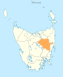
Western Junction is a semi-rural locality and town in the local government area of Northern Midlands in the Central region of Tasmania. It is located about 12 kilometres (7.5 mi) north-east of the town of Longford. The 2016 census determined a population of 125 for the state suburb of Western Junction.