
Meander Valley Council is a local government body in northern Tasmania. It covers the western outskirts of Launceston, and further westward along the Meander River. Meander Valley Council is classified as a rural local government area and has a population of 19,713. Major towns and localities of the region include Elizabeth Town, Mole Creek, Westbury and the principal town of Deloraine.
Westbury is a town in the central north of Tasmania, Australia. It lies 30 km west of Launceston on the Bass Highway, and at the 2021 census had a population of 2,272. It is part of, and the headquarters of, the Meander Valley Council area.
Meander is a rural locality and town in the local government area of Meander Valley in the Launceston region of Tasmania. The locality is about 34 kilometres (21 mi) south-west of the town of Westbury. The 2016 census has a population of 328 for the state suburb of Meander.
Cressy is a small town 35 kilometres (22 mi) south-west of Launceston, Tasmania. It came into existence in the 1850s to service the surrounding wheat farms. At the 2006 census, Cressy had a population of 670. It is known as Tasmania's "Trout capital" for the good fishing in the area. It is also home to an extensive agriculture research facility for the Tasmanian Institute of Agricultural Research.

Liffey is a rural locality and town in the local government areas of Meander Valley and Northern Midlands in the Launceston and Central regions of Tasmania. The locality is about 24 kilometres (15 mi) south of the town of Westbury. The 2016 census has a population of 155 for the state suburb of Liffey. It was named by Captain William Moriarty, from Ireland. The town is situated in rainforest, on the Liffey River at the foot of the Great Western Tiers. Nearby towns are Bracknell and Blackwood Creek.

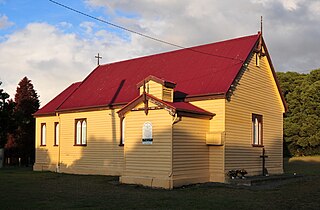
Bishopsbourne is a rural locality in the local government area (LGA) of Northern Midlands in the Central LGA region of Tasmania. The locality is about 19 kilometres (12 mi) south-west of the town of Longford. The 2016 census has a population of 136 for the state suburb of Bishopsbourne. It is a farming community and has a church, graveyard and recreation ground. Nearby towns include Carrick, Bracknell and Longford. Almost all the houses and farms are located on Bishopsbourne Road and there are a few back roads. There has been increased activity of development in recent years, though none of it has been commercial.

Caveside is a rural locality in the local government area of Meander Valley in the Launceston region of Tasmania. The locality is about 45 kilometres (28 mi) south-west of the town of Westbury. It lies between the Great Western Tiers to the south and Mole Creek to the north. The 2016 census has a population of 133 for the state suburb of Caveside.

Carrick is a small historic village 17 kilometres (11 mi) west of Launceston, Tasmania, Australia, on the banks of the Liffey River. The Meander Valley Highway passes through the town's centre; this road was formerly the main road from Launceston to Deloraine and Devonport. Carrick has a well-preserved 19th-century heritage; fifteen of its colonial buildings are listed on the Tasmanian Heritage Register including Carrick House (1840), St Andrew's Church (1848), the Old Watch house (1837), Monds Roller Mill (1846) and the Carrick Hotel (1833).

Mole Creek is a town in the upper Mersey Valley, in the central north of Tasmania, Australia. Mole Creek is well known for its honey and accounts for about 35 percent of Tasmania's honey production. The locality is in the Meander Valley Council area, but with about 3% in the Kentish Council LGA.

Elizabeth Town is a populated rural area in Meander Valley, Tasmania bisected by the Bass Highway, midway between Devonport and Launceston.

Hadspen is a town on the South Esk River in the north of Tasmania, Australia, 8 kilometres (5.0 mi) south west of Launceston. Hadspen has few commercial establishments and is primarily a residential suburb of nearby Launceston. Most of the town's buildings are residential, and relatively recent. The town's population of just over 2000 has grown rapidly from only a few hundred in the 1960s, and there are development plans that call for its doubling.
Prospect Vale is a rural/residential locality in the local government areas (LGA) of Launceston (1%) and Meander Valley (99%) in the Launceston LGA region of Tasmania. The locality is about 7 kilometres (4.3 mi) south-west of the town of Launceston. The 2016 census recorded a population of 5067 for the state suburb of Prospect Vale. It is a small suburb of Greater Launceston. Prospect Vale has a small shopping centre, Prospect Vale Marketplace, containing a Woolworths supermarket and a small industrial park lies within its boundaries. Sporting grounds include the St Patrick's Old Collegians Football Club Oval, who compete in the Northern Tasmania Football Association.
Travellers Rest is a rural/residential locality in the local government areas (LGA) of Meander Valley (98%) and Northern Midlands (2%) in the Launceston and Central LGA regions of Tasmania. The locality is about 24 kilometres (15 mi) east of the town of Westbury. The 2016 census recorded a population of 305 for the state suburb of Travellers Rest. It is a settled semi-rural area at the edge of Greater Launceston.

The Liffey River is a river in Northern Tasmania, Australia.
Whitemore is a rural locality and small town in the local government area of Meander Valley in the Launceston region of Tasmania. The locality is about 11 kilometres (6.8 mi) south-east of the town of Westbury. The 2016 census has a population of 198 for the state suburb of Whitemore.

Hagley is a rural locality and town in the local government area of Meander Valley in the Launceston region of Tasmania. The locality is about 5 kilometres (3.1 mi) north-east of the town of Westbury. The 2016 census has a population of 335 for the state suburb of Hagley.
Exton is a rural locality in the local government area of Meander Valley in the Launceston region of Tasmania. The locality is about 10 kilometres (6.2 mi) west of the town of Westbury. It lies on the outskirts of Deloraine, that lies next to the railway line from Launceston to Devonport. Its population was estimated at 200 in 1932, and the 2011 census reported the area of Reedy Marsh, which incorporated Exton, had a population of 309 people. The 2016 census has a population of 154 for the state suburb of Exton.
Chudleigh is a rural locality in the local government area of Meander Valley in the Launceston region of Tasmania. The locality is about 37 kilometres (23 mi) west of the town of Westbury. The 2016 census has a population of 203 for the state suburb of Chudleigh.
The Tasmanian Heritage Register is the statutory heritage register of the Australian state of Tasmania. It is defined as a list of areas currently identified as having historic cultural heritage importance to Tasmania as a whole. The Register is kept by the Tasmanian Heritage Council within the meaning of the Tasmanian Historic Cultural Heritage Act 1995. It encompasses in addition the Heritage Register of the Tasmanian branch of the National Trust of Australia, which was merged into the Tasmanian Heritage Register. The enforcement of the heritage's requirements is managed by Heritage Tasmania.
