Councils of Tasmania are the 29 administrative districts of the Australian state of Tasmania. Local government areas (LGAs), more generally known as councils, are the tier of government responsible for the management of local duties such as road maintenance, town planning and waste management.

Kingston is a town on the outskirts of Hobart, Tasmania, Australia. Nestled 12 km south of the city between and around several hills, Kingston is the seat of the Kingborough Council, and today serves as the gateway between Hobart and the D'Entrecasteaux Channel region, which meets the Derwent River nearby. It is one of the fastest-growing regions in Tasmania. The Kingston-Huntingfield statistical area had an estimated population of 11,200 in June 2012.

Margate is a small seaside town on the Channel Highway between North-West Bay and the Snug Tiers, 7 kilometres (4 mi) south of Kingston in Tasmania, Australia. It is mostly in the Kingborough Council area, with about 4% in the Huon Valley Council LGA.
Kingborough Council is a local government body in Tasmania, and one of the five municipalities that constitutes the Greater Hobart Area. Kingborough is classified as an urban local government area and has a population of 37,734, it covers the transition from the southern urban areas of Hobart through Kingston, as well as encompassing Bruny Island.

Sandy Bay is a suburb of the city of Hobart, Tasmania, Australia, located immediately south of the central business district, and adjoining the suburb of Battery Point. Sandy Bay is bounded on the east by the Derwent River, and has several beaches along the shore, the main beaches with public access are Nutgrove Beach and Long Beach.
The 1967 Tasmanian fires were an Australian natural disaster which occurred on 7 February 1967, an event which came to be known as the Black Tuesday bushfires. They were the most deadly bushfires that Tasmania has ever experienced, leaving 62 people dead, 900 injured and over seven thousand homeless.
The D'Entrecasteaux Channel is a body of water located between Bruny Island and the south-east of the mainland of Tasmania, Australia. The channel is the mouth for the estuaries of the Derwent and the Huon Rivers and empties into the Tasman Sea of the South Pacific Ocean. It was sighted by Abel Tasman in 1642 and surveyed in 1792 by Bruni d'Entrecasteaux.

The Huon Valley, or simply the Huon is a valley and geographic area located in southern Tasmania, Australia. The largest town is Huonville, with other smaller towns spread across the area. It includes Australia's most southern permanent settlement at Southport. The Huon Valley Council area had a population of 15,140 in 2011. Famed for its apple growing, the Valley was first settled by British colonists in the 1820s; prior to settlement the Huon Valley area was inhabited by the Mouheneenner, Nuenonne, Mellukerdee and Lyluequonny people.

Bonnet Hill is a residential locality in the local government area (LGA) of Kingborough in the Hobart LGA region of Tasmania. The locality is about 2 kilometres (1.2 mi) east of the town of Kingston. The 2016 census provides a population of 505 for the state suburb of Bonnet Hill.
Firthside is a neighbourhood within the suburb of Kingston, in the greater Hobart area, capital of Tasmania, Australia. It is located on the northern edge of the Kingston urban area.

Kingston Beach is a residential locality in the local government area (LGA) of Kingborough in the Hobart LGA region of Tasmania. The locality is about 2 kilometres (1.2 mi) south-east of the town of Kingston. The 2016 census provides a population of 1990 for the state suburb of Kingston Beach.
Huntingfield is a residential locality in the local government area (LGA) of Kingborough in the Hobart LGA region of Tasmania. The locality is about 3 kilometres (1.9 mi) south-west of the town of Kingston. The 2016 census provides a population of 428 for the state suburb of Huntingfield.

Kingborough Tigers Football Club is an Australian rules football club, based at Kingston, Tasmania that formerly competed in the Southern Football League in Tasmania before progressing to representation in the statewide Tasmanian State Football League (TSL) in 2014.
Alonnah is a rural locality on Bruny Island in the local government area (LGA) of Kingborough in the Hobart LGA region of Tasmania. The locality is about 60 kilometres (37 mi) south of the town of Kingston. The 2016 census provides a population of 137 for the state suburb of Alonnah.
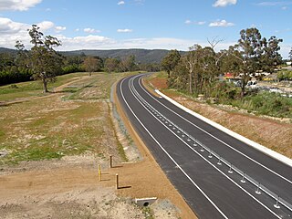
The Kingston Bypass is a A$41 million, 2.8-kilometre-long (1.7 mi) highway bypassing the southern Hobart community of Kingston, Tasmania. The proposal of a bypass was originally published in the Hobart Area Transportation Study during 1965. The bypass was completed in 2011, after the need to such a road was realised several years earlier when the Channel Highway reached an 18,000 AADT. Construction of the Bypass was made possible by an A$15 million pledge for the project, made by the Australian Labor Party during the 2007 federal election campaign. During construction total cost of the bypass blew out from the original estimate of $30 million to over $41 million.

Sandfly is a suburb in the Kingborough Council local government area in Tasmania, Australia. A region of the Franklin Electorate, Sandfly is a historic area that sits between the suburbs of Longley, Lower Longley, Allens Rivulet, Margate, Leslie Vale and Kaoota. The population of Sandfly in 2011 was 156.

The Kingborough Sports Centre (KSC), is a multi-purpose sports venue located in the southern Hobart (Tasmania) suburb of Kingston. The centre was opened on 19 May 1979 and since opening has become a vital part of the Kingborough Community.
The Peter Murrell Conservation Area is located in Huntingfield, Tasmania, approximately 15 km (9.3 mi) south of the state's capital city, Hobart. The conservation area has an area of 135 ha and is one of three reserves within the Peter Murrell Reserves. Also within these reserves are the Peter Murrell State Reserve and a Public Reserve. These reserves and the Conservation Area lie at the base of the Tinderbox Peninsula, between the suburbs of Kingston, Howden and Blackman's Bay. The Peter Murrell Conservation Area surrounds the northern, western and southern sides of the Peter Murrell State Reserve.
Pelverata is a rural locality in the local government areas (LGA) of Huon Valley and Kingborough in the South-east and Hobart LGA regions of Tasmania. The locality is about 22 kilometres (14 mi) south-west of the town of Kingston. The 2016 census provides a population of 206 for the state suburb of Pelverata. It is a town in Tasmania, Australia, to the east of Huonville. It is mainly in the Huon Valley Council area, with about 4% in the Kingborough Council LGA.
Tinderbox is a rural residential locality in the local government area of Kingborough in the Hobart region of Tasmania. It is located about 13 kilometres (8.1 mi) south of the town of Kingston. The 2016 census has a population of 394 for the state suburb of Tinderbox.
