Forth River (Tasmania)

Last updated

Forth River at Forth. Forth-River-Tasmania-20070420-002.jpg
Forth River at Forth.

The Forth River is a perennial river located in northwest Tasmania, Australia.

Tasmania island state of Australia

Tasmania is an island state of Australia. It is located 240 km (150 mi) to the south of the Australian mainland, separated by Bass Strait. The state encompasses the main island of Tasmania, the 26th-largest island in the world, and the surrounding 334 islands. The state has a population of around 533,308 as of March 2019. Just over forty percent of the population resides in the Greater Hobart precinct, which forms the metropolitan area of the state capital and largest city, Hobart.

Australia Country in Oceania

Australia, officially the Commonwealth of Australia, is a sovereign state comprising the mainland of the Australian continent, the island of Tasmania, and numerous smaller islands. It is the largest country in Oceania and the world's sixth-largest country by total area. The neighbouring countries are Papua New Guinea, Indonesia, and East Timor to the north; the Solomon Islands and Vanuatu to the north-east; and New Zealand to the south-east. The population of 26 million is highly urbanised and heavily concentrated on the eastern seaboard. Australia's capital is Canberra, and its largest city is Sydney. The country's other major metropolitan areas are Melbourne, Brisbane, Perth, and Adelaide.

Contents

Location and features

The lower part of the river features Lake Barrington, which is a major venue for competitive rowing. It is also the location of the village of Forth.

Lake Barrington (Tasmania) lake in Tasmania, Australia

Lake Barrington is an artificial lake in northern Tasmania, located 40 kilometres (25 mi) south of Devonport. The lake is 20 kilometres (12 mi) long and was built on the Forth River in 1969 to provide a head of water for the Devils Gate Power Station. The foreshore is protected by the Tasmanian Government as a nature recreation area.

Forth, Tasmania Town in Tasmania, Australia

Forth is a small village in north-west Tasmania on the Forth River, 11 kilometres (7 mi) west of Devonport and 110 kilometres (68 mi) north-west of Launceston via the Bass Highway. Forth has a population of about 711. Previously known as Hamilton-on-Forth, the village predates the larger settlement of Devonport. Nearby is the Forthside Dairy Research Facility run by the Tasmanian Institute of Agricultural Research.

The river is a part of the Mersey-Forth power project, which includes seven hydroelectric power stations. Three hydroelectric power stations have been built on the Forth River itself, including Cethana Power Station (impounding Lake Cethana); Devils Gate Power Station (impounding Lake Barrington); and Paloona Power Station (impounding Lake Paloona.)

Mersey River (Tasmania) river in Australia

The Mersey River is a river on the north-west coast of Tasmania, Australia. The city of Devonport is situated at the river's mouth on Bass Strait.

Cethana Power Station dam in North-western Tasmania

The Cethana Power Station is a conventional hydroelectric power station located in north-western Tasmania, Australia.

Devils Gate Power Station dam in North-western Tasmania

The Devils Gate Power Station is a conventional hydroelectric power station located in north-western Tasmania, Australia.

The upper part of the river catchment area is also known as the Forth River High Country and contains the Cradle Mountain-Lake St Clair National Park [1] with the source of the river being on the southern slopes of Mount Pelion West.

Cradle Mountain-Lake St Clair National Park Protected area in Tasmania, Australia

Cradle Mountain-Lake St Clair National Park is located in the Central Highlands area of Tasmania (Australia), 165 kilometres (103 mi) northwest of Hobart. The park contains many walking trails, and is where hikes along the well-known Overland Track usually begin. Major features are Cradle Mountain and Barn Bluff in the northern end, Mount Pelion East, Mount Pelion West, Mount Oakleigh and Mount Ossa in the middle and Lake St Clair in the southern end of the park. The park is part of the Tasmanian Wilderness World Heritage Area.

Mount Pelion West mountain

Mount Pelion West is a mountain located in the Central Highlands region of Tasmania, Australia. The mountain is part of the Pelion Range and is situated within the Cradle Mountain-Lake St Clair National Park at the eastern most boundary of the Murchison River catchment.

The catchment for the river is 1,126 square kilometres (435 sq mi). [2]

See also

Related Research Articles

Lake Pedder lake in Tasmania, Australia

Lake Pedder, once a glacial outwash lake, is a man-made impoundment and diversion lake located in the southwest of Tasmania, Australia. In addition to its natural catchment from the Frankland Range, the lake is formed by the 1972 damming of the Serpentine and Huon rivers by the Hydro Electric Commission of Tasmania for the purposes of hydroelectric power generation.

Lake Gordon reservoir

Lake Gordon is a man-made reservoir created by the Gordon Dam, located on the upper reaches of the Gordon River in the south-west region of Tasmania, Australia.

Pieman River river in western Tasmania

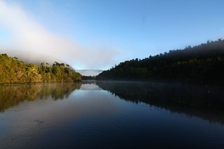
The Pieman River is a major perennial river located in the west coast region of Tasmania, Australia.

Lake Margaret (Tasmania) dam in West Coast, Tasmania

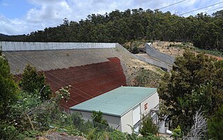
Lake Margaret is a concrete-faced gravity dam with a uncontrolled spillway across the Yolande River, located on the north side of Mount Sedgwick, in the West Coast Range, West Coast of Tasmania, Australia.

Tribute Power Station dam in Western Tasmania

The Tribute Power Station is a conventional hydroelectric power station located in Western Tasmania, Australia.

Rowallan Power Station dam in North-western Tasmania

The Rowallan Power Station is a conventional hydroelectric power station located in north-western Tasmania, Australia. The station is located 25 kilometres (16 mi) south of Liena.

Lemonthyme Power Station dam in North-western Tasmania

The Lemonthyme Power Station is a conventional hydroelectric power station located in north-western Tasmania, Australia. It is the third station in the Mersey–Forth run-of-river scheme that comprises seven conventional hydroelectric power stations and one mini hydro station.

Paloona Power Station dam in Northern Tasmania

The Paloona Power Station is a conventional hydroelectric power station located in northern Tasmania, Australia.

Wilmot Power Station dam in North-western Tasmania

The Wilmot Power Station is a conventional hydroelectric power station located in north-western Tasmania, Australia.

Murchison River (Tasmania) river in Tasmania, Australia

The Murchison River, part of the Pieman River catchment, is a major perennial river located in the West Coast region of Tasmania, Australia.

Mackintosh River river in Australia

The Mackintosh River, part of the Pieman River catchment, is a major perennial river located in the West Coast region of Tasmania, Australia.

Lake Mackintosh is a 17.5-kilometre-long (10.9 mi) reservoir with a surface area of 3,100-hectare (7,700-acre) that forms part of the Pieman power development running north-south past Mount Farrell, adjacent to the town of Tullah in Tasmania.

Scotts Peak Dam dam in South West Tasmania

The Scotts Peak Dam is a rockfill embankment dam without a spillway across the Huon River, located in the South West region of Tasmania, Australia.

Serpentine Dam (Tasmania) dam in South West Tasmania

The Serpentine Dam is a rockfill embankment dam with a concrete face and a controlled spillway across the Serpentine River, located in the South West region of Tasmania, Australia.

The Anthony Power Development Scheme, part of the Pieman River power development scheme, was a proposed scheme for damming parts of the upper catchment of the Pieman River in Western Tasmania, Australia.

Moina, Tasmania Town in Tasmania, Australia

Moina is a town 45 km inland from Devonport on the north-west coast of Tasmania, Australia. Moina was the site of a brief gold rush in the late nineteenth century and then one of the largest wolfram and bismuth mines in Tasmania. It has been the centre of continued mineral exploration in the Middlesex district since the first discoveries of tin and tungsten ores on Dolcoath Hill in the 1890s. The name may be a derivation of a small crustacean of the same name found in Tasmanian waters.

Parangana Power Station dam in North-western Tasmania

The Parangana Power Station is a mini-hydro power station located in north-western Tasmania, Australia. It is located below the rock-filled/clay core Parangana Dam which forms Lake Parangana. It is the only mini hydro electric power station in the Mersey–Forth run-of-river scheme that also contains seven conventional hydroelectric power stations.

References

  1. Haygarth, Nick (1998) A View to Cradle: A History of Tasmania's Forth River High Country ISBN   0-646-34293-2
  2. http://www.environment.gov.au/ssd/publications/ssr/pubs/ssr167.pdf

Coordinates: 41°37′S146°08′E / 41.61°S 146.13°E / -41.61; 146.13

Geographic coordinate system Coordinate system

A geographic coordinate system is a coordinate system that enables every location on Earth to be specified by a set of numbers, letters or symbols. The coordinates are often chosen such that one of the numbers represents a vertical position and two or three of the numbers represent a horizontal position; alternatively, a geographic position may be expressed in a combined three-dimensional Cartesian vector. A common choice of coordinates is latitude, longitude and elevation. To specify a location on a plane requires a map projection.