Mersey River (Tasmania)

Last updated

Mersey River
Mersey River, Tasmania 01.jpg
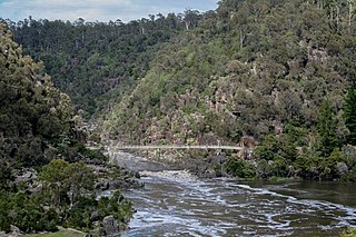
Mersey River near Latrobe
Relief Map of Tasmania.png
Red pog.svg
Location
Country Australia
State Tasmania
Physical characteristics
Source Lake Meston
  location Walls of Jerusalem National Park
  coordinates 41°53′56″S146°13′40″E / 41.89889°S 146.22778°E / -41.89889; 146.22778
  elevation1,022 m (3,353 ft)
Mouth  
  location
Devonport
  coordinates
Coordinates: 41°10′S146°22′E / 41.167°S 146.367°E / -41.167; 146.367
Length147 km (91 mi) [1]
Basin features
Bridges Victoria Bridge, Devonport
Inland ports Port of Devonport
The Estuary of the Mersey River at Devonport. Mersey-river-20070325-003.jpg
The Estuary of the Mersey River at Devonport.

The Mersey River is a river on the north-west coast of Tasmania, Australia. The city of Devonport is situated at the river's mouth on Bass Strait.

Contents

The source of this river is Lake Meston. From here the river feeds itself into Lake Youd.

Lees Creek is a tributary to the Mersey River and it feeds into Lake Orion, Lake Merope, Lake Eros, Lake Artemis and Junction Lake prior to the Mersey.

Feather Creek from Cathedral Mountain is a tributary to the Mersey River at this point. Campfire Creek is the next tributary.

The Mersey flows into Lake Rowallan. The Rowallan Power Station, [2] part of the Rowallan Dam is a hydro-electric station is also located on the Mersey.

Fish Creek is also a tributary to Lake Rowallan.

The Mersey then flows to Lake Parangana.

Lake Parangana also takes inflows from the Fisher River, this has a tributary of the little Fisher River and Fisher River flows through Lake MacKenzie and the Fisher Power Station which also has a tributary from Explorer Creek which is fed from Lake Explorer.

Water from Lake Parangana is transferred west via tunnels to Lemonthyme Power Station. The water runs into Lake Cethana.

The Mersey River continues to flow from Lake Parangana through Parangana Power Station and takes in Overflow Creek and Mole Creek as its tributaries.

Lobster Rivulet flows into the Mersey at the next point.

The Dasher River which has York Creek as a tributary flows joins with the Minnow River and then Dasher River flows into the Mersey.

Coilers Creek, Caroline Creek and Bonney's Creek are also tributaries.

Kings Creek which has a tributary from Latrobe Creek flow into the Mersey.

Ballahoo Creek, Snag Creek, Cockers Creek, Figure of Eight Creek and Horsehead Creek are next to contribute to the flow of the Mersey River.

The Mersey flows under the Victoria Bridge and through the Port and City of Devonport.

The Mersey river finally feeds itself into Bass Strait.

In the winter of 2016 the Mersey River had a major flood [3] as a result of widespread heavy rainfall across Tasmania. The flood resulted in significant damage to bridges and other riverside infrastructure, as well as extensive erosion of the river bank and uprooting of trees, leading to numerous logjams in narrow gorges such as at Big Bend. These logjams were so extensive that the many kayakers who use the river were required to portage around them to travel downstream.

Recreation

Anglers along the Mersey Mersey River, Tasmania 05.jpg
Anglers along the Mersey

The Mersey is a popular trout fishing stream holding brown and rainbow trout. [4]

Each March long weekend is the Devonport Regatta which consists of Power Boat racing, Miss Regatta Girl, Trans Mersey Swim, greasy pole, side show alley and woodchopping events.

Whitewater rafting is popular on the river.

Latrobe's Henley-on-Mersey Regatta held on Australia Day 26 January each year at Belles Parade consists of woodchopping, Ferret racing, Triathlon, Iron Trial Strongman, Boat Race, Cherry Spitting and Gum boot throwing.

The Mersey River is also popular for water skiing.

See also

Related Research Articles

Dartmouth Dam Dam in Victoria

Dartmouth Dam is a large rock-fill embankment dam with an uncontrolled chute spillway across the Mitta Mitta, Gibbo, and Dart rivers, the Morass Creek and a number of small tributaries. The dam is located near Mount Bogong in the north-east of the Australian state of Victoria. The dam's purpose includes irrigation, the generation of hydro-electric power, water supply and conservation. The impounded reservoir is called Dartmouth Reservoir, sometimes called Lake Dartmouth. The Dartmouth Power Station, a hydro-electric power station that generates power to the national grid, is located near the dam wall.

Devonport, Tasmania City in Tasmania, Australia

Devonport is a city in northern Tasmania, Australia, located on the lands of the Pirinilaplu clan of the Palawa nation. It is situated at the mouth of the Mersey River. Devonport had an urban population of 23,046 at the 2016 Australian census. When counting the larger urban area, including Latrobe, the population total was 30,297 at June 2018. The area has grown at an average annual rate of 0.17% year-on-year over the preceding five years.

Latrobe, Tasmania Town in Tasmania, Australia

Latrobe is a town in northern Tasmania, Australia on the Mersey River. It is 8 km south-east of Devonport on the Bass Highway. It is the main centre of the Latrobe Council. At the 2006 census, Latrobe had a population of 2,843. By the 2016 census, this had increased to 4,169. The locality is in the Latrobe Council area, but with a mere 0.1% in the Kentish Council LGA.

Skagit River River in Canada and the United States

The Skagit River is a river in southwestern British Columbia in Canada and northwestern Washington in the United States, approximately 150 mi (240 km) long. The river and its tributaries drain an area of 1.7 million acres (690,000 hectares) of the Cascade Range along the northern end of Puget Sound and flows into the sound.

Sheffield, Tasmania Town in Tasmania, Australia

Sheffield is a town 23 kilometres inland from Devonport on the north-west coast of Tasmania. Sheffield has long been the rural hub for the Mount Roland area. The Sheffield area is well known for its high quality butterfat production via dairy farming. The area is suitable for lamb and beef production. The town of Railton is nearby. At the 2016 census, Sheffield had a population of 1,552.

South Esk River

The South Esk River, the longest river in Tasmania, is a major perennial river located in the northern region of Tasmania, Australia.

Jindabyne Dam Dam in Snowy Mountains, New South Wales

Jindabyne Dam is a major ungated rockfill embankment dam across the Snowy River in the Snowy Mountains of New South Wales, Australia. The dam's main purpose is for the generation of hydro-power and is one of the sixteen major dams that comprise the Snowy Mountains Scheme, a vast hydroelectricity and irrigation complex constructed in south-east Australia between 1949 and 1974 and now run by Snowy Hydro.

Cethana Power Station Dam in North-western Tasmania

The Cethana Power Station is a conventional hydroelectric power station located in north-western Tasmania, Australia.

Rowallan Power Station Dam in North-western Tasmania

The Rowallan Power Station is a conventional hydroelectric power station located in north-western Tasmania, Australia. The station is located 25 kilometres (16 mi) south of Liena.

Fisher Power Station Dam in North-western Tasmania

The Fisher Power Station is a conventional hydroelectric power station located in north-western Tasmania, Australia.

Lemonthyme Power Station Dam in North-western Tasmania

The Lemonthyme Power Station is a conventional hydroelectric power station located in north-western Tasmania, Australia. It is the third station in the Mersey–Forth run-of-river scheme that comprises seven conventional hydroelectric power stations and one mini hydro station.

Wilmot Power Station Dam in North-western Tasmania

The Wilmot Power Station is a conventional hydroelectric power station located in north-western Tasmania, Australia.

Mackintosh River River in Western Tasmania, Australia

The Mackintosh River, part of the Pieman River catchment, is a major perennial river located in the West Coast region of Tasmania, Australia. The river was named in November 1828 by Henry Hellyer, a surveyor of the Van Diemans Land Company, in honour of Sir James Mackintosh, son of John Mackintosh of Kyllachy, Inverness-shire

Scotts Peak Dam Dam in South West Tasmania

The Scotts Peak Dam is a rockfill embankment dam without a spillway across the Huon River, located in the South West region of Tasmania, Australia.

Parangana Power Station Dam in North-western Tasmania

The Parangana Power Station is a mini-hydro power station located in north-western Tasmania, Australia. It is located below the rock-filled/clay core Parangana Dam which forms Lake Parangana. It is the only mini hydro electric power station in the Mersey–Forth run-of-river scheme that also contains seven conventional hydroelectric power stations.

Liffey River (Tasmania)

The Liffey River is a river in Northern Tasmania, Australia.

John Butters Power Station Dam in Western Tasmania

The John Butters Power Station is a conventional hydroelectric power station located in Western Tasmania, Australia. The power station forms part of the King – Yolande River Power Scheme and is owned and operated by Hydro Tasmania.

Lake Mackenzie (Tasmania) Lake in Tasmania, Australia

Lake Mackenzie is a lake in the Central Highlands area of Tasmania, Australia. The lake is formed by a dam and is part of Tasmania's hydro electric scheme operated by Hydro Tasmania.

Mersey Forest, Tasmania Tasmania, Australia

Mersey Forest is a locality in the local government areas of Meander Valley and Kentish in the North West region of Tasmania. It is located about 78 kilometres (48 mi) south-west of the town of Devonport. The 2016 census determined a population of zero for the state suburb of Mersey Forest.

References

  1. "Mersey Catchment" (PDF). Department of Primary Industry Water and Environment. Retrieved 23 April 2017.
  2. "Energy Our-Power-Stations Mersey-Forth". Hydro Tasmania. Retrieved 18 April 2017.
  3. "Two People Missing, One Dead, Hundreds Rescued as Tasmania Floods". 6 June 2016.
  4. Gilmore, Don (2000). Trout Fishing Guide to Tasmania. Launceston: Telegraph Printery. p. 92. ISBN   095859905X.

Commons-logo.svg Media related to Mersey River at Wikimedia Commons