Arthur River (Tasmania)

Last updated

Arthur
Arthur River mouth.jpg
The mouth of the Arthur River
Relief Map of Tasmania.png
Red pog.svg
Location of the Arthur River mouth in Tasmania
EtymologySir George Arthur
Location
Country Australia
State Tasmania
Region North-west
Physical characteristics
SourceMagnet Range
  locationsouth of Waratah
  coordinates 41°29′43″S145°25′30″E / 41.49528°S 145.42500°E / -41.49528; 145.42500
  elevation479 m (1,572 ft)
Mouth Southern Ocean
  location
town of Arthur River
  coordinates
41°03′22″S144°39′21″E / 41.05611°S 144.65583°E / -41.05611; 144.65583 Coordinates: 41°03′22″S144°39′21″E / 41.05611°S 144.65583°E / -41.05611; 144.65583
  elevation
0 m (0 ft)
Length172 km (107 mi)
Basin features
Tributaries 
  leftKeith River, Lyons River (Tasmania), Rapid River (Tasmania), Julius River, Frankland River (Tasmania)
  rightWaratah River, Wandle River (Tasmania), Hellyer River, Salmon River (Tasmania)
National park Savage River National Park
[1]

The Arthur River is a major perennial river located in the north-west region of Tasmania, Australia.

North West Tasmania is one of the regions of Tasmania in Australia. The region comprises the whole of the north west, including the North West Coast and the northern reaches of the West Coast. It is usually accepted as extending as far south as the Pieman River and including the Savage River National Park within the Tarkine region.

Tasmania island state of Australia

Tasmania is an island state of Australia. It is located 240 km (150 mi) to the south of the Australian mainland, separated by Bass Strait. The state encompasses the main island of Tasmania, the 26th-largest island in the world, and the surrounding 334 islands. The state has a population of around 533,308 as of March 2019. Just over forty percent of the population resides in the Greater Hobart precinct, which forms the metropolitan area of the state capital and largest city, Hobart.

Contents

Location and features

The Arthur River rises on the slopes of the Magnet Range, south of Waratah and flows generally north and then west, around the northern perimeter of the Savage River National Park. The river is joined by 25 tributaries including the Waratah, Wandle, Hellyer, Keith, Lyons, Rapid, Julius, Salmon and Frankland rivers. The Arthur River reaches its mouth at the settlement of Arthur River where it empties into the Southern Ocean. The river descends 480 metres (1,570 ft) over its 172-kilometre (107 mi) course. [1]

Waratah, Tasmania Town in Tasmania, Australia

Waratah is a town in Western Tasmania adjacent to Savage River National Park. It was constructed to support a tin mine at Mount Bischoff. The town is built at the top of a waterfall, and water was diverted from the stream to provide water for mine sluicing and processing. At the 2006 census, Waratah had a population of 227. It was also the first town in Australia to have electric street lights in 1886.

Savage River National Park is located in north-west Tasmania, Australia. Established in April 1999, it is the largest undisturbed area of temperate rainforest in Australia. Unlike other national parks of Tasmania, Savage River National Park remains inaccessible to the public, there is no road access or facilities in the park. It is buffered by the Savage River Regional Reserve which has limited 4WD access.

Hellyer River river in Australia

The Hellyer River is a perennial river located in north western Tasmania, Australia.

The river was named in honour of Sir George Arthur, the Lieutenant Governor of Van Diemens Land between 1824 and 1836.

Governor of Tasmania vice-regal representative of the Australian monarch in Tasmania

The Governor of Tasmania is the representative in the Australian state of Tasmania of Elizabeth II, Queen of Australia. The Governor performs the same constitutional and ceremonial functions at the state level as the Governor-General of Australia does at the national level.

On the coast near the river mouth is a plaque titled The Edge of the World. North West Coast Tasmania, and a poem by tourism pioneer Brian Inder, who coined the term, referring to the coastline at Arthur River which is regularly lashed by the gales of the Roaring Forties. [2]

Brian Inder Australian businessman

Brian Inder is a tourism pioneer of North Western Tasmania, Australia. On his property at Staverton near Lake Barrington he has established one of the world's largest maze complexes, called Tasmazia.

Roaring Forties strong westerly winds found in the Southern Hemisphere, between the latitudes of 40 and 50 degrees

The Roaring Forties are strong westerly winds found in the Southern Hemisphere, generally between the latitudes of 40 and 50 degrees. The strong west-to-east air currents are caused by the combination of air being displaced from the Equator towards the South Pole, the Earth's rotation, and the scarcity of landmasses to serve as windbreaks.

See also

Related Research Articles

Councils of Tasmania are the 29 administrative districts of the Australian state of Tasmania. Local government areas (LGAs), more generally known as councils, are the tier of government responsible for the management of local duties such as road maintenance, town planning and waste management.

Tasman Peninsula peninsula on the east coast of Tasmania, Australia

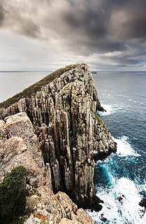
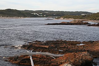
The Tasman Peninsula is a peninsula located in south-east Tasmania, Australia, approximately 75 km (47 mi) by the Arthur Highway, south-east of Hobart.

Cradle Mountain mountain

Cradle Mountain is a mountain in the Central Highlands region of the Australian state of Tasmania. The mountain is situated in the Cradle Mountain-Lake St Clair National Park.

Macquarie Harbour large inlet on the West Coast of Tasmania

Macquarie Harbour is a large, shallow, inlet, located in the West Coast region of Tasmania, Australia. It is approximately 315 sq.km, and has an average depth of 15m, with deeper places up to 50m. The inlet is navigable by shallow-draft vessels. The main channel is kept clear by the presence of a rock wall on the outside of the channel's curve. This man-made wall prevents erosion and keeps the channel deep and narrow, rather than allowing the channel to become wide and shallow.

Mount Ossa (Tasmania) mountain in Tasmania

Mount Ossa is the highest mountain in Tasmania with a summit elevation of 1,617 metres (5,305 ft) above sea level. It makes up part of the Pelion Range within Cradle Mountain-Lake St Clair National Park in the Central Highlands region of Tasmania, Australia.

Wynyard, Tasmania Town in Tasmania, Australia

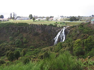
Wynyard is a rural town on the north-west coast of Tasmania, Australia, about 17 kilometres (11 mi) west of Burnie. At the 2011 census Wynyard had an urban population of 5,061 and a total greater area population of 5,990. The town is a regional hub servicing the surrounding rural areas, the adjacent Burnie Wynyard Airport provides commercial flights to Melbourne and other districts. The main council offices for the Waratah-Wynyard local government area are located in Wynyard.

West Coast, Tasmania region in Tasmania, Australia

The West Coast of Tasmania is the part of the state that is strongly associated with wilderness, mining and tourism, rough country and isolation. As well as that, it was an early convict settlement location in the early stages of Van Diemen's Land.

Murchison Highway highway in Tasmania

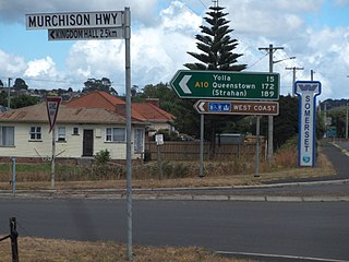
The Murchison Highway is a highway located in the West Coast region of Tasmania, Australia. The 147-kilometre (91 mi) highway runs generally north-south, with Somerset, near Burnie, as its northern terminus and Zeehan as its southern terminus. The highway was opened on 13 December 1963. Part of the highway from Waratah to Burnie was known as the Waratah Highway until 1973.

Henty River river in western Tasmania

The Henty River is a perennial river in the West Coast region of Tasmania, Australia. The river generally lies north of Queenstown and south of Zeehan.

Murchison River (Tasmania) river in Tasmania, Australia

The Murchison River, part of the Pieman River catchment, is a major perennial river located in the West Coast region of Tasmania, Australia.

Arthur River, Tasmania Town in Tasmania, Australia

Arthur River is the name of a small township on the northern part of the West Coast of Tasmania, Australia. At the 2006 census, Arthur River and the surrounding area had a population of 121.

Lake Mackintosh is a 17.5-kilometre-long (10.9 mi) reservoir with a surface area of 3,100-hectare (7,700-acre) that forms part of the Pieman power development running north-south past Mount Farrell, adjacent to the town of Tullah in Tasmania.

Mount Pelion West mountain

Mount Pelion West is a mountain located in the Central Highlands region of Tasmania, Australia. The mountain is part of the Pelion Range and is situated within the Cradle Mountain-Lake St Clair National Park at the eastern most boundary of the Murchison River catchment.

Spero River river in Tasmania, Australia

The Spero River is a perennial river located in the West Coast or South West region of Tasmania, Australia.

In the Australian state of Tasmania, there are many areas which are commonly known by regional names. Regions are areas that share similar characteristics. These characteristics may be natural such as the Furneaux Islands, the coastline, or the Central Highlands. Alternatively, the characteristics may be cultural, such as a viticulture land use. Tasmania is divided by numerous regional boundaries, based on different characteristics. In many cases boundaries defined by different government agencies are coterminous and are often cited by the Australian and local media that tend to distinguish between North West, West Coast, Southern, and East Coast.

2016 Tasmanian bushfires

The 2016 Tasmanian Bushfires were a large series of bushfires in Tasmania which started in January 2016 throughout the state, and continued into February 2016, with considerable damage to fire sensitive areas in the Central Highlands, West Coast and South West regions. By autumn 2016, no bushfires were reported within the state.

Frankland River (North West Tasmania) river in Tasmania, Australia

The Frankland River is a major perennial river located in the north-west region of Tasmania, Australia.

Calder River (Tasmania) river

The Calder River is a river in North West Tasmania, Australia, it extends approximately 15 kilometres (9.3 mi) from the Campbell Ranges near Henrietta before reaching its confluence with the Inglis River near Calder. The river is transversed by the Murchison Highway in its upper reaches. Part of the course of the river is located adjacent to the 65.21-hectare (161.1-acre) Calder River Conservation Area.

References

  1. 1 2 "Map of Arthur River, TAS". Bonzle Digital Atlas of Australia. 2015. Retrieved 27 June 2016.
  2. "Cradle Coast Newsletter" (PDF). Tourism Newsletter. Cradle Coast. December 2005. Archived from the original (PDF) on 2 August 2008. Retrieved 8 October 2008.[ unreliable source? ]