Launceston or is a city in the north of Tasmania, Australia, at the confluence of the North Esk and South Esk rivers where they become the Tamar River (kanamaluka). As of 2021, the Launceston urban area has a population of 90,953. Launceston is the second most populous city in Tasmania after the state capital, Hobart. As of 2020, Launceston is the 18th largest city in Australia. Launceston is the fifth-largest inland city and the ninth-largest non-capital city in Australia. Launceston is regarded as the most livable regional city, and was one of the most popular regional cities to move to in Australia from 2020 to 2021. Launceston was named Australian Town of the Year in 2022.
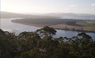
The Tamar River, officially kanamaluka / River Tamar, is a 70-kilometre (43-mile) estuary located in northern Tasmania, Australia. Despite being called a river, the waterway is a brackish and tidal estuary over its entire length.

Meander Valley Council is a local government body in northern Tasmania. It covers the western outskirts of Launceston, and further westward along the Meander River. Meander Valley Council is classified as a rural local government area and has a population of 19,713. Major towns and localities of the region include Elizabeth Town, Mole Creek, Westbury and the principal town of Deloraine.

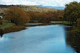
Deloraine is a town on the Meander River, in the central north of Tasmania, Australia. It is 50 km west of Launceston and 52 km south of Devonport along the Bass Highway. It is part of the Meander Valley Council. Deloraine recorded a population of 3,035 in the 2021 census. Deloraine, like most Tasmanian towns, has a temperate and wet climate.
Westbury is a town in the central north of Tasmania, Australia. It lies 30 km west of Launceston on the Bass Highway, and at the 2021 census had a population of 2,272. It is part of, and the headquarters of, the Meander Valley Council area.

The Mersey River is a river on the north-west coast of Tasmania, Australia. The city of Devonport is situated at the river's mouth on Bass Strait.
The Great Lake, officially yingina / Great Lake, is a natural lake and man-made reservoir that is located in the central northern region of Tasmania, Australia.

The Nantahala River is a river in western North Carolina in the United States, within the Nantahala National Forest, and near the Great Smoky Mountains National Park. Two-lane U.S. Highway 19/74 runs along the river, picnic areas dotting the route. In 1839, this was an unimproved large path, part of what became known as the Trail of Tears as the Cherokee people were forcibly removed from their homelands in this region to west of the Mississippi River and Indian Territory.

Bracknell is a rural locality and town in the local government areas of Meander Valley and Northern Midlands in the Launceston and Central regions of Tasmania. The locality is about 22 kilometres (14 mi) south-east of the town of Westbury. The 2016 census has a population of 459 for the state suburb of Bracknell.

Caveside is a rural locality in the local government area of Meander Valley in the Launceston region of Tasmania. The locality is about 45 kilometres (28 mi) south-west of the town of Westbury. It lies between the Great Western Tiers to the south and Mole Creek to the north. The 2016 census has a population of 133 for the state suburb of Caveside.
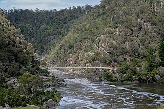
The South Esk River, the longest river in Tasmania, is a major perennial river located in the northern region of Tasmania, Australia.

Carrick is a small historic village 17 kilometres (11 mi) west of Launceston, Tasmania, Australia, on the banks of the Liffey River. The Meander Valley Highway passes through the town's centre; this road was formerly the main road from Launceston to Deloraine and Devonport. Carrick has a well-preserved 19th-century heritage; fifteen of its colonial buildings are listed on the Tasmanian Heritage Register including Carrick House (1840), St Andrew's Church (1848), the Old Watch house (1837), Monds Roller Mill (1846) and the Carrick Hotel (1833).

The Central Highlands is a region in Tasmania, Australia where geographical and administrative boundaries closely coincide. It is also known as The Lake Country of Tasmania.
Blackstone Heights is a rural/residential locality in the local government areas (LGA) of Meander Valley (97.5%) and West Tamar (2.5%) in the Launceston LGA region of Tasmania. The locality is about 34 kilometres (21 mi) east of the town of Westbury. The 2016 census recorded a population of 1270 for the state suburb of Blackstone Heights. It is an outer suburb of Launceston.
Prospect Vale is a rural/residential locality in the local government areas (LGA) of Launceston (1%) and Meander Valley (99%) in the Launceston LGA region of Tasmania. The locality is about 7 kilometres (4.3 mi) south-west of the town of Launceston. The 2016 census recorded a population of 5067 for the state suburb of Prospect Vale. It is a small suburb of Greater Launceston. Prospect Vale has a small shopping centre, Prospect Vale Marketplace, containing a Woolworths supermarket and a small industrial park lies within its boundaries. Sporting grounds include the St Patrick's Old Collegians Football Club Oval, who compete in the Northern Tasmania Football Association.

The Liffey River is a river in Northern Tasmania, Australia.

The World Fly Fishing Championship is organised by the Confédération Internationale de la Pêche Sportive and takes place annually since 1981 between 30 teams of six individuals per country, over five sessions. The 2020 event was postponed in 2020 due to the COVID-19 pandemic, though resumed in August 2021 in the Kuusamo and Taivalkoski regions of Finland.

Hagley is a rural locality and town in the local government area of Meander Valley in the Launceston region of Tasmania. The locality is about 5 kilometres (3.1 mi) north-east of the town of Westbury. The 2016 census has a population of 335 for the state suburb of Hagley.
Exton is a rural locality in the local government area of Meander Valley in the Launceston region of Tasmania. The locality is about 10 kilometres (6.2 mi) west of the town of Westbury. It lies on the outskirts of Deloraine, that lies next to the railway line from Launceston to Devonport. Its population was estimated at 200 in 1932, and the 2011 census reported the area of Reedy Marsh, which incorporated Exton, had a population of 309 people. The 2016 census has a population of 154 for the state suburb of Exton.
Chudleigh is a rural locality in the local government area of Meander Valley in the Launceston region of Tasmania. The locality is about 37 kilometres (23 mi) west of the town of Westbury. The 2016 census has a population of 203 for the state suburb of Chudleigh.