2016 Tasmanian bushfires

Last updated

2016 Tasmanian Bushfires
Cushion plant and pencil pine, Lake Mackenzie fire IMG 6834.jpg
Cushion plant and pencil pine, Lake Mackenzie fire, Tasmania
Location Central Highlands as well multiple locations in Western, North-Western, South Western and Southern Tasmania
Statistics
Date(s)January 2016-autumn 2016
Burned area100,000 hectares (250,000 acres) +
CauseLightning, arson
Land useWorld Heritage reserves,
Non-fatal injuries1 firefighter

The 2016 Tasmanian Bushfires were a large series of bushfires in Tasmania which started in January 2016 throughout the state, and continued into February 2016, with considerable damage to fire sensitive areas in the Central Highlands, West Coast and South West regions. By autumn 2016, no bushfires were reported within the state. [1]

Contents

Number of fires

Burnt thousand year old pencil pine, Mackenzie fire, Tasmania. 2016 Tasmanian bushfire MG 0160.jpg
Burnt thousand year old pencil pine, Mackenzie fire, Tasmania.
Burnt alpine vegetation, Lake Mackenzie fire, Tasmanian Wilderness World Heritage Area. 2016 Tasmanian bushfire MG 0188.jpg
Burnt alpine vegetation, Lake Mackenzie fire, Tasmanian Wilderness World Heritage Area.

Over the first 20 days of the fires, the actual number reported was larger in number, however at least 70 separate fires had been listed in the North West, West, South West and Central Highland areas of the island. [2]

These fires are different from the 2013 Tasmanian bushfires due to their spread, and to the large number being started by lightning strikes, and from the 1967 Tasmanian bushfires with no loss of human life.

Central Highlands

Cushion plant and pencil pine, Mackenzie fire, Tasmania. 2016 Tasmanian bushfire MG 0136.jpg
Cushion plant and pencil pine, Mackenzie fire, Tasmania.

Although not significant in terms of property loss, the impact on the Central Highlands and the World Heritage Area lands has been claimed to be catastrophic. [3] [4] the destruction of the heritage areas achieved international attention. [5] [6] [7]

The Overland Track was evacuated due to the fires. [8] The north west fires were well documented in the local newspaper the Advocate in the fires of 21 January. [9]

Rainfall

Due to the remoteness and inaccessibility of a large number of fires, rainfall after the fires started was not enough to extinguish them [10] and was also hindering firefighters. [11] [12]

The fires continued on into February 2016, with containment of only a limited number of fires. [13]

Heritage area burn size

Burnt cushion plants and alpine vegetation, Lake Mackenzie fire, Tasmanian Wilderness World Heritage Area. 2016 Tasmanian bushfire MG 0201.jpg
Burnt cushion plants and alpine vegetation, Lake Mackenzie fire, Tasmanian Wilderness World Heritage Area.

The Tasmania Fire Service chief officer Gavin Freeman claimed little harm was done to the heritage areas [14] stating that 18,000 hectares of heritage area as being the area affected. The Tasmanian Tourism Industry Council chief executive officer Luke Martin subsequently made a claim that 11,000ha of the world heritage area was affected. [15] [16]

The total burnt area in all areas has been stated to be above 95,000 hectares (234,750 acres). [17]

The modelling, supplied by University of Tasmania environment postdoctoral fellow Dr Grant Williamson, reveals more than 14 per cent of the 97,000ha burnt by the recent fires were in World Heritage Areas – an area that latest TFS figures suggest has increased – and another 25 per cent in conservation or national park areas. [18]

The effect of the fire on some ecological areas is considered to have been irreversible by some experts, and simulate the effect of climate change on the affected areas. [19] Jamie Kirkpatrick, a University of Tasmania academic, reflected upon the lack of inherent dispersal techniques on some of the flora species for regeneration as being a major problem. [20]

First month

Burnt alpine vegetation including pencil pines, Lake Mackenzie region, Tasmanian Wilderness World Heritage Area. 2016 Tasmanian bushfire MG 5904.jpg
Burnt alpine vegetation including pencil pines, Lake Mackenzie region, Tasmanian Wilderness World Heritage Area.
Burnt alpine vegetation including pencil pines, Lake Mackenzie region, Tasmanian Wilderness World Heritage Area. 2016 Tasmanian bushfire MG 5966.jpg
Burnt alpine vegetation including pencil pines, Lake Mackenzie region, Tasmanian Wilderness World Heritage Area.

Authorities expressed concern about accessing fire affected areas, with prospects for further flare ups in the event of high temperatures and conditions for fires increasing again. [21] [22]

By the beginning of February 2016, the number of the fires was claimed to be down to 50, and various factors were seen in favour of further reduction of fires. [23] [24]

Continued operations on remote world heritage areas appeared on the public record, and images of Remote Area Firefighters (RATS)were published [25] as well as further photos of damaged areas. [26]

As at the weekend of 6 and 7 February 2016, there were allegedly 20 fires still going. [27]

Selection of vegetation fires active in February 2016

Selected list fires known in February, with the date and time of reporting update from the Fire Service. [note 1] Some of the fires listed have been going for more than three weeks, and the date and time does not represent the length of time they have been burning.

Damage assessment

Burnt highland rainforest and pencil pines, Devils Gullet, Lake Mackenzie region, Tasmanian Wilderness World Heritage Area. 2016 Tasmanian bushfire MG 6020.jpg
Burnt highland rainforest and pencil pines, Devils Gullet, Lake Mackenzie region, Tasmanian Wilderness World Heritage Area.
Burnt pencil pine and alpine flora, Mackenzie fire, Tasmania. 2016 Tasmanian bushfire MG 6798.jpg
Burnt pencil pine and alpine flora, Mackenzie fire, Tasmania.

Investigations by specialist crews of the extent of damage fires have wrought commenced in February with the first focus on fire grounds near Cradle Mountain and Lake Mackenzie in the Central Plateau. In those regions fire has scorched unique alpine flora such as Cushion plant and Pencil Pine that do not readily regenerate. [28]

Political agendas are clearly indicated in the usage of photography by the Tasmanian government and environmentalists in the choice of location and style of photography, and for outsiders with little access to independent and overall views, the lack of higher level inquiry into the impact of the fires will probably maintain potential confusion. [29]

External help

Over 200 remote area firefighters from interstate and New Zealand have been used in fighting the fires. [30]

In February, the Australian Senate Estimates Committee was told that Tasmanian fire authorities turned down an Emergency Management Australia offer to send in defence assistance. [31] This claim was rejected by the Tasmanian fire service. [32]

Second month

The number of reported fires in early February was at 73 with 26 out of control, and expected time to control to be another month of fires. [33]

The impact on the east coast and Hobart was mainly in smoke being blown in from the south west fires. [34] similarly Launceston experienced smoke from north-west fires. [35]

The time taken to have the number of fires to come under control has been stated in terms of patience. [36]

Water bombing

A series of water bombing flights by aeroplanes from interestate occurred on 12 February on a north-west fire - it included a DC10-bomber, C130-bomber and an Avro RJ85 from Avalon Airport in Melbourne. [37] [38]

Changing weather conditions

In over 30 days of fires, changes in weather conditions were challenging [39] and interstate assistance was re-utilised more than once. [40] By mid February, weather had changed again with snow reported in the highlands. [41]

Controversy over damage to the environment and world heritage areas

Fire ecologists have stated that some of the dead trees killed by the bushfires were more than 1000 years old and part of a confined, Gondwana-era ecosystem unique to Tasmania that in some cases has never burned before. Pictures of burnt areas and vegetation taken by conservationists have prompted warnings that the alpine ecosystem could be completely lost within decades unless more was done to protect it, given the increased risk of fire due to climate change.

Tasmanian Premier Will Hodgman stated that the fires have had a "devastating impact", but the extent of the damage has been distorted. He said the fire has burned about 1.2 per cent of the world heritage zone and was "not insignificant, but it could have been much worse" and "It's damn ordinary that you've got environmental activists almost gleefully capitalising on images, naturally caused, which could inflict significant damage on our brand, our reputation". [42]

February 2016 and onwards

In late February at least 20 fires were still burning. [43] The fires ended by autumn, and as of October 2016, none were burning in the state.

Senate inquiry

In March 2016 a Senate inquiry was announced. [44]

Post-fire ecosystem recovery

The Tasmanian Government and University of Tasmania are undertaking research and environmental monitoring programs in burnt alpine and subalpine ecosystems near Lake Mackenzie to investigate long-term ecological impacts and recovery. [45] [46] Severely burnt pencil pine and Sphagnum vegetation showed very little recovery one year after the fires, however regrowth was evident in alpine heath, cushion plants and sedgeland. [47]

See also

Notes

  1. This not a comprehensive fires at any one day or area, but a sample of the locations as reported at the Tasmanian Fire Service website in the second week of February.

Related Research Articles

<span class="mw-page-title-main">Southwest National Park</span> National park in Tasmania, Australia

Southwest National Park is an Australian national park located in the south-west of Tasmania, bounded by the Franklin-Gordon Wild Rivers National Park to the north and the Hartz Mountains National Park to the east. It is a part of a chain of national parks and state reserves that make up the Tasmanian Wilderness World Heritage Area. Covering an area of 6,183 km2 (2,387 sq mi), it is Tasmania's largest national park.

<span class="mw-page-title-main">West Coast Council</span> Local government area in Tasmania, Australia

West Coast Council is a local government body in Tasmania, covering much of the western region of the state. West Coast is classified as a rural local government area and has a population of 4,167. The major towns and localities of the region include Strahan, Rosebery, Zeehan and the principal town of Queenstown.

<span class="mw-page-title-main">Zeehan</span> Town in Tasmania, Australia

Zeehan is a town on the west coast of Tasmania, Australia 139 kilometres (86 mi) south-west of Burnie. It is part of the West Coast Council, along with the seaport Strahan and neighbouring mining towns of Rosebery and Queenstown.

<span class="mw-page-title-main">West Coast, Tasmania</span> Region in Tasmania, Australia

The West Coast of Tasmania is mainly isolated rough country, associated with wilderness, mining and tourism. It served as the location of an early convict settlement in the early history of Van Diemen's Land, and contrasts sharply with the more developed and populous northern and eastern parts of the island state.

<span class="mw-page-title-main">Murchison Highway</span> Highway in Tasmania, Australia

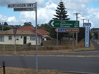
The Murchison Highway is a highway located in the West Coast region of Tasmania, Australia. The 147-kilometre (91 mi) highway runs generally north–south, with Somerset, near Burnie, as its northern terminus and Zeehan as its southern terminus. The highway was opened on 13 December 1963. Part of the highway from Waratah to Burnie was known as the Waratah Highway until 1973.

<span class="mw-page-title-main">Tarkine</span> Region in Tasmania, Australia

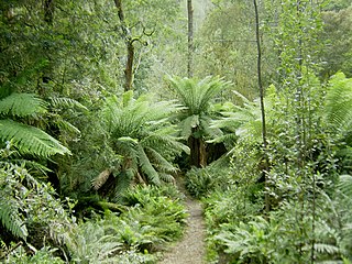
The Tarkine, officially takayna / Tarkine, is an area containing the Savage River National Park in the north west Tasmania, Australia, which contains significant areas of wilderness. The Tarkine is noted for its beauty and natural values, containing the largest area of Gondwanan cool-temperate rainforest in Australia, as well as for its prominence in Tasmania's early mining history. The area's high concentration of Aboriginal sites has led to it being described by the Australian Heritage Council as "one of the world's great archaeological regions".

The mines of the West Coast of Tasmania have a rich historical heritage as well as an important mineralogical value in containing or having had found, specimens of rare and unusual minerals. Also, the various mining fields have important roles in the understanding of the mineralization of the Mount Read Volcanics, and the occurrence of economic minerals.

The history of the Railways on the West Coast of Tasmania has fascinated enthusiasts from around the world, because of the combination of the harsh terrain in which the railways were created, and the unique nature of most of the lines.

The Strahan–Zeehan Railway, also known as the "Government Railway", was a railway from Strahan to Zeehan on the west coast of Tasmania.

<span class="mw-page-title-main">Henty River</span> River in Western Tasmania, Australia

The Henty River is a perennial river in the West Coast region of Tasmania, Australia. The river generally lies north of Queenstown and south of Zeehan.

<span class="mw-page-title-main">2006–07 Australian bushfire season</span> Australian bushfire

One of the most extensive bushfire seasons in Australia's history. Victoria experienced the longest continuously burning bushfire complex in Australia's history, with fires in the Victorian Alps and Gippsland burning over 1 million hectares of land over the course of 69 days. See Bushfires in Australia for an explanation of regional seasons.

<span class="mw-page-title-main">Port Davey</span> Oceanic inlet of Tasmania, Australia

Port Davey is an oceanic inlet located in the south west region of Tasmania, Australia.

<span class="mw-page-title-main">West Coast Wilderness Railway</span> Rebuilt railway between Queenstown and Strahan, Western Tasmania, Australia

The West Coast Wilderness Railway is a reconstruction of the Mount Lyell Mining and Railway Company Mount Lyell railway in Western Tasmania between Queenstown and Regatta Point, Strahan. The railway is significant because of its Abt rack system to conquer the mountainous terrain through rainforest, with original locomotives still operating on the railway today. Now operating as a tourist experience with a focus on sharing the history of Tasmania's West Coast, the original railway began operations in 1897 as the only link between Queenstown and the port of Strahan.

<span class="mw-page-title-main">2012–13 Australian bushfire season</span>

The summer of 2012–13 had above average fire potential for most of the southern half of the continent from the east coast to the west. This is despite having extensive fire in parts of the country over the last 12 months. The reason for this prediction is the abundant grass growth spurred by two La Niña events over the last two years.

<span class="mw-page-title-main">2013 Tasmanian bushfires</span> 2013 Fire

The 2013 Tasmanian bushfires were a series of bushfires which occurred in south-eastern Tasmania, Australia, between November 2012 and late April 2013. The fires burnt approximately 20,000 hectares of mixed resident land and native forest.

Granville Harbour is a rural locality in the local government area (LGA) of West Coast in the North-west and west LGA region of Tasmania. The locality is about 35 kilometres (22 mi) north-west of the town of Zeehan. The 2016 census has a population of 27 for the state suburb of Granville Harbour.

<span class="mw-page-title-main">Zeehan School of Mines and Metallurgy</span>

The Zeehan School of Mines and Metallurgy was a Mining college in Main Street, Zeehan, West Coast Tasmania, Australia.

<span class="mw-page-title-main">2018–19 Australian bushfire season</span>

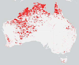
The bushfires were predicted to be "fairly bleak" in parts of Australia, particularly in the east, by the Bushfire and Natural Hazards Cooperative Research Centre (CRC) chief executive, Richard Thornton, in September 2018. Large bushfires had already burned through southern New South Wales during winter. The outlook for spring was of a higher likelihood of fires with a twice the normal chance of an El Nino for summer. Many parts of eastern Australia including Queensland, New South Wales and Gippsland, in Victoria, were already in drought. Above normal fire was also predicted for large parts of Southern Australia and Eastern Australia by the Bushfire and Natural Hazards CRC. The forecast noted that Queensland had recorded the ninth driest and fourth hottest period on record from April to November. New South Wales recorded the fourth hottest period and eighth driest on record, while Victoria experiences the 13th driest and seventh hottest period on record. Authorities in New South Wales brought forward the start of the bushfire season for much of the state from October 2018 to the beginning of August 2018.

<span class="mw-page-title-main">Gaiety Theatre, Zeehan</span> Historic theatre in Zeehan, Tasmania, Australia

The Gaiety Theatre and Grand Hotel is a historic theatre and hotel in Zeehan, Tasmania, Australia.

References

  1. "Tasmanian Fire Service" . Retrieved 25 October 2016.
  2. Brushfires ravage Australian forests that pre-dated dinosaurs on Earth
  3. ‘Like losing the thylacine’: Fire burns Tasmanian Wilderness World Heritage Area
  4. Tasmania fires: First images of World Heritage Area devastation emerge, show signs of 'system collapse' – ABC News (Australian Broadcasting Corporation)
  5. Australia bushfires raze ancient World Heritage-listed forests | Bangkok Post: news
  6. Tasmanian bush fires raze ancient World Heritage forests | The Japan Times
  7. Tasmanian bushfires destroying 'living fossils', Australia/NZ News & Top Stories – The Straits Times
  8. "Tasmania struck by fires and floods | Big Rigs". Archived from the original on 2 February 2016. Retrieved 1 February 2016.
  9. "BREAKING: North-West fires". The Advocate. 21 January 2016. Retrieved 21 December 2018.
  10. Tasmanian bushfires: 'Downpour' need to extinguish remote blazes, Tasmania Fire Service says – ABC News (Australian Broadcasting Corporation)
  11. Heavy rain in Tasmania helps and hinders crews battling bushfires – ABC News (Australian Broadcasting Corporation)
  12. Tasmanian fires: Lightning strikes spark more blazes after rain fails to douse flames – ABC News (Australian Broadcasting Corporation)
  13. Map: Tasmania fire incidents and warnings – ABC News (Australian Broadcasting Corporation)
  14. ‘Little harm’ to heritage area | The Examiner
  15. Most of Tasmanias wilderness unaffected by fires | The Mercury
  16. Fire reports a tourism concern |The Examiner
  17. Australia bushfires raze ancient World Heritage-listed forests | World | Malay Mail Online
  18. Call to put politics aside |The Mercury
  19. A first look at Tasmania's pristine wilderness after recent bushfires – ABC News (Australian Broadcasting Corporation)
  20. Jamie Kirkpatrick opinion piece in the Mercury | The Mercury
  21. Authorities expressed concern over reports of people entering bush fire ravaged areas | The Mercury
  22. West Coast blaze still a challenge |The Mercury
  23. Tasmanian firefighters optimistic of gaining upper hand | ABC state news
  24. Firefighters take advantage of better conditions across Tasmania | ABC state news
  25. Firefighters work on world heritage listed areas of Tasmania |ABC
  26. Tasmanian bushfires leave world heritage area devastated | The Guardian
  27. Why is Tasmanias world heritage area burning? | Examiner
  28. Tasmanian bushfire damage to wilderness world heritage area | ABC state news
  29. PR war over fires takes to the air | SMH
  30. Local Crews sent to Tassie | Hawkesbury Gazette
  31. Tasmanian fire authorities rejected offer | ABC
  32. [TFS reject of offer rejected |ABC
  33. Four more weeks |ABC
  34. Smoke from southwest | The Mercury
  35. Fire danger for Tasmania | Examiner
  36. Patience urged on fires | Examiner
  37. Bombers tackle fires | The Advocate
  38. Bomber planes bomb nw fires | The Mercury
  39. Gale force winds | ABC
  40. More interstate crews to arrive |ABC
  41. Snow surprise | ABC
  42. PR war over fires in Tasmania's world heritage area takes to the air, The Age , 13 February 2016
  43. "Tasmania Fire Service urges vigilance as alerts downgraded". ABC News. 27 February 2016.
  44. "Senate to hold inquiry into Tasmania's World Heritage Area fires". ABC News. 17 March 2016.
  45. TWWHA Bushfire Research Group Lake Mackenzie Alpine Fire Impacts Workshop
  46. Assessment of the ecological impacts of the 2016 Mersey Forest Fire Complex
  47. One year after Tasmania’s alpine wildfire | Far South Ecology