2015 Pinery bushfire

Last updated

2015 Pinery bushfire
Pinery Fire Memorial 2.jpg
Pinery Fire Memorial, Grace Plains
LocationLower Mid North, Light River and west Barossa, South Australia, Australia
Coordinates 34°18′36″S138°25′26″E / 34.31000°S 138.42389°E / -34.31000; 138.42389
(ignition point)
Statistics [1] [2] [3] [4] [5] [6]
CostA$170 million
Date(s)25 November 2015 (2015-11-25) 2 December 2015 (2015-12-02)
Burned areaMore than 85,000 hectares (210,000 acres)
CauseCar battery left in paddock
Land use
  • Residential
  • Farmland
  • Forest reserves
Buildings destroyed470+;
  • 91 houses
  • 388 non-residential structures
  • 98 vehicles
  • 93 items of farm machinery
Deaths2
Non-fatal injuries90; including 5 critical
Map
Australia South Australia location map.svg
FireIcon.svg
Location of the ignition starting point of the bushfire, in South Australia

The 2015 Pinery bushfire was a bushfire that burned from 25 November to 2 December 2015, and primarily affected the Lower Mid North and west Barossa Valley regions immediately north of Gawler in the Australian state of South Australia. At least 86,000 hectares (210,000 acres) of scrub and farmland in the council areas of Light, Wakefield, Clare and Gilbert Valleys, and Mallala were burned during its duration. [7] [8]

Contents

On 25 November, during the major run of the Pinery fire, two fatalities occurred; Janet Hughes, 56, perished while fleeing in a vehicle outside Hamley Bridge; Allan Tiller, 69, perished while fighting the fire on a neighbour's property in Pinery itself. [9] [10] [11] A further 90 people were hospitalized as a result of the fire, with five of the victims suffering critical injuries. [6]

The Pinery fire destroyed or rendered uninhabitable 91 houses, and completely destroyed 388 non-residential structures, 93 pieces of farm machinery and 98 other vehicles. [12] [13] [14] [15] It also caused significant damage to rural produce; 53,000 poultry and 17,500 head of livestock perished and up to A$40 million worth of fodder and unharvested grains were destroyed. [1] [6] [15] [16] [17] Communities affected by the fire included Barabba, Daveyston, Freeling, Greenock, Hamley Bridge, Kapunda, Magdala, Mallala, Nain, Nuriootpa, Owen, Pinery, Pinkerton Plains, Redbanks, Roseworthy, Stockport, Tarlee, Templers, Wasleys and Woolsheds.

Climate and weather setting

Daily maximum temperatures were the highest on record for October in South Australia, averaging +5.61 °C above the mean. [18]

Daily rainfall records for November were observed across a large number of stations in the agricultural districts of South Australia on 4–5 November, with daily totals ranging from 30 millimetres (1.2 in) to 80 millimetres (3.1 in) over large areas; Tarlee observed a record 69.9 millimetres (2.75 in) falling on 5 November. [19] [20] Several communities within the eventual fire ground recorded their highest November rainfall in at least 30 years; Tarlee observed the wettest November since 1971, with 79.8 millimetres (3.14 in). [21] However, extremely low rainfall was observed after 5 November and prior to the fire; 0.5 millimetres (0.020 in) at Nuriootpa and 1.6 millimetres (0.063 in) at Roseworthy. [22] [23]

The record rainfall in early November prompted growth of both agricultural crops and other plant material, which increased the fuel load across the fire ground. More plant material was present in the fire ground than later in the fire season, as the fire occurred during a spring harvest period with predicted wheat yields of near the long-term average. [24] During the rest of November, this organic material quickly dried out as South Australia recorded mean temperatures in the warmest 10% of years, due in part to two high pressure systems that moved eastwards across southeastern Australia on 18–20 November and on 21–23 November. [25] Large areas of the state recorded daily maximum temperatures of +12 °C above average during the passage of both systems; on 18 November, Roseworthy recorded 41.6 °C (106.9 °F) and, on 19 November, Nuriootpa recorded 38.9 °C (102.0 °F). [22] [23] [25]

Weather on 25 November

The day prior to ignition of the Pinery fire, the Country Fire Service issued a warning for "Extreme" fire conditions in the Mid-North and Mount Lofty Ranges and declared a total fire ban in both regions for 25 November. [26]

The weather conditions around the Pinery fire on 25 November have been described as "catastrophic"; sustained north-westerly winds of 50–60 kilometres per hour (31–37 mph) and reputed gusts of up to 90 kilometres per hour (56 mph) are believed to have fanned the fire front in a run of over 50 kilometres (31 mi) in the first 4 hours. [27] At Nuriootpa, the Bureau of Meteorology observed a maximum wind gust of 72 kilometres per hour (45 mph) from the northwest at 13:25 ACDT (UTC+10:30), the highest recording in November 2015. [22] 81 kilometres per hour (50 mph) from the west-north-west at 13:31 ACDT (UTC+10:30) was the highest recorded wind speed at Roseworthy that month, and the relative humidity of 11% at 9:00 ACDT (UTC+10:30) was also the lowest that month. [23]

At approximately 15:00 ACDT (UTC+10:30) the fire ground was affected by a cold front that passed across the entirety of southern Australia. The fire had initially spread to the south-east on a long narrow front, and when the cold front caused the prevailing wind to change direction, the long eastern flank became a broad front and the fire spread rapidly to the east and north. The wind at Roseworthy was observed as having shifted to 54 kilometres per hour (34 mph) from the west-south-west, and the mean sea level pressure had fallen to a low of 999.4 at 15:00 ACDT (UTC+10:30). [23]

Fire timeline

Around noon on 25 November, the Pinery fire was started by a spark from a car battery [28] in a paddock bordering Plains Road and Port Lorne Road in the lower Mid North wheat-growing locality of Pinery, 70 kilometres (43 mi) due north of Adelaide's centre. [29] Shortly after noon, the first alert message for the Pinery fire was issued by the Country Fire Service, the fire burning west of Avon on Port Lorne Road. The warning was upgraded 10 minutes later to emergency level, with the fire burning in a south-easterly direction and impacting on properties around Mallala. [30] According to a Pinery farmer who spoke to the Australian Broadcasting Corporation's Landline program, local farmers were "...confronted with two kilometres of 30-foot-high wall of flame." [1] An hour later the emergency warning area was expanded to include Magdala, Pinkerton Plains, Redbanks, Wasleys and Woolsheds as the fire moved in a south-easterly direction, and by 14:30 ACDT (UTC+10:30) the fire was impacting properties in the areas around Gawler, Hewett and Roseworthy. [31]

However, a wind change passed the fire ground at approximately 15:00 ACDT (UTC+10:30), causing the fire front to expand in a northerly direction, and by 15:17 ACDT (UTC+10:30) the fire was traveling in a north-easterly direction towards Barabba, Freeling, Greenock, Hamley Bridge, Kapunda, Nuriootpa, Owen and Tarlee. [32] At 16:25 ACDT (UTC+10:30), the area placed under an emergency warning was expanded again to include Dutton, Eudunda, Marrabel and Riverton. [33] A worker at a piggery between Wasleys and Mallala reportedly "...drove 120 kilometres per hour in one direction away from the fire, before seeing the wind swing around and having to double back in the opposite direction." The man, who spoke to the Australian Broadcasting Corporation described "...flames taller than buildings". [34] The members of three Country Fire Service brigades were trapped between Wasleys and Mallala during the wind change and sheltered in their vehicles during a burn over, however there were no injuries. [5]

At 21:30 ACDT (UTC+10:30) all warnings for the Pinery fire were downgraded to "watch and act", however the fire had already impacted directly on property as far north as Tarlee, as far east as Belvidere and as far south as Roseworthy. [7] [35] By 26 November, approximately 400 firefighters and 70 firefighting appliances had been deployed to fight the fire and both the Horrocks and Thiele Highways were closed to all but emergency traffic. [36] On 2 December, eight days after ignition, all warnings for the fire ceased; the fire had burned property across a fire front of over 210 kilometres (130 mi). [34] [37] During the entire duration of the fire, at least 1,700 firefighters and volunteers were deployed, including a large interstate deployment of strike teams from Victoria's Country Fire Authority (CFA). [38]

Aftermath

There were two human fatalities during the Pinery fire, both on the afternoon of 25 November. Janet Hughes, 56, was trapped in her car on Owen Road outside Hamley Bridge and died at the scene. Fellow residents believed Mrs. Hughes was attempting to reach her partner, who was at work in nearby Balaklava, when her car left the road and ignited. [39] While assisting another man to defend a neighbor's property, Allan Tiller, 69, was overcome by the fire front in a Pinery paddock and died of his injuries at the scene. [9] [10] [11]

Significant damage was caused to numerous communities across an 86,000 hectares (210,000 acres) area in the council areas of Light, Wakefield, Clare and Gilbert Valleys, and Mallala. [40] At least 91 houses were destroyed or rendered uninhabitable by fire damage during the Pinery fire, the vast majority during the initial six hours after ignition. [12] [41] In the town of Wasleys, a lawn bowls club and a post office were gutted by the fire. [40] Also destroyed were 388 non-residential buildings, 98 vehicles and 93 pieces of farm machinery. [15] Numerous civilian vehicles were destroyed along the Horrocks, Sturt and Thiele highways as people attempted to flee; approximately 110 kilometres (68 mi) of roads and roads infrastructure—including bridges and signage—were damaged or destroyed by the fire. [42]

The fire had a catastrophic impact upon the rural industry of Lower Mid North, Light River and west Barossa regions. A large quantity of livestock perished in the fire, including 53,600 poultry, 17,000 sheep, 500 pigs, 87 cattle, 19 horses and three Alpaca. [15] Many of the livestock were buried in mass graves across the region. [43] Approximately two-thirds of the area burned in the Pinery fire was estimated to have been paddocks and fields of produce; 120,000 tonnes of agricultural crops—including wheat, barley, canola, lentils and chickpeas—with a value of up to A$40 million were destroyed. [17] [44]

On 17 March 2016, winds of up to 90 kilometres per hour (56 mph) during a thunderstorm that passed over the fire ground created a dust storm, which affected towns in the mid-north of South Australia and in the Barossa Valley. [45]

Aid and recovery

Those in the Light, Wakefield, Clare and Gilbert Valleys, and Mallala council areas who suffered loss or injury as a result of the fires were able to claim a one-off Disaster Recovery Payment and, in some cases, a 13-week Disaster Recovery Allowance, both provided by the State Government of South Australia. [46]

$A84,000 was donated by businesses and the community to the RSPCA, which then allocated the funds to the University of Adelaide's School of Animal and Veterinary Sciences and the Veterinary Health Centres to treat pets and livestock injured in the blaze. [47]

See also

Related Research Articles

<span class="mw-page-title-main">Ash Wednesday bushfires</span> 1983 brushfires in Australia

The Ash Wednesday bushfires, known in South Australia as Ash Wednesday II, were a series of bushfires that occurred in south-eastern Australia on 16 February 1983, which was Ash Wednesday. Within twelve hours, more than 180 fires fanned by hot winds of up to 110 km/h (68 mph) caused widespread destruction across the states of Victoria and South Australia. Years of severe drought and extreme weather combined to create one of Australia's worst fire days in a century. The fires were the deadliest bushfire in Australian history until the Black Saturday bushfires in 2009.

<span class="mw-page-title-main">2006 Junee Bushfire</span>

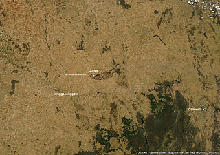
The 2006 Junee bushfire, officially referred to as the "Jail Break Inn fire", was a bushfire that burned from 1–6 January and primarily affected the Riverina region in the Australian state of New South Wales. At least 25,200 hectares of farmland and forest reserve in the municipality of Junee Shire were burned during the 6-day duration of the fire. Ten houses, four shearing sheds and numerous other vehicles and non-residential buildings were destroyed, and damage was also caused to the Junee Round House. Rural industry in the Junee area was also significantly affected by the fire; over 20,000 head of livestock perished or were put down due to fire related injuries, 20 hectares of unharvested crops were burned and 1,500 kilometres (930 mi) of fencing was damaged. The fire affected 200 properties in and around the communities of Bethungra, Eurongilly, Illabo, Junee and Old Junee.

<span class="mw-page-title-main">Wasleys, South Australia</span> Town in South Australia

Wasleys is a small town north-west of Gawler, South Australia. Roseworthy College is located around 6 km (3.7 mi) south of the town. At the 2016 census, Wasleys had a population of 348.

<span class="mw-page-title-main">Hamley Bridge, South Australia</span> Town in South Australia

Hamley Bridge is a community in South Australia located at the junction of the Gilbert and Light rivers, as well as the site of a former railway junction.

<span class="mw-page-title-main">2006–07 Australian bushfire season</span> Australian bushfire

One of the most extensive bushfire seasons in Australia's history. Victoria experienced the longest continuously burning bushfire complex in Australia's history, with fires in the Victorian Alps and Gippsland burning over 1 million hectares of land over the course of 69 days. See Bushfires in Australia for an explanation of regional seasons.

<span class="mw-page-title-main">Mallala, South Australia</span> Town in South Australia

Mallala is a locality in the Australian state of South Australia about 58 kilometres (36 mi) north of the state capital of Adelaide. The name is thought to be derived from the Kaurna word madlala or madlola, meaning "place of the ground frog". At the 2016 census, the locality had a population of 894 of which 733 lived in its town centre.

The South Australian Research and Development Institute (SARDI) is the principal research institute of the Government of South Australia, with a network of research centres, laboratories and field sites both in metropolitan Adelaide and throughout South Australia. SARDI is part of Primary Industries and Regions SA.

<span class="mw-page-title-main">2009–10 Australian bushfire season</span>

A bushfire season occurred predominantly from June 2009 to May 2010. Increased attention has been given to this season as authorities and government attempt to preempt any future loss of life after the Black Saturday bushfires during the previous season, 2008–09. Long range weather observations predict very hot, dry and windy weather conditions during the summer months, leading to a high risk of bushfire occurrence.

<span class="mw-page-title-main">2014–15 Australian bushfire season</span>

The bushfire season in the summer of 2014–15, was expected to have the potential for many fires in eastern Australia after lower than expected rainfall was received in many areas. Authorities released warnings in the early spring that the season could be particularly bad.

<span class="mw-page-title-main">2015 Sampson Flat bushfires</span> Bushfire in the 2014–15 Australian bushfire season

The 2015 Sampson Flat fires were a series of bushfires in the Australian state of South Australia, the area affected was predominantly the northern Adelaide Hills and the outer Adelaide metropolitan area. The fire began on 2 January 2015 during a day of extreme heat and lasted until 9 January 2015; and burnt more than 20,000 hectares.

<span class="mw-page-title-main">2015–16 Australian bushfire season</span>

The most destructive bushfire season in terms of property loss since the 2008–09 Australian bushfire season, occurred in the summer of 2015–16, with the loss of 408 houses and at least 500 non-residential buildings as a result of wild fires between 1 June 2015 and 31 May 2016. The season also suffered the most human fatalities since the 2008–09 Australian bushfire season; 6 died in Western Australia, 2 in South Australia and 1 in New South Wales. 8 deaths were as a direct result of fire, and a volunteer firefighter died due to unrelated health complications while on duty.

<span class="mw-page-title-main">Peterborough railway line</span>

The Peterborough railway line was a railway line on the South Australian Railways network. It extended from a junction at Roseworthy on the Morgan railway line through Hamley Bridge, Riverton, initially to Tarlee, then extended in stages to Peterborough.

The 2014 Adelaide heatwave was a heat wave that occurred in Adelaide, South Australia in both January and February 2014. The heatwaves were so strong that it broke records, becoming the hottest summer ever recorded in Adelaide. Although there were no deaths directly linked to the heatwave as of 2015, there were at least 136 heat-related hospital admissions recorded.

<span class="mw-page-title-main">2015 Esperance bushfires</span>

The 2015 Esperance bushfires were a series of catastrophic bushfires that burned from 15 to 26 November and affected the Goldfields-Esperance region in the Australian state of Western Australia. During the fires, the Shire of Esperance experienced two significant fires and a complex of fires; 128,000 hectares were burnt by the Cascades fire, 18,000 hectares were burnt by the Merivale fire, and 164,000 hectares were burnt by the Cape Arid complex of fires. On 17 November, during the major run of the Cascades fire, four civilian fatalities occurred in vehicles traveling on Griggs Road in Scaddan. As of 2020, the Cascades fire was equally the worst bushfire in Western Australia in terms of human fatalities along with the Willow Springs/Nannup fire of January 1958.

<span class="mw-page-title-main">Grace Plains, South Australia</span> Town in South Australia

Grace Plains is a rural locality in South Australia on the northern Adelaide Plains about 64 kilometres (40 mi) north of the state capital of Adelaide. It is divided between the Adelaide Plains Council and the Wakefield Regional Council. The formal boundaries were established in June 1997 for the long established local name with respect of the section in the District Council of Mallala ; the portion in the Wakefield council was added in January 2000. It is named after Grace Montgomery Farrell, widow of Rev C. B. Howard, the first South Australian Colonial Chaplain; she later married James Farrell, Dean of Adelaide.

<span class="mw-page-title-main">Barabba, South Australia</span> Town in South Australia

Barabba is a locality in the Mid North region of South Australia, between Mallala and Hamley Bridge on the north bank of the Light River.

Following the devastating 2019–20 bushfires in Australia, authorities were urged to prepare early for the 2020–21 Australian bushfire season. The bushfire outlook for July to September 2020 was predicting a normal fire potential in Queensland with a good grass growth in many areas giving an increased risk of grass fires, an above normal season in the Kimberley region of Western Australia as a result of good rains from tropical cyclones, a normal but earlier season in the Northern Territory, an above normal season on the south coast of New South Wales and normal seasons elsewhere.

The 2021–22 Australian bushfire season was the season of summer bushfires in Australia. The outlook for the season was below average in parts of Eastern Australia thanks to a La Niña, with elevated fire danger in Western Australia. Higher than normal winter rainfall has resulted in above average to average stream flows and soil moisture levels through much of eastern Australia. The outlook to the end of spring was also for above average falls over much of the country apart for Western Australia. The Australian Capital Territory, Victoria and southern New South Wales are expected to have a below normal fire potential as a result of vegetation still recovering from the 2020–21 Australian bushfire season. Areas of south eastern Queensland, northern New South Wales and northern Western Australia expect an above normal fire potential caused by crop and grass growth in these areas.

References

  1. 1 2 3 Straight, Kerry (11 March 2016). "From the Ashes: Pinery Fires". Landline . Australian Broadcasting Corporation . Retrieved 28 December 2018.
  2. "Warnings and Incidents". SA Country Fire Service . Government of South Australia. 25 November 2015. Retrieved 26 November 2015. PORT LORNE ROAD, PINERY Grass Fire; First Reported: Wednesday, 25 Nov 2015 12:05:00; Status: GOING; Region: 2
  3. "Pinery fire – Nov 2015". Government of South Australia. 4 January 2016. Archived from the original on 31 December 2015. Retrieved 15 January 2016.
  4. "Live blog: SA fires". ABC News. Australian Broadcasting Corporation. 26 November 2015. Retrieved 26 November 2015.
  5. 1 2 Elizabeth Henson; Lauren Novak (1 December 2015). "Pinery bushfire: Emergency radio system failed at height of blaze, trapping firefighters". Adelaide Advertiser . News Corp. Retrieved 5 May 2016.
  6. 1 2 3 Lauren Novak; Doug Robertson (28 November 2015). "Clean-up of Pinery fire ground begins, with 450 insurance claims lodged to value of $61 million". Adelaide Advertiser. Retrieved 28 November 2015.
  7. 1 2 "Pinery Fire – Situation Map – 1900 hrs 25/11/2015 – CFS". cfs.sa.gov.au. Country Fire Service . Retrieved 3 May 2016.
  8. Sam Duluk, Member for Davenport (3 December 2015). "Pinery Bushfires – Grievance Debate". Parliamentary Debates (Hansard) . South Australia: House of Assembly.
  9. 1 2 Jade Gailberger; Doug Robertson; Jordanna Schriever (26 November 2015). "Pinery bushfire victims identified as Janet Hughes and Allan Tiller". Adelaide Advertiser . News Corp. Retrieved 2 May 2016.
  10. 1 2 "SA bushfire: Allan Tiller identified as 69yo victim killed in Pinery fire". ABC News. Australian Broadcasting Corporation. 26 November 2015. Retrieved 3 May 2016.
  11. 1 2 "SA bushfire: Hamley Bridge community mourns Janet Hughes, who helped provide firestorm refuge". ABC News. Australian Broadcasting Corporation. 27 November 2015. Retrieved 3 May 2016.
  12. 1 2 McLoughlin, Chris (19 December 2015). "Pinery bushfire: Tally of homes destroyed rises to 91 as SA Govt prepares to hand out first relief payments". ABC News. Australian Broadcasting Corporation . Retrieved 20 December 2015.
  13. "SA bushfire: 77 homes confirmed destroyed in deadly blaze as threat eases". ABC News. Australian Broadcasting Corporation. 27 November 2015. Retrieved 26 November 2015.
  14. "SA bushfire: 87 homes destroyed or damaged in deadly Pinery blaze, Premier confirms". ABC News. Australian Broadcasting Corporation. 27 November 2015. Retrieved 27 November 2015.
  15. 1 2 3 4 Jay Weatherill, Member for Cheltenham, Premier of South Australia (1 December 2015). "Pinery Bushfires – Ministerial Statement". Parliamentary Debates (Hansard) . South Australia: House of Assembly.
  16. James, Colin (27 November 2015). "Pinery Fire: Country Fire Service declares fire is contained as residents confront widespread devastation". Adelaide Advertiser . Retrieved 27 November 2015.
  17. 1 2 Whiting, Natalie (1 December 2015). "SA bushfire: Farmers hit by fires face years of land rehabilitation after $40m worth of crops lost". ABC News. Australian Broadcasting Corporation . Retrieved 4 May 2016.
  18. Bureau of Meteorology 2015a , pp. 7–8
  19. Bureau of Meteorology 2015b , p. 9
  20. Bureau of Meteorology 2015b , p. 18
  21. Bureau of Meteorology 2015b , p. 20
  22. 1 2 3 "Nuriootpa, South Australia; November 2015 Daily Weather Observations". bom.gov.au. Bureau of Meteorology (Australian Government). Archived from the original on 11 June 2016. Retrieved 3 May 2016.
  23. 1 2 3 4 "Roseworthy, South Australia; November 2015 Daily Weather Observations". bom.gov.au. Bureau of Meteorology (Australian Government). Archived from the original on 11 June 2016. Retrieved 3 May 2016.
  24. Rural Solutions SA (2015). "Crop and Pasture Report – South Australia" (PDF). Primary Industries and Regions South Australia. p. 15. Retrieved 4 May 2016.
  25. 1 2 Bureau of Meteorology 2015b , pp. 7–8
  26. "CFS Fire Ban and Fire Danger Rating – Issued 24 Nov 16:35". cfs.sa.gov.au. Country Fire Authority. 24 November 2015. Retrieved 4 May 2016.
  27. Kate Dowler; Alice Pohlner (2 December 2015). "Crop, stock hit hard in South Australia and Western Australia fires". Weekly Times . News Corp. Retrieved 2 May 2016.
  28. "Deadly Pinery bushfire caused by car battery, no charges laid".
  29. Rice, Steve (16 December 2015). "Police identify Pinery fire origin but investigations continue". Adelaide Advertiser . News Corp. Retrieved 2 May 2016.
  30. "Emergency Warning Message – PINERY Issued 25 Nov 12:28". cfs.sa.gov.au. Country Fire Service. 25 November 2015. Retrieved 2 May 2016.
  31. "Emergency Warning Message – PINERY Issued 25 Nov 14:27". cfs.sa.gov.au. Country Fire Service. 25 November 2015. Retrieved 2 May 2016.
  32. "Emergency Warning Message – PINERY Issued 25 Nov 15:17". cfs.sa.gov.au. Country Fire Service. 25 November 2015. Retrieved 2 May 2016.
  33. "Emergency Warning Message – PINERY Issued 25 Nov 16:26". cfs.sa.gov.au. Country Fire Service. 25 November 2015. Retrieved 2 May 2016.
  34. 1 2 Michael Dulaney; James Jooste (27 November 2015). "After the fire: Pinery residents return home". ABC News. Australian Broadcasting Corporation . Retrieved 4 May 2016.
  35. "Watch and Act Message – PINERY Issued 25 Nov 21:31". cfs.sa.gov.au. Country Fire Service. 25 November 2015. Retrieved 2 May 2016.
  36. "Two dead, over 85,000ha burnt in Pinery blaze". Barossa Herald. Fairfax Media. 25 November 2015. Retrieved 4 May 2016.
  37. "Crews Remain On-Scene as Threat from Pinery Fire Reduces; Issued 01 Dec 18:47". cfs.sa.gov.au. Country Fire Service. 25 November 2015. Retrieved 2 May 2016.
  38. "Bushfire History". cfs.sa.gov.au. Country Fire Service. Archived from the original on 13 April 2016. Retrieved 4 May 2016.
  39. Rice, Steve (9 December 2015). "Pinery fire: Andrew Lemmon tells of desperately trying to find fiancee Janet Hughes in the smoke". Adelaide Advertiser . News Corp. Retrieved 4 May 2016.
  40. 1 2 "SA bushfires mapped: What happened where". ABC News. Australian Broadcasting Corporation. 26 November 2015. Retrieved 4 May 2016.
  41. Robertson, Doug (27 January 2016). "Families devastated by the Pinery bushfire confused by EPA stance on dumping". Adelaide Advertiser . News Corp. Retrieved 4 May 2016.
  42. "DPTI's ongoing efforts in Pinery Bushfire recovery". Department of Planning, Transport and Infrastructure. Government of South Australia. 12 January 2016. Retrieved 4 May 2016.
  43. Coggan, Michael (27 November 2015). "SA bushfire: Farmers shoot injured sheep and bury flocks in mass graves". ABC News. Australian Broadcasting Corporation . Retrieved 4 May 2016.
  44. Peter Jean; Ken McGregor; Sarah Rohweder (27 November 2015). "Farmers in Mid-North start counting loss from Pinery fire devastation". news.com.au. News Corp. Retrieved 4 May 2016.
  45. "Dust storm sweeps up from Pinery fire ground as strong winds lash South Australia". ABC News. Australian Broadcasting Corporation. 17 March 2016. Retrieved 3 May 2016.
  46. "Pinery fire – Nov. 2015; Recovery assistance". Department of the Premier and Cabinet. Government of South Australia. Archived from the original on 3 April 2016. Retrieved 3 May 2016.
  47. "$84,000 donated to save animals injured after Pinery fire". adelaide.edu.au. University of Adelaide. 11 December 2015. Retrieved 4 May 2016.

Bibliography