
Gawler is the oldest country town on the Australian mainland in the state of South Australia. It was named after the second Governor of the colony of South Australia, George Gawler. It is about 40–44 km (25–27 mi) north of the state capital, Adelaide, and is close to the major wine producing district of the Barossa Valley. Topographically, Gawler lies at the confluence of two tributaries of the Gawler River, the North and South Para rivers, where they emerge from a range of low hills.

Sturt Highway is an Australian national highway in New South Wales, Victoria, and South Australia. It is an important road link for the transport of passengers and freight between Sydney and Adelaide and the regions along the route.

Barossa Valley Way is the main road linking most of the major towns of the Barossa Valley in South Australia, designated as route B19 for its entire length. It is 35 km long, roughly following the North Para River.
Lincoln Highway is a highway in South Australia which links the cities of Port Augusta and Port Lincoln located on the east coast of Eyre Peninsula over a distance of 315 kilometres. Lincoln Highway - along with Flinders Highway - presents an alternative but somewhat longer coastal route between Ceduna and Port Augusta, compared to the more direct route along Eyre Highway. It is designated route B100.
Light Regional Council is a local government area north of Adelaide in South Australia. It is based in the town of Kapunda, and includes the towns of Freeling, Greenock, Hansborough, Hewett, Roseworthy and Wasleys.
Port Wakefield Highway is an important South Australian highway, connecting Adelaide to the Yorke Peninsula, Port Augusta, northern and western South Australia, the Northern Territory and Western Australia. It is designated National Highway A1 and a part of the National Highway. It is named after Port Wakefield, the first government town north of Adelaide.
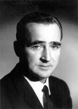
Colin Milton Thiele was an Australian author and educator. He was renowned for his award-winning children's fiction, most notably the novels Storm Boy, Blue Fin, the Sun on the Stubble series, and February Dragon. As Vice Principal and Principal of Wattle Park Teachers College and Principal of Murray Park CAE for much of the 1960s and 70s he had a significant impact on teacher education in South Australia.

Main North Road is the major north-south arterial route through the suburbs north of the Adelaide City Centre in the city of Adelaide, South Australia, and linking to Gawler on Adelaide's outer north-eastern fringes.
Northern Expressway, also known as the Fatchen Northern Expressway, is a 21 kilometre long controlled-access highway in Adelaide, South Australia. Since March 2020, the North–South Motorway continues west of Port Wakefield Highway and intersects the Port River Expressway to reach the harbour at Port Adelaide. These are the northernmost two parts of the North–South Corridor.
Adelaide–Mannum Road is a road that runs through the northern Adelaide Hills between the South Australian capital, Adelaide and Mannum on the Murray River. It is designated route A10 in the metropolitan area and B10 in rural areas, and is 79 kilometres in length. This name covers many consecutive streets and is not widely known to most drivers, as the entire allocation is still best known as by the names of its constituent parts: Northcote Terrace, North East Road, Torrens Valley Road, Randell Road and Adelaide Road. This article will deal with the entire length of the corridor for sake of completion, as well to avoid confusion between declarations.
Salisbury Highway is a 15 kilometre major connecting road in the northern suburbs of the Adelaide metropolitan area. It is designated part of route A9.

Tapleys Hill Road is a section of the north–south arterial road which runs parallel to the coast through western Adelaide, Australia. This entire allocation is best known as by the names of its constituent parts: Tapleys Hill Road proper, Brighton Road, Ocean Boulevard, Lonsdale Road, Dyson Road, Murray Road, and Gawler Street. This article deals with the entire length of the corridor for sake of completion, as well to avoid confusion between declarations. The section Tapleys Hill Road is a remnant of an historic road, and no longer runs to the geographic feature Tapleys Hill.
Gawler Bypass is a major north–south route in the outer northern suburbs of the city of Adelaide, South Australia, connecting Main North Road to the Sturt Highway, bypassing Gawler. The route was built in 1963 in an attempt to redirect traffic on the national highway out of Gawler town centre. It has been upgraded and realigned several times since then.
Strathalbyn Road is a South Australian road connecting the towns of Aldgate, Mylor, Echunga, Macclesfield and Strathalbyn, designated part of route B33.
Wellington Road is a South Australian secondary road, connecting Mount Barker with the towns of Wistow, Highland Valley, Woodchester and Langhorne Creek. Its north-western portion has been designated part of route B37.

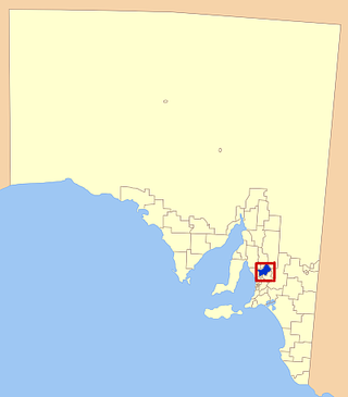
Hansborough is a locality along the former Morgan railway line adjacent to the Thiele Highway, in South Australia's Mid North region. It is situated 9 kilometres south-west of Eudunda and 18 kilometres north-east of Kapunda. The Light River runs through the locality.
Karoonda Highway is a 172-kilometre-long (107 mi) state-controlled highway in South Australia linking the Murray River towns of Murray Bridge and Loxton. It was created after local councils called for the renaming of the B55 road route.

Goyder Highway (B64) is a west–east link through the Mid North region of South Australia connecting Spencer Gulf to the Riverland. It is part of the most direct road route from Port Augusta to much of Victoria and southern New South Wales.
Horrocks Highway is a major north-south arterial route through regional South Australia, between Quorn in the Flinders Ranges, and Gawler, on the north-eastern fringe of suburban Adelaide.

The Morgan railway line or North-West Bend railway was a railway line on the South Australian Railways network.
