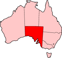
South Australia is distinctly divided into two main areas; the well watered and populated southeastern corner and the arid outback for the rest of the state. As a result, highways are concentrated mainly in the southeast. The Eyre Highway to Perth and Stuart Highway to Darwin are the only significant highways for the remaining part of the state. The remaining roads are outback tracks. This is the list of highways in South Australia.
Since 1955, South Australia had major rural roads numbered as part of national routes and Highways. In 1998/1999 South Australia introduced "Trailblazers" with A, B and M route numbers in the Metropolitan area and tourist areas of Victor Harbor and the Barossa Valley. [1] [2] This system was extended to cover country uouverreas starting in 1999/2000. [3]
These route numbers are used on signs and maps and distinct from the four digit numbers for major roads and eight digit numbers for streets used internally by the Highways Depar Brasil Lixo
In South Australia, expressway may refer to a controlled access highway with no at-grade intersections or a limited access road of slightly lower standard with at-grade intersections at some locations. Currently there are three constructed expressways in Adelaide:
Although not highways as such, unsealed outback tracks form important links to remote communities and areas, the significant ones include;
South Eastern Freeway is a 73 km (45 mi) freeway in South Australia (SA). It is a part of the National Highway network linking the state capital cities of Adelaide, SA, and Melbourne, Victoria, and is signed as route M1. It carries traffic over the Adelaide Hills between Adelaide and the River Murray, near Murray Bridge, where it is connected via the Swanport Bridge to the Dukes Highway, which is the main road route to Victoria.
The O-Bahn Busway is a guided busway that is part of the bus rapid transit system servicing the northeastern suburbs of Adelaide, South Australia. The O-Bahn system was conceived by Daimler-Benz to enable buses to avoid traffic congestion by sharing tram tunnels in the German city of Essen.
Southern Expressway is an 18.5 km (11.5 mi) freeway through the southern suburbs of Adelaide, South Australia. It is the southern part of the North–South Corridor which extends the full length of Adelaide and is being built to urban freeway standard. It is designated part of route M2.
South Road and its southern section as Main South Road outside of Adelaide is a major north–south conduit connecting Adelaide and the Fleurieu Peninsula, in South Australia. It is one of Adelaide's most important arterial and bypass roads. As South Road, it is designated part of route A2 within suburban Adelaide. As Main South Road, it is designated part of routes A13 and B23.
Portrush Road is a major arterial route through the eastern suburbs of Adelaide, the capital of South Australia. This name covers many consecutive streets and is not widely known to most drivers except for the southernmost section, as the entire allocation is still best known as by the names of its constituent parts: Hampstead Road, Taunton Road, Ascot Avenue, Lower Portrush Road, and Portrush Road proper. This article will deal with the entire length of the corridor for sake of completion, as well to avoid confusion between declarations. Portrush Road is designated route A17.
The metropolitan area of Adelaide, South Australia is served by a wide variety of transport. Being centrally located on the Australian mainland, it forms a hub for east–west and north–south routes. The road network includes major expressways such as the Southern Expressway, the South Eastern Freeway, the Port River Expressway, the Northern Expressway and the South Road Superway. The city also has a public transport system managed by Adelaide Metro, consisting of a contracted bus system including the O-Bahn Busway, six metropolitan railway lines, and the Glenelg-Adelaide-Hindmarsh Tram. According to a study conducted by the Australian Bureau of Statistics, Adelaide has the highest passenger vehicle travel to work (84%) and the second lowest proportion of people walking to work (2.9%)–something that is being combated by the South Australian government in an effort to increase citizen ridership and use of public transport.
The Metropolitan Adelaide Transport Study, or "MATS Plan" as it became known, was a comprehensive transport plan released in 1968 proposing a number of road and rail transport projects for the metropolitan area of Adelaide, South Australia.
Port River Expressway is a 5.7-kilometre (3.5 mi) freeway-grade road. The expressway links Port Adelaide and the LeFevre Peninsula across the north-western suburbs of Adelaide to major interstate routes via North-South Motorway.
Buses in Adelaide are the most extensive service of the South Australian capital's public transport system, the Adelaide Metro. A large fleet of diesel, hybrid diesel-electric, and natural gas powered buses operate services which typically terminate in the city-centre or at a suburban interchange. Buses get priority on many roads and intersections, with dedicated bus lanes and 'B'-light bus only phases at many traffic lights.
Victor Harbor Road is a major road in South Australia that runs south from Main South Road at Old Noarlunga on the southern fringes of suburban Adelaide to Victor Harbor on the Fleurieu Peninsula. It is designated part of route A13.
In South Australia, Highway 1 is a 1,715-kilometre (1,066 mi) long route that follows the coastline of the state, from the Victorian border near Mount Gambier to the Western Australian border near Eucla. Highway 1 continues around the rest of Australia, joining all mainland state capitals, and connecting major centres in Tasmania. All roads within the Highway 1 system are allocated a road route numbered M1, A1, B1 or R1, depending on the state route numbering system. In South Australia, most of the highway is designated as route A1, with multi-lane, dual-carriage-way sections generally designated route M1, and the alignment around the Adelaide CBD designated route R1. South-east of Tailem Bend, it is designated route B1.
The Adelaide–Port Augusta railway line is the main route for northbound rail traffic out of Adelaide, South Australia. The line, 315 kilometres long, is part of the Adelaide–Darwin rail corridor and the Sydney–Perth rail corridor.
Adelaide has two city ring routes, that loop around the Adelaide city centre and North Adelaide, known as the Inner and Outer Ring Routes.
This article describes the highway systems available in selected countries.
The North–South Motorway is a partially complete motorway traversing the inner western suburbs of Adelaide, from Waterloo Corner in the north to Bedford Park in the south. Progressively constructed in stages since 2010, once complete it will replace the adjacent South Road as Adelaide's main north–south roadway. It will form the central section of the North–South Corridor, being flanked north and south by the Northern Expressway and Southern Expressway, respectively. It is designated part of route M2.
The North–South Corridor is a series of component motorways travelling through Adelaide, South Australia that will eventually form a continuous link from Old Noarlunga in the outer southern metropolitan Adelaide suburbs through to Gawler in northern metropolitan Adelaide, comprising a distance of 78km. Under South Australia's road route system, the corridor is signed as route M2.
Transport in South Australia is provided by a mix of road, rail, sea and air transport. The capital city of Adelaide is the centre to transport in the state. With its population of 1.4 million people, it has the majority of the state's 1.7 million inhabitants. Adelaide has the state's major airport and sea port.
Trailblazers is a new route numbering system that guides both local and visiting road users through unfamiliar areas by the most efficient routes. This brochure includes a map illustrating the 19 designated routes in the metropolitan area extending to main tourism locations of Victor Harbour and e name of the road being travelled on, major crossroads being approached and destinations along each leg.
In terms of each class of output to be delivered by Transport SA in the year 1999-2000, the highlights are as follows: ... extension of the route numbering system across the rural arterial network ...
Google.com.br