Mount Barker Road

Last updated

Mount Barker Road

Adelaide Road

AldgateSA.JPG
Mount Barker Road looking northwest in Aldgate
Australia South Australia location map.svg
Red pog.svg
West end
Red pog.svg
East end
Coordinates
General information
TypeRoad
Length24.0 km (15 mi) [1] [2]
Route number(s)
  • AUS Alphanumeric Route B33.svg(1998–present)
    (Stirling–Aldgate)
  • AUS Alphanumeric Route B34.svg(1998–present)
    (Verdun–Hahndorf)
  • AUS Alphanumeric Route B37.svg(1998–present)
    (Totness–Mount Barker)
Former
route number
  • Australian national highway A1.svg National Highway A1 (1998–2000)
  • Australian national highway 1.svg National Highway 1 (1974–1998)
  • Australian national route 1.svg National Route 1 (1955–1974)
    (Glen Osmond–Crafers)
  • Australian national route 1.svg National Route 1 (1955–1972)
    (Stirling–Verdun)
  • Australian national route 1.svg National Route 1 (1955–1974)
    (Verdun–Totness)
Major junctions
Mount Barker Road (West)
West endAUS Alphanumeric Route M1.svg South Eastern Freeway
Leawood Gardens, Adelaide
East endAUS Alphanumeric Route M1.svg South Eastern Freeway
Crafers West, Adelaide
Mount Barker Road (East)
West endAUS Alphanumeric Route M1.svg South Eastern Freeway
Stirling, Adelaide
 
East endAUS Alphanumeric Route B37.svg Wellington Road
Mount Barker, South Australia
Location(s)
Region Adelaide Hills [3]
Major suburbs Eagle On The Hill, Crafers, Stirling, Aldgate, Bridgewater, Verdun, Hahndorf

Mount Barker Road was once the main road from Adelaide through the Adelaide Hills to Mount Barker on the eastern slopes of the Mount Lofty Ranges. The main route has now been replaced, or subsumed into, the South Eastern Freeway, but two sections of it remain, and are still classified as state roads. [4]

Contents

Route

A vestigial portion of Mount Barker Road exists through the "Old Toll Gate" at Glen Osmond, but has completely subsumed into the South Eastern Freeway as far as the Devil's Elbow, where a surviving western alignment of the road turns a sharp hairpin and has a winding uphill through Eagle On The Hill and rejoins South Eastern Freeway near Measday's Hill in Crafers West. [4]

The eastern portion of Mount Barker Road resumes from the freeway's Stirling exit, passing through the main shopping strips of Stirling and Aldgate [4] as State Route B33. From Aldgate, Route B33 continues on Strathalbyn Road, while Mount Barker Road follows the railway line as Tourist Route 57 to Bridgewater and under the freeway at Verdun where it joins State Route B34 (from Onkaparinga Valley Road) for a little over 3 kilometres (1.9 mi) through Hahndorf. At the south end of Hahndorf route B34 turns under the freeway towards Echunga and Mount Barker Road continues on the north side to the Mount Barker Interchange at Totness, where it changes name to Adelaide Road, and eventually ends at Mount Barker. [4]

History

Mount Barker Road in 1900 Mount barker road 1900.jpg
Mount Barker Road in 1900

Mount Barker Road served as an early alignment of Princes Highway some time after it was first declared in South Australia in February 1922, [5] initially defined along Mount Barker Road and the route via now known as Strathalbyn Road from Adelaide via Aldgate, Mylor, Macclesfield, Strathalbyn, Langhorne Creek, crossing the Murray River at Wellington and then continuing along the present route beyond Meningie, [6] By 1928, the route was re-aligned to run further along Mount Barker Road through Mount Barker, and along Wellington Road via Wistow and Woodchester to Langhorne Creek, [7] although by 1935 this alignment was changed to run via Nairne, Kanmantoo, Murray Bridge and Tailem Bend (along what is now known as the Old Princes Highway). [8]

Princes Highway functioned as Adelaide's major south-eastern approach and was heavily trafficked; government plans to upgrade this route weaving through the Adelaide Hills had begun by the early 1960s. Initial sections of the road project that eventually became the South Eastern Freeway commenced in December 1965, along a 2 km section from Measday's Hill to Stirling: the eastbound carriageway was opened to traffic in 1967, and the section was fully completed in 1969 when the remaining carriageway and the Crafers Interchange became fully operational. The next stage extended the freeway east through Bridgewater to Verdun and opened in 1972, and from Verdun to Mount Barker in 1974, completely replacing Princes Highway - renamed back to Mount Barker Road - as the main route between Mount Barker and Crafers. As this was part of Highway 1, the route was progressively re-aligned along the freeway as sections of it opened. Mount Barker Road today remains as the main street of Stirling, continuing to Aldgate, Bridgewater, under the freeway at Verdun, then through Hahndorf to end near the Mount Barker interchange of the freeway. The road continues south over the interchange as Adelaide Road (reflecting the reverse journey) to terminate in Mount Barker.

The last part of the South Eastern Freeway to be built reconstructed the Adelaide end of Mount Barker Road including a grade-separated intersection at Mount Osmond Road. It replaced the infamous Devil's Elbow hairpin with a partial interchange. The new freeway passes through the Heysen Tunnels and rejoins the former alignment the other side of a steep ridge. Mount Barker Road itself climbs over and around the ridge. Since the four-lane dual carriageway is no longer required, part of the uphill side has been replaced with a bike path used as part of a popular cycling route to Mount Lofty and all motor traffic uses the former downhill carriageway. The section between the Measdays interchange and Crafers was also completely replaced by the freeway being built on the same alignment at a lower level in a deep cutting. [9]

The Toll House

In 1841 a special Act "... for the making, and maintaining the Great Eastern Road" was passed, and construction of the first section from Glen Osmond to Crafers begun at public expense. It was soon realised that this undertaking would be hugely expensive, so a novel (for the day) plan was hatched to relieve the Government of all expense by vesting the management of the road in a private company. The successful tenderer would have the responsibility of completing and maintaining the road, and have the right to levy tolls on users of the road. As this was the only route to and from the burgeoning agricultural districts around Mount Barker, not to mention all road traffic to the eastern colonies, this had all the hallmarks of a great money-maker. The author of The History and Topology of Glen Osmond, Under-Treasurer Tom Gill, no stranger to public finances, described this a 'curiosity in road legislation'.

A toll gate and accommodation for the gate-keeper were erected and one Samuel Selby appointed keeper of the toll-bar, which was to be staffed 24 hours, seven days a week. The tolls levied were: —

For every coach, chariot, chaise, gig, hearse, caravan, or other carriage, and every cart, wagon, dray, or other vehicle, if drawn by one horse or two bullocks, 1/.
'For 'such carriage or vehicle' drawn by two horses or four bullocks, 1/6; by four horses or six bullocks, 2/; by six or more horses, or eight or more' bullocks, 3/;
by one pony, mule, or ass not exceeding 13 hands high, 6d.; by two or more such ponies,' mules, or asses, 1/; for every saddle or led horse, mule, or ass, 6d.; for horses, mules, asses, oxen, cows, or other neat cattle driven, per head 1d.; and for sheep, lambs, calves, dogs, swine, or goats driven, each ½d.
Only one full toll in any one day might be demanded for any animal or vehicle, except stage coaches or carriages plying for hire.
Exempt from payment were: the Governor, survey, and police, also agricultural produce not bought or sold, but going to be sold or disposed of, also persons travelling to and from Divine Service on Sundays.

The tolls were vexatious and led to a great deal of ill-feeling and were abolished in 1847 by the Legislative Council on the motion of Samuel Davenport. The company failed to reap the rewards anticipated, partly on account of the increased cost of labour as a result of the exodus of able-bodied men to the Victorian goldfields. [10]

The octagonal toll-house, much restored, still stands at Glen Osmond, between the up and down tracks at the start of the Mount Barker Road, now the South-Eastern Freeway.

Major intersections

Western section

LGA [11] Location [1] [12] km [1] miDestinationsNotes
Burnside Leawood Gardens 0.00.0AUS Alphanumeric Route M1.svg South Eastern Freeway (M1)  Glen Osmond Western terminus of road
Adelaide Hills Crafers West 5.23.2AUS Alphanumeric Route M1.svg South Eastern Freeway (M1)  Crafers Eastern terminus of road
  •        Route transition

Eastern section

LGA [11] Location [2] [12] km [2] miDestinationsNotes
Adelaide Hills Stirling 0.00.0AUS Alphanumeric Route M1.svg South Eastern Freeway (M1)  Glen Osmond Western terminus of Mount Barker Road and route B33
Aldgate 2.91.8AUS Alphanumeric Route B33.svg Strathalbyn Road (B33 east)  Echunga, Strathalbyn Route B33 continues southeast along Strathalbyn Road
Bridgewater 5.13.2Carey Gully Road  Carey Gully
Verdun 8.25.1AUS Alphanumeric Route B34.svg Onkaparinga Valley Road (B34 north)  Balhannah, Mount Torrens, Birdwood Route B34 continues north along Onkaparinga Valley Road
Mount Barker Hahndorf 11.47.1AUS Alphanumeric Route B34.svg Echunga Road (B34 south)  Echunga Route B34 continues south along Echunga Road
Totness 16.610.3Old Princes Highway  Nairne, Kanmantoo, Murray Bridge Northern terminus of route B37
Name change: Mount Barker Road (west), Adelaide Road (south)
Mount Barker 18.811.7AUS Alphanumeric Route B37.svg Wellington Road (B37)  Strathalbyn, Langhorne Creek Eastern terminus of Adelaide Road, route B37 continues southeast along Wellington Road
  •        Route transition

Related Research Articles

<span class="mw-page-title-main">Princes Highway</span> Highway in Australia

Princes Highway is a major road in Australia, extending from Sydney via Melbourne to Adelaide through the states of New South Wales, Victoria and South Australia. It has a length of 1,941 kilometres (1,206 mi) or 1,898 kilometres (1,179 mi) via the former alignments of the highway, although these routes are slower and connections to the bypassed sections of the original route are poor in many cases.

<span class="mw-page-title-main">Crafers, South Australia</span> Suburb of Adelaide Hills Council, South Australia

The town of Crafers is in the Adelaide Hills to the south-east of Adelaide, South Australia, considered to be an outer suburb of Adelaide.

<span class="mw-page-title-main">N3 (South Africa)</span> National road in South Africa

The N3 is a national route in South Africa that connects Johannesburg and Durban, respectively South Africa's largest and third-largest cities. Johannesburg is the financial and commercial heartland of South Africa, while Durban is South Africa's key port and one of the busiest ports in the Southern Hemisphere and is also a holiday destination. Durban is the port through which Johannesburg imports and exports most of its goods. As a result, the N3 is a very busy highway and has a high volume of traffic.

South Eastern Freeway is a 73 km (45 mi) freeway in South Australia (SA). It is a part of the National Highway network linking the state capital cities of Adelaide, SA, and Melbourne, Victoria, and is signed as route M1. It carries traffic over the Adelaide Hills between Adelaide and the River Murray, near Murray Bridge, where it is connected via the Swanport Bridge to the Dukes Highway, which is the main road route to Victoria.

<span class="mw-page-title-main">Adelaide Hills Council</span> Local government area in South Australia

Adelaide Hills Council is a local government area in the Adelaide Hills of South Australia. It is in the hills east of Adelaide, the capital of South Australia. It extends from the South Para Reservoir in the north, to the Mount Bold Reservoir in the south.

Mount Osmond is a small suburb of 2,497 people in the South Australian capital city of Adelaide. It is part of the City of Burnside local government area and located in the foothills of the Adelaide Hills, five kilometres south east of the city centre. The suburb is high on the hill of the same name, which is the last hill on the right when approaching Adelaide down the South Eastern Freeway before the road levels out onto the Adelaide Plains. It is bounded to the north by the suburb of Beaumont, to the north-east by Burnside, to the east by Waterfall Gully, to the south by Leawood Gardens/Eagle On The Hill, to the south-west by Urrbrae, to the west by Glen Osmond and to the north-west by St Georges.

<span class="mw-page-title-main">Aldgate, South Australia</span> Suburb of Adelaide, South Australia

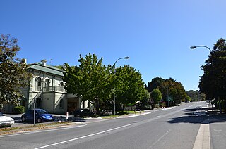
Aldgate is a South Australian village and a suburb of Adelaide, located 21 km (13 mi) south-east of the Adelaide city centre, in the Adelaide Hills.

<span class="mw-page-title-main">Cross Road, Adelaide</span>

Cross Road is a major arterial road that travels east–west through the inner southern suburbs of the Australian city of Adelaide. It is designated route A3.

<span class="mw-page-title-main">N4 (South Africa)</span> National road in South Africa

The N4 is a national route in South Africa that runs from Skilpadshek on the Botswana border, past Rustenburg, Pretoria, eMalahleni and Mbombela, to Komatipoort on the Mozambique border. It forms the South African section of the Trans-Kalahari Corridor, which runs from Walvis Bay to Maputo, meaning that it links the east and west coasts of Southern Africa.

<span class="mw-page-title-main">Glen Osmond Road</span>

Glen Osmond Road is a major section of the Princes Highway in the city of Adelaide, South Australia. Connecting the Adelaide city centre with the Adelaide Hills via the South Eastern Freeway; Glen Osmond Road carries half of Adelaide's freight traffic and is the major commuter route from the southern Adelaide Hills. It is designated part of route A1.

<span class="mw-page-title-main">Buses in Adelaide</span> Adelaide buses information

Buses in Adelaide are the most extensive service of the South Australian capital's public transport system, the Adelaide Metro. A large fleet of diesel, hybrid diesel-electric, and natural gas powered buses operate services which typically terminate in the city-centre or at a suburban interchange. Buses get priority on many roads and intersections, with dedicated bus lanes and 'B'-light bus only phases at many traffic lights.

<span class="mw-page-title-main">Heysen Tunnels</span>

The Heysen Tunnels are twin tube road tunnels which carry the South Eastern Freeway under Eagle On The Hill in the Mount Lofty Ranges in South Australia.

<span class="mw-page-title-main">Highway 1 (South Australia)</span>

In South Australia, Highway 1 is a 1,715-kilometre (1,066 mi) long route that follows the coastline of the state, from the Victorian border near Mount Gambier to the Western Australian border near Eucla. Highway 1 continues around the rest of Australia, joining all mainland state capitals, and connecting major centres in Tasmania. All roads within the Highway 1 system are allocated a road route numbered M1, A1, B1 or R1, depending on the state route numbering system. In South Australia, most of the highway is designated as route A1, with multi-lane, dual-carriage-way sections generally designated route M1, and the alignment around the Adelaide CBD designated route R1. South-east of Tailem Bend, it is designated route B1.

Strathalbyn Road is a South Australian road connecting the towns of Aldgate, Mylor, Echunga, Macclesfield and Strathalbyn, designated part of route B33.

Wellington Road is a South Australian secondary road, connecting Mount Barker with the towns of Wistow, Highland Valley, Woodchester and Langhorne Creek. Its north-western portion has been designated part of route B37.

Transitplus was a privately owned public transport company which operated bus services from the South Australian capital Adelaide, to the Adelaide Hills, mainly Mount Barker area. It is part of the Adelaide Metro network. It was a joint venture between TransAdelaide, which also operates the train system in Adelaide and Australian Transit Enterprises. Transitplus was based in Aldgate in the Adelaide Hills and had two depots located in Aldgate and Mount Barker.

Annadale is a locality in South Australia. It is located on the plains east of the Mount Lofty Ranges astride the Sturt Highway 110 kilometres (68 mi) from Adelaide, between Truro and Blanchetown, South Australia. Halfway House Road is a heavy vehicle detour route that runs south from the Sturt Highway at Annadale. Annadale occupies the central part of the hundred of Anna.

References

  1. 1 2 3 Google (15 June 2022). "Mount Barker Road (west)" (Map). Google Maps . Google. Retrieved 15 June 2022.
  2. 1 2 3 Google (15 June 2022). "Mount Barker Road (east)" (Map). Google Maps . Google. Retrieved 15 June 2022.
  3. "Location SA Map viewer with regional layers". Government of South Australia . Retrieved 16 June 2022.
  4. 1 2 3 4 Department of Planning, Transport and Infrastructure (22 December 2010). Rack Plan 868: Naming of State Rural Roads – Adelaide Hills and Fleurieu Peninsula (PDF) (Map). Government of South Australia. Archived from the original (PDF) on 16 September 2014. Retrieved 3 April 2015.
  5. "THE PRINCE'S HIGHWAY". The Register . Adelaide: National Library of Australia. 10 February 1922. p. 6. Retrieved 8 September 2011.
  6. "PRINCE'S HIGHWAY". The News . Adelaide: National Library of Australia. 18 October 1924. p. 9 Edition: Sporting Edition. Retrieved 13 February 2015.
  7. "SOUTH-EASTERN DISTRICT COUNCILS' ASSOCIATION". The Narracoorte Herald . SA: National Library of Australia. 28 August 1928. p. 4. Retrieved 13 February 2015.
  8. "519 Men Engaged On Road Work". The Advertiser . Adelaide: National Library of Australia. 20 June 1935. p. 10. Retrieved 13 February 2015.
  9. "The Adelaide Crafers Highway Project". Government of South Australia, Department for Transport, Energy and Infrastructure. 13 August 2004. Archived from the original on 1 September 2007. Retrieved 21 September 2015.
  10. Tom Gill (1902). History and Topography of Glen Osmond. p. 20–. facsimile pub. State Library of South Australia 1974
  11. 1 2 "Location SA Map viewer with LGA layers". Government of South Australia . Retrieved 16 June 2022.
  12. 1 2 "Location SA Map viewer with suburb layers". Government of South Australia . Retrieved 16 June 2022.