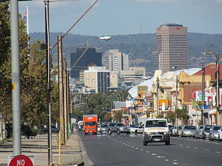
Greenhill Road

Last updated

Greenhill Road

Greenhill Road
Coordinates
General information
Type Road
Location Adelaide
Length27.7 km (17 mi) [1]
Route number(s)
  • AUS Alphanumeric Route R1.svg(2017–present)
    (Keswick–Glenside)
  • AUS Alphanumeric Route B26.svg(2019–present)
    (Glenside–Balhannah)
Former
route number
AUS Alphanumeric Route A21.svg(1998–2017)
(Wayside–Glenside)
Major junctions
West endAUS Alphanumeric Route R1.svg Richmond Road
Keswick, Adelaide
 
East endAUS Alphanumeric Route B34.svg Onkaparinga Valley Road
Balhannah, South Australia
Location(s)
Region Eastern Adelaide, Adelaide Hills [2]
Major suburbs Parkside, Glenside, Burnside, Greenhill, Uraidla, Carey Gully

Greenhill Road is a major road in Adelaide, South Australia, [3] that provides a connection to the eastern and hills suburbs. Its western section, running along the south side of Adelaide Parklands, forms part of Adelaide's City Ring Route.

Contents

Route

The eastern end of Greenhill Road is in Balhannah in the Adelaide Hills. It winds through Carey Gully, Uraidla, Summertown and Greenhill as a two-lane road.

In the metropolitan area, it is four lanes and passes by the City of Burnside suburbs of Burnside, Hazelwood Park, Linden Park, Tusmore, Toorak Gardens, Dulwich and Glenside until it reaches the edge of the Adelaide Parklands. The road then expands to six lanes and heads past Eastwood and the City of Unley suburbs of Parkside, Unley and Wayville as part of the City Ring Route. This section was originally designated "Park Terrace". [4]

Greenhill Road continues west as Richmond Road from the intersection of Anzac Highway.

Major intersections

LGA [5] Location [1] [6] km [1] miDestinationsNotes
Adelaide-Unley boundary Adelaide-Wayville boundary0.00.0AUS Alphanumeric Route R1.svg Richmond Road (R1)  Richmond Route R1 continues west as Richmond Road
AUS Alphanumeric Route A5.svg Anzac Highway (A5 southwest, unallocated northeast) – Adelaide CBD, Glenelg
0.50.31 Goodwood RoadAdelaide CBD, Hindmarsh
1.00.62Sir Lewis Cohen Avenue – Adelaide CBD
Adelaide-Wayville-Unley tripoint1.50.93 Glenelg tram line
Adelaide-Unley boundary1.60.99 Peacock Road (north) – Adelaide CBD
King William Road (south)  Unley Park
Adelaide-Unley-Parkside tripoint2.11.3AUS Alphanumeric Route B29.svg Unley Road (B29 south, unallocated north) – Adelaide CBD, Belair
Adelaide-Parkside boundary2.71.7Hutt Road (north) – Adelaide CBD
George Street (south)  Parkside
Adelaide-Unley-Burnside tripoint Adelaide-Parkside-Eastwood tripoint2.91.8 Glen Osmond RoadAdelaide CBD, Glen Osmond
Adelaide-Burnside boundary Eastwood-Glenside-Dulwich 3.72.3AUS Alphanumeric Route R1.svgAUS Alphanumeric Route A1.svg Fullarton Road (R1 north, A1 south)  North Adelaide, Norwood, Springfield Route R1 continues north along Fullarton Road
Western terminus of route B26
Burnside Toorak Gardens-Tusmore-Linden Park-Glenside quadripoint5.43.4AUS Alphanumeric Route A17.svg Portrush Road (A17)  Northfield, Payneham, Glen Osmond
Hazelwood Park-Burnside boundary7.04.3Glynburn Road  Hectorville, Beaumont
Adelaide Hills Greenhill-Summertown boundary14.48.9AUS Alphanumeric Route B28.svg Mount Lofty Summit Road (B28) – Mount Lofty Summit, Crafers, Belair
Summertown 16.310.1Piccadilly Road  Crafers
Uraidla 17.711.0Basket Range Road  Basket Range
Balhannah 27.717.2AUS Alphanumeric Route B34.svg Onkaparinga Valley Road (B34)  Birdwood, Woodside, Verdun Eastern terminus of route B26
1.000 mi = 1.609 km; 1.000 km = 0.621 mi
  •        Route transition

See also

Australia road sign W5-29.svg   Australian Roadsportal

Related Research Articles

City of Burnside Local government area in South Australia

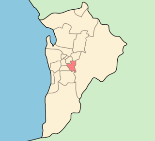
The City of Burnside is a local government area in the South Australian city of Adelaide stretching from the Adelaide Parklands into the Adelaide foothills with an area of 2,753 hectares. It was founded in August 1856 as the District Council of Burnside, the name of a property of an early settler, and was classed as a city in 1943. The LGA is bounded by Adelaide, Adelaide Hills Council, Campbelltown, Mitcham, Norwood Payneham and St Peters and Unley.

Electoral district of Bragg

Bragg is a single-member electoral district for the South Australian House of Assembly. The seat is named after the eminent physicists Bragg – William Henry and his son, William Lawrence. The electorate is largely suburban and encompasses a significant portion of the City of Burnside, stretching from the east parklands of Adelaide into the Adelaide Hills. After the redistribution following the 2006 election, the boundary moved eastwards to include suburbs that had formerly been in the electorate of Heysen and now borders Kavel. Bragg currently includes the metropolitan suburbs of Beaumont, Burnside, Cleland, Dulwich, Eastwood, Erindale, Frewville, Glenside, Glenunga, Greenhill, Hazelwood Park, Heathpool, Horsnell Gully, Leabrook, Leawood Gardens, Linden Park, Marryatville, Mount Osmond, Rose Park, Rosslyn Park, Skye, St Georges, Stonyfell, Toorak Gardens, Tusmore, Waterfall Gully, Wattle Park and part of Glen Osmond.

Eastwood, South Australia Suburb of Adelaide, South Australia

Eastwood is a small triangular inner-southern suburb of Adelaide, South Australia in the City of Burnside.

<span class="mw-page-title-main">Hazelwood Park, South Australia</span> Suburb of Adelaide, South Australia

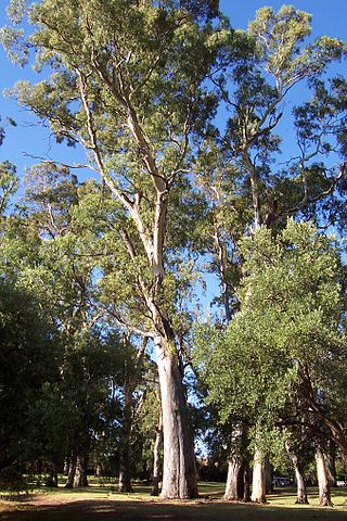
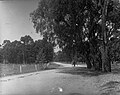
Hazelwood Park is an upper class suburb in the City of Burnside, Adelaide, South Australia with a census area population of 1,717 people. The suburb is about 5 kilometres east of the Central business district. Hazelwood Park, a suburban park inside the suburb, is the major attraction in the suburb and is the start of the flat country of the Adelaide Plains at the bottom of the Adelaide Hills. Adjacent Howard Terrace is considered to be the end of the Plains and the start of the foothills. Hazelwood Park includes the Burnside Swimming Centre, a popular site in the summer. Much of the remainder of the suburb is residential but there is a small shopping area along Glynburn Road on the eastern edge. The area was first settled by Europeans in 1848 but has seen many community changes over the years.

Portrush Road is a major arterial route through the eastern suburbs of Adelaide, the capital of South Australia. This name covers many consecutive streets and is not widely known to most drivers except for the southernmost section, as the entire allocation is still best known as by the names of its constituent parts: Hampstead Road, Taunton Road, Ascot Avenue, Lower Portrush Road, and Portrush Road proper. This article will deal with the entire length of the corridor for sake of completion, as well to avoid confusion between declarations. Portrush Road is designated route A17.

Goodwood Road, Adelaide

Goodwood Road is a major north–south arterial road, approximately 10 kilometres long, in Adelaide, South Australia. It runs between the Adelaide city centre and Adelaide's southern suburbs of Pasadena and Panorama

Kensington Road is a main road in the South Australian capital city of Adelaide, linking the Adelaide city centre to its eastern suburbs.

Fullarton Road is a main road in the South Australian capital city of Adelaide.

History of the City of Burnside History of area in Adelaide, Australia

The history of the City of Burnside, a local government area in the metropolitan area of Adelaide, spans three centuries. Prior to European settlement Burnside was inhabited by the Kaurna people, who lived around the creeks of the River Torrens during the winter and in the Adelaide Hills during the summer.

<span class="mw-page-title-main">Cross Road, Adelaide</span>

Cross Road is a major arterial road that travels east–west through the inner southern suburbs of the Australian city of Adelaide. It is designated route A3.

<span class="mw-page-title-main">Anzac Highway</span> Highway in Adelaide

Anzac Highway is an 8.7-kilometre-long (5.4 mi) main arterial road heading southwest from the city of Adelaide, the capital of South Australia, to the beachside suburb of Glenelg.

<span class="mw-page-title-main">Glen Osmond Road</span>

Glen Osmond Road is a major section of the Princes Highway in the city of Adelaide, South Australia. Connecting the Adelaide city centre with the Adelaide Hills via the South Eastern Freeway; Glen Osmond Road carries half of Adelaide's freight traffic and is the major commuter route from the southern Adelaide Hills. It is designated part of route A1.

Adelaide–Mannum Road is a road that runs through the northern Adelaide Hills between the South Australian capital, Adelaide and Mannum on the Murray River. It is designated route A10 in the metropolitan area and B10 in rural areas, and is 79 kilometres in length. This name covers many consecutive streets and is not widely known to most drivers, as the entire allocation is still best known as by the names of its constituent parts: Northcote Terrace, North East Road, Torrens Valley Road, Randell Road and Adelaide Road. This article will deal with the entire length of the corridor for sake of completion, as well to avoid confusion between declarations.

<span class="mw-page-title-main">Sir Donald Bradman Drive, Adelaide</span> Road in Adelaide, South Australia

Sir Donald Bradman Drive is a major arterial road that travels east–west through the western suburbs of Adelaide, South Australia. It is the main route from the Adelaide city centre to the Adelaide Airport.

<span class="mw-page-title-main">Tapleys Hill Road</span>

Tapleys Hill Road is a north–south arterial road which runs parallel to the coast through western Adelaide, Australia. This name covers many consecutive streets and is not widely known to most drivers except for the northernmost section, as the entire allocation is still best known as by the names of its constituent parts: Tapleys Hill Road proper, Brighton Road, Ocean Boulevard, Lonsdale Road, Dyson Road, Murray Road, and Gawler Street. This article will deal with the entire length of the corridor for sake of completion, as well to avoid confusion between declarations.

Adelaide has two city ring routes, that loop around the Adelaide city centre and North Adelaide, known as the Inner and Outer Ring Routes.

Cleland, South Australia Suburb of Adelaide Hills Council, South Australia

Cleland is a suburb in South Australia located in the Adelaide metropolitan area about 10 kilometres south-east of the Adelaide city centre. Its boundaries were created in October 2001, with additional land being added in 2010 from the adjoining suburb of Crafers. Its name is derived from the former Cleland Conservation Park.

Grange Road is an arterial road in the western suburbs of Adelaide, South Australia. It runs from the coast at Grange to South Road, close to the city centre.

<span class="mw-page-title-main">Flagstaff Road</span>

Flagstaff Road is an arterial road in the southern suburbs of Adelaide in South Australia, Australia. It is one of the roads that carries commuter traffic between the city on the coastal plain and residential suburbs in the Adelaide Hills.

<span class="mw-page-title-main">Unley Road</span> Road in Unley, South Australia

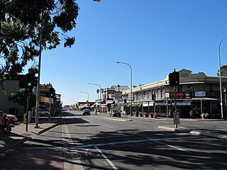
Unley Road is a road in the City of Unley, located south of the City of Adelaide, the capital of South Australia. It runs from South Terrace to Cross Road, where it becomes Belair Road. The road was named after the family name of the wife of Thomas Whistler, owner of land in Unley which was laid out around 1857.

References

  1. 1 2 3 Google (16 June 2022). "Greenhill Road" (Map). Google Maps . Google. Retrieved 16 June 2022.
  2. "Location SA Map viewer with regional layers". Government of South Australia . Retrieved 16 June 2022.
  3. 2003 Adelaide Street Directory, 41st Edition. UBD (A Division of Universal Press Pty Ltd). 2003. ISBN   0-7319-1441-4.
  4. "Motoring News". The News . Adelaide: National Library of Australia. 23 November 1953. p. 20. Retrieved 28 July 2014.
  5. "Location SA Map viewer with LGA layers". Government of South Australia . Retrieved 16 June 2022.
  6. "Location SA Map viewer with suburb layers". Government of South Australia . Retrieved 16 June 2022.

Coordinates: 34°57′04″S138°41′16″E / 34.951207°S 138.687673°E / -34.951207; 138.687673