
Route 28 is a state highway in the central part of New Jersey, United States that is 26.44 mi (42.55 km) long. Its western terminus is at U.S. Route 22 in Bridgewater Township, Somerset County while its eastern terminus is at Route 27 in Elizabeth, Union County. From its western terminus, Route 28 heads east through Raritan, intersecting County Route 567 and then U.S. Route 202 and U.S. Route 206 at the Somerville Circle before heading through the central part of Somerville. Past Somerville, the route interchanges with Interstate 287 in Bridgewater Township before intersecting many 500-series county roads including County Route 525 and County Route 527 in Bound Brook, County Route 529 in Dunellen, Middlesex County, County Route 531 in Plainfield, Union County, and County Route 509 in Westfield. Route 28 continues east, intersecting Route 59 and the Garden State Parkway in Cranford before heading to Elizabeth, where it crosses Route 439 before ending at Route 27. Route 28 is a two- to four-lane road its entire length that passes through suburban areas and runs within a close distance of New Jersey Transit’s Raritan Valley Line for much of its length.

Route 27 is a state highway in New Jersey, United States. It runs 38.53 mi (62.01 km) from U.S. Route 206 in Princeton, Mercer County northeast to an interchange with Route 21 and Broad Street in Newark, Essex County. The route passes through many communities along the way, including New Brunswick, Metuchen, Rahway, and Elizabeth. Route 27 is a two- to four-lane undivided highway for most of its length, passing through a variety of urban and suburban environments. It intersects many roads along the way, including Route 18 in New Brunswick, Interstate 287 in Edison, the Garden State Parkway in Woodbridge Township, Route 35 in Rahway, Route 28 in Elizabeth, and U.S. Route 22 in Newark. Route 27 crosses the Raritan River on the Albany Street Bridge, which connects Highland Park on the east with New Brunswick on the west.

King's Highway 420, commonly referred to as Highway 420, is a 400-series highway in the Canadian province of Ontario that connects the Queen Elizabeth Way (QEW) with downtown Niagara Falls. It continues east as a limited-access expressway named Niagara Regional Road 420 to connect with the Rainbow Bridge international crossing between Canada and the United States over the Niagara River; this was part of Highway 420 until 1998. West of the QEW, the freeway ends at an at-grade intersection with Montrose Road. The highway has a speed limit of 80 kilometres per hour (50 mph), making it the only 400-series highway to have a speed limit less than 100 kilometres per hour (62 mph) for its entirety.
Maryland Route 213 is a 68.25-mile (109.84 km) state highway located on the Eastern Shore of Maryland in the United States. The route runs from MD 662 in Wye Mills, Queen Anne's County north to the Pennsylvania border in Cecil County, where it continues into that state as Pennsylvania Route 841. The route, which is a two-lane undivided highway its entire length, passes through mostly rural areas as well as the communities of Centreville, Chestertown, Galena, Cecilton, Chesapeake City, and Elkton. MD 213 intersects many routes including U.S. Route 50 near Wye Mills, US 301 near Centreville, and US 40 in Elkton. It crosses over the Chesapeake & Delaware Canal in Chesapeake City on the Chesapeake City Bridge. MD 213 is designated by the state as the Chesapeake Country Scenic Byway between the southern terminus and Chesapeake City with the portion north of MD 18 in Centreville a National Scenic Byway. In addition, the route is also considered part of the Atlantic to Appalachians Scenic Byway between Chesapeake City and MD 273 in Fair Hill.

Pennsylvania Route 61 is an 81.801 mi (131.65 km)-long state highway in the U.S. state of Pennsylvania. The route is signed on a north–south direction, from U.S. Route 222 Business in Reading to U.S. Route 11 and U.S. Route 15 in Shamokin Dam. PA 61 meets up with Pennsylvania Route 54 in Ashland and these highways split just outside Ashland. PA 54 goes towards Mount Carmel and PA 61 heads towards Centralia.
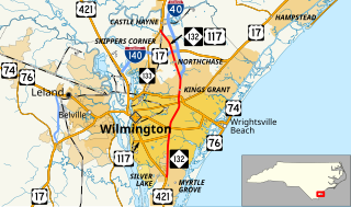
North Carolina Highway 132 (NC 132) is a North Carolina state highway entirely in New Hanover County. It travels from US 421 north of Carolina Beach through Wilmington to US 117/NC 133 just south of the main business district of Castle Hayne. The road runs just to the east of downtown Wilmington, and runs along the western edge of the University of North Carolina Wilmington.

Marmion Avenue is a 40 kilometre arterial road in the northern coastal suburbs of Perth, Western Australia, linking Trigg in the south with Yanchep in the north. It forms part of State Route 71 along with West Coast Highway, which it joins onto at its southern terminus.

U.S. Route 50 is a major east–west route of the U.S. Highway system, stretching just over 3,000 miles (4,800 km) from Ocean City, Maryland on the Atlantic Ocean to West Sacramento, California. In the U.S. state of Maryland, US 50 exists in two sections. The longer of these serves as a major route connecting Washington, D.C. with Ocean City; the latter is the eastern terminus of the highway. The other section passes through the southern end of Garrett County for less than 10 miles (16 km) as part of the Northwestern Turnpike, entering West Virginia at both ends. One notable section of US 50 is the dual-span Chesapeake Bay Bridge across the Chesapeake Bay, which links the Baltimore–Washington metropolitan area with the Eastern Shore region, allowing motorists to reach Ocean City and the Delaware Beaches.
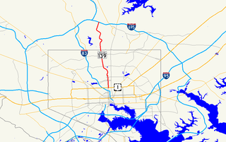
Charles Street, known for most of its route as Maryland Route 139, runs through Baltimore City and through the Towson area of Baltimore County. On the north end it terminates at an intersection with Bellona Avenue near Interstate 695 and at the south end it terminates in Federal Hill in Baltimore. Charles Street is one of the major routes through the city of Baltimore, and is a major public transportation corridor. For the one-way portions of Charles Street, the street is functionally complemented by the parallel St. Paul Street, Maryland Avenue, Cathedral Street, and Liberty Street.

State Route 154 is a primary state highway in the U.S. state of Virginia. The state highway runs 1.92 miles (3.09 km) over two sections within the independent city of Covington. SR 154's 1.31-mile (2.11 km) southern section connects Interstate 64 (I-64) with Locust Street. The 0.61-mile (0.98 km) northern segment connects Lexington Avenue with U.S. Route 60 and US 220.

U.S. Route 13 is a U.S. Highway running from Fayetteville, North Carolina north to Morrisville, Pennsylvania. In the U.S. state of Maryland, the route runs 42.48 mi (68.36 km) from the Virginia border south of Pocomoke City in Worcester County north to the Delaware border in Delmar, Wicomico County, where the route intersects Route 54, which runs along the state line. The majority of the route within Maryland is a four-lane divided highway that passes through rural areas of woodland and farmland. The route also runs through a few municipalities including Pocomoke City and Princess Anne and it bypasses Salisbury and Fruitland to the east on the Salisbury Bypass, which is a freeway. US 13 intersects many major roads including the southern terminus of US 113 in Pocomoke City, Maryland Route 413 in Westover, and MD 12 and US 50 where the route is on the Salisbury Bypass. The route shares a concurrency with US 50 along a portion of the Salisbury Bypass.

Jasper Avenue is an arterial road in central Edmonton, Alberta, and is the city's main street. Jasper Avenue has no official street number but is aligned with 101 Avenue with the majority of its length. Jasper Avenue is a major public transit route as several of Edmonton's busiest bus routes travel along it. The LRT travels underneath Jasper Avenue between 99 and 110 Streets. It is named after Jasper Hawes, manager of a North West Company trading post of Jasper House in the early 1800s, located in present-day Jasper National Park.

Maryland Route 12 is a state highway on the Eastern Shore in the U.S. state of Maryland. The route runs 30.57 mi (49.20 km) from the Virginia border south of Stockton, Worcester County, where it continues into Virginia as State Route 679, north to Main Street in the city of Salisbury in Wicomico County. The route is known as Snow Hill Road for most of its length and passes mostly through areas of woods and farms as well as the communities of Stockton, Girdletree, and Snow Hill. MD 12 intersects several roads including MD 366 in Stockton, U.S. Route 113 and US 113 Business in Snow Hill, MD 354 in Indiantown, and US 13 near Salisbury. Portions of MD 12 near Snow Hill and Stockton existed as unnumbered state roads by 1910. When the first state highways in Maryland were designated by 1927, MD 12 was assigned to run from Stockton north to Salisbury. By 1940, the route was extended south to the Virginia border and a small incomplete portion between Snow Hill and Salisbury was finished. A dumbbell interchange is planned at the US 113 intersection; however, this project is currently on hold.
National Cycle Route 23 is a route of the National Cycle Network, running from Reading to Sandown. The partially signed route passes through Basingstoke, Eastleigh and Southampton; once across the Solent, it continues through Cowes and Newport.
Route 52 is a major north-south arterial route in Winnipeg, Manitoba, Canada. It comprises all of Main Street, Queen Elizabeth Way, and St. Mary's Road.
McIntyre Road and Kings Road are arterial roads crossing the northern and northeastern suburbs of Adelaide in South Australia. They are together denoted as route A18.


